
Binn idir an dá Log facts for kids
Quick facts for kids Binn idir an dá Log |
|
|---|---|

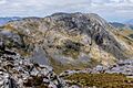
Northwest face and corrie lake of Lough Maumahoge, as viewed from Knocknahillion
|
|
| Highest point | |
| Elevation | 702 m (2,303 ft) |
| Prominence | 644 m (2,113 ft) |
| Listing | P600, 100 Highest Irish Mountains, Marilyn, Hewitt, Arderin, Simm, Vandeleur-Lynam |
| Naming | |
| English translation | peak between two hollows |
| Language of name | Irish |
| Geography | |

Binn idir an dá Log
Location in island of Ireland
|
|
| Location | County Galway, Republic of Ireland |
| Parent range | Maumturks |
| OSI/OSNI grid | L8881952827 |
| Topo map | OSi Discovery 37 |
| Geology | |
| Type of rock | Pale quartzites, grits, graphitic top bedrock |
| Climbing | |
| Easiest route | Via pass of Maumahoge |
Binn idir an dá Log is a mountain in Ireland. Its name means "peak between two hollows" in Irish. It stands tall at 702 metres (2,303 feet). This makes it one of the highest peaks in Ireland.
Binn idir an dá Log is located in the Maumturks mountain range. You can find it in the Connemara National Park in Galway. It is the tallest mountain in the entire Maumturks range.
What's in a Name?
The name Binn idir an dá Log comes from its shape. The mountain has a high, rocky top. On each side of this top, there are two large hollows. These hollows were carved out by glaciers long ago. One of these hollows now holds a lake.
Sometimes, people mistakenly call this mountain "Barrslievenaroy." This name actually belongs to a small area on the mountain's northern side. It is marked on some maps.
Exploring the Mountain
Binn idir an dá Log is right in the middle of the Maumturks range. This range stretches from the northwest to the southeast. The mountain has a long, winding top that is full of quartzite rocks and gravel.
There is a smaller peak nearby called Binn idir an dá Log SE Top. It is 659 metres (2,162 feet) high. To the southeast of the main peak, there is a big hollow. Beyond that is Binn Chaonaigh, another high mountain in the Maumturks.
To the northwest, you'll find an even bigger hollow. This one has a lake called Lough Maumahoge. The lake is surrounded by steep cliffs. From there, the land rises up to Knocknahillion mountain. The low area between Binn idir an dá Log and Knocknahillion is called the Maumahoge pass.
Binn idir an dá Log is considered a very important mountain. It is listed among the "100 Highest Irish Mountains." This is because it stands out so much from the land around it.
Hiking Adventures
Climbing Binn idir an dá Log can be a great adventure. The easiest way to reach the top is a 6-kilometre (3.7-mile) walk. This route takes about 3 hours and goes through the Maumahoge pass.
Many hikers also enjoy a longer journey. This is a 13-kilometre (8-mile) loop that takes 5-6 hours. It starts at a place called Maumeen. Hikers climb Binn Chaonaigh first, then continue to Binn idir an dá Log. After reaching the top, they go down through Maumahoge.
For very experienced hikers, there is the "Maamturks Challenge." This is a tough 25-kilometre (15.5-mile) walk. It takes 10–12 hours to complete. This challenge covers the entire Maumturks range. It is known as one of Ireland's "great classic ridge-walks." It is considered very difficult because of all the climbing involved.
Since 1975, the University College Galway Mountaineering Club has organized the "Maamturks Challenge Walk." They set up checkpoints on Binn idir an dá Log. One is at the very top of the mountain. Another is at Lough Maumahoge. These checkpoints help keep track of the hikers.
Rock Climbing
While the Maumturks range is not famous for rock climbing, some routes have been created. You can find climbing spots near Lough Maumahoge. These routes are between 90 and 190 metres long. They offer different levels of difficulty for climbers.
Images for kids
-
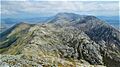
Summit ridge of Binn idir an dá Log viewed from the south on Binn Mhairg
-
View south from Letterbreckaun showing Knocknahillion (middle right), and Binn idir an dá Log (back, middle)
-
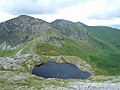
Looking north from summit of Binn idir and da Log to Lough Maumahoge, Knocknahillion and Letterbreckaun
-
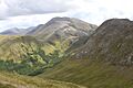
Binn idir an dá Log viewed from east spur of Letterbreckaun, with Knocknahillion on the right
.jpg)


