Binn Chaonaigh facts for kids
Quick facts for kids Binn Chaonaigh |
|
|---|---|

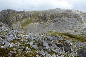
Binn Chaonaigh, as viewed from across the Máméan pass, on the north side of Binn Mhór
|
|
| Highest point | |
| Elevation | 633 m (2,077 ft) |
| Prominence | 108 m (354 ft) |
| Listing | Hewitt, Arderin, Simm, Vandeleur-Lynam |
| Naming | |
| English translation | peak of the moss |
| Language of name | Irish |
| Geography | |
| Location | Galway, Ireland |
| Parent range | Maumturks |
| OSI/OSNI grid | L9003751562 |
| Topo map | OSi Discovery 37 |
| Geology | |
| Type of rock | Pale quartzites, grits, graphitic top bedrock |
| Climbing | |
| Easiest route | Via pass of Maumean |
Binn Chaonaigh (which means "peak of the moss" in Irish) is a mountain in Ireland. It stands at 633 metres (2,077 ft) tall. This makes it one of the highest peaks in the country. It is the 185th highest on the Arderin scale and the 223rd highest on the Vandeleur-Lynam scale.
Binn Chaonaigh is located in the middle of the Maumturks mountain range. This range stretches from northwest to southeast in Connemara National Park. You can find it in Galway, Ireland. It is the fourth tallest mountain in the Maumturks range.
Contents
Exploring Binn Chaonaigh's Geography
Binn Chaonaigh is part of a small group of mountains. It sits between Binn idir an dá Log to the northwest and the large mountain pass called Maumeen or Máméan. Binn idir an dá Log is the highest peak in the Maumturks range, at 702 metres (2,303 ft).
Nearby Peaks and Passes
Just northeast of Binn Chaonaigh is a smaller peak called Binn Mhairg. Its name means "peak of woe." It is 612 metres (2,008 ft) high. Even though it's a bit off the main ridge, it's still considered a Vandeleur-Lynam peak.
South of the Máméan pass is Binn Mhór. This mountain is 661 metres (2,169 ft) tall. It is the third highest peak in the Maumturks range.
The Máméan Pilgrimage Site

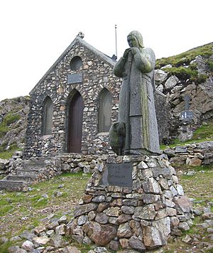
The Máméan pass, at the base of Binn Chaonaigh, is a special place. It has been a site for Christian pilgrimage for a very long time. People have visited here to honor Saint Patrick since the 400s. Before that, it was used for ancient festivals like Lughnasadh.
Over time, the pilgrimage became less popular. By the mid-1900s, it had almost stopped completely. However, in 1979, a man named Fr. Micheál MacGréil helped bring it back. He worked to improve the site and restart the annual pilgrimage.
What You Can Find at Máméan
Today, pilgrimages happen three times a year. These are on Saint Patrick's Day, Good Friday, and the first Sunday in August. The site has several important features:
- A holy well.
- A rock shelter called Saint Patrick's Bed (Leaba Phádraig). It's said that Saint Patrick slept here.
- A circle of stones used for the Stations of the Cross.
- A Mass Rock (Carraig an Aifrinn). This rock was used for secret Catholic services in the 1700s when the religion was not allowed in Ireland.
In the 1980s, Fr. MacGréil helped build a small chapel called Cillín Phádraig. In 1986, a sculptor named Cliodhna Cussen added a statue of Saint Patrick. It shows him as a shepherd with a sheep.
Stories of Saint Patrick at Máméan
The Irish storyteller Máire MacNeill wrote down many tales about Saint Patrick's visit to Máméan in 441 AD. Some stories describe his battles to get rid of the pagan god Crom Dubh. In these tales, Crom often turns into a bull. The bull then ends up drowning in the lake at Máméan.
Hiking Binn Chaonaigh
There are different ways to hike Binn Chaonaigh. The easiest way to reach the top is a 6-kilometer round trip. This hike takes about 2-3 hours and starts from the Maumean pass.
Longer Hiking Routes
Because Binn Chaonaigh is on the main rocky ridge of the Maumturks, it's often part of longer hikes. One popular route is a 13-kilometer loop. This takes about 5-6 hours. It starts at Maumeen, climbs Binn Chaonaigh, and then goes to the top of Binn idir an dá Log. Hikers then descend and walk back to Maumeen.
The Maamturks Challenge
Binn Chaonaigh is also a part of the Maamturks Challenge. This is a very long and difficult hike. It covers 25 kilometers and takes 10–12 hours. The challenge goes over the entire Maumturks range, from Maam Cross to Leenaun. It's known as one of Ireland's "great classic ridge-walks." It's considered "extreme grade" because of the total climb, which is about 7,600 feet.
Since 1975, the University College Galway Mountaineering Club has organized the annual "Maamturks Challenge Walk" (MCW). They set up checkpoints on either side of Binn Chaonaigh. One is at Maumeen, and another is at the summit of Binn idir an dá Log. The Binn idir an dá Log summit marks 54% of the climbing completed for the MCW.
 | Laphonza Butler |
 | Daisy Bates |
 | Elizabeth Piper Ensley |


