
Binn Mhór facts for kids
Quick facts for kids Binn Mhór |
|
|---|---|
| Irish: Binn Mhór | |

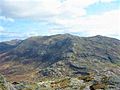
Binn Mhor as viewed across the pass of Máméan, from the summit of Binn Chaonaigh
|
|
| Highest point | |
| Elevation | 661 m (2,169 ft) |
| Prominence | 406 m (1,332 ft) |
| Listing | 100 Highest Irish Mountains, Marilyn, Hewitt, Arderin, Simm, Vandeleur-Lynam |
| Naming | |
| English translation | Great peak |
| Language of name | Irish |
| Geography | |

Binn Mhór
Location in island of Ireland
|
|
| Location | Galway, Ireland |
| Parent range | Maumturks |
| OSI/OSNI grid | L9184149355 |
| Topo map | OSi Discovery 44 |
| Geology | |
| Type of rock | Pale quartzites, grits, graphitic top bedrock |
| Climbing | |
| Easiest route | Via pass of Máméan |
Binn Mhór is a mountain in County Galway, Ireland. Its name means "great peak" in the Irish language. It stands at 661 metres (about 2,169 feet) tall.
Binn Mhór is the third-highest mountain in the Maumturks mountain range. This range is found in the beautiful Connemara National Park. It is also one of the 100 highest mountains in Ireland.
Contents
What's in a Name?
Other Names for Binn Mhór
Besides Binn Mhór, this mountain has also been called "Shannakeala." This is another name that people have used for the peak over time.
Exploring Binn Mhór's Location
Where is Binn Mhór Located?
Binn Mhór is in the southeastern part of the Maumturks range. It's separated from the main mountains by a deep valley called Máméan.
The Special Pass of Máméan
Máméan is a very old and special place. People have visited it for religious reasons since the 400s! It's dedicated to Saint Patrick, who is famous in Ireland.
At Máméan, you can find a holy well and a rock known as Saint Patrick's Bed. People believe Saint Patrick slept there. There's also a circle of stones for prayer and a Mass Rock, where religious services were held secretly long ago.
Peaks Around Binn Mhór
Binn Mhór has a high ridge with a few smaller peaks nearby.
- Binn Mhór West Top is 596 metres (1,955 feet) tall. It's also known as Binn Ramhar.
- Binn Mhór NE Top is 640 metres (2,099 feet) tall.
- Binn Mhór East Top is 630 metres (2,067 feet) tall.
Further east, you'll find other peaks like Mullach Glas (622 metres) and Corcogemore (609 metres).
Hiking Binn Mhór
How to Climb Binn Mhór
The easiest way to reach the top of Binn Mhór is from the Máméan pass. This hike is about 6 kilometres (3.7 miles) long and takes around 2 hours to go up and down.
You can also do a longer hike that starts from Corcogemore. This route goes across Mullach Glas to Binn Mhór's summit. It's about 10 kilometres (6.2 miles) long and takes 4 to 5 hours.
The Maamturks Challenge
Binn Mhór is part of a big hiking event called the Maamturks Challenge. This is a very tough walk, about 25 kilometres (15.5 miles) long! It takes 10 to 12 hours to complete the whole Maumturks range.
Hikers climb down from Binn Mhór (661 metres) to Máméan (only 150 metres) during the challenge. Then, they have to climb back up to Binn Chaonaigh (633 metres). It's a real test of endurance!
Gallery
-
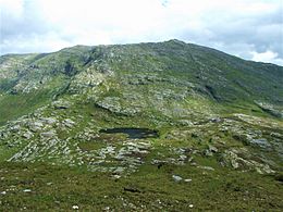
Massif of Binn Mhor, and the lough in Máméan, from summit of Binn Chaonaigh
-
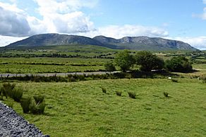
Corcogemore (left), Mullach Glas (centre), and Binn Mhor (right), as viewed from the north
-
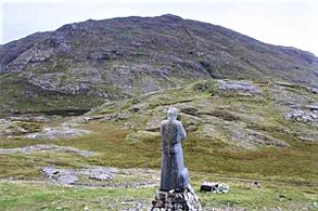
Binn Mhor from the statue of Saint Patrick at Máméan
-
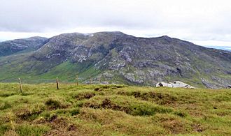
Mullach Glas (back left), and Binn Mhor (centre), viewed from Binn Chaonaigh

,_Mullach_Glas_(c)_%26_Binn_Mhor_(r)_from_the_North.jpg)


Images for kids
-
Mullach Glas (back left), and Binn Mhor (centre), viewed from Binn Chaonaigh
