
Leenaun Hill facts for kids
Quick facts for kids Leenaun Hill |
|
|---|---|
| Irish: An Meall Dubh | |

View north to Leenaun Hill from Letterbreckaun
|
|
| Highest point | |
| Elevation | 618 m (2,028 ft) |
| Prominence | 363 m (1,191 ft) |
| Listing | Marilyn, Hewitt, Arderin, Simm, Vandeleur-Lynam |
| Naming | |
| English translation | Black knoll |
| Language of name | Irish |
| Geography | |

Leenaun Hill
Location in island of Ireland
|
|
| Location | Leenaun, Galway, Ireland |
| Parent range | Maumturks |
| OSI/OSNI grid | L8743259343 |
| Topo map | OSi Discovery 37 |
| Geology | |
| Type of rock | Siltstone & sandstone Bedrock |
| Climbing | |
| Easiest route | Via Leenaun village |
Leenaun Hill (in Irish, An Meall Dubh, meaning 'black knoll') is a mountain in Ireland. It stands at 618 meters (2,028 feet) tall. This makes it one of the highest peaks in Ireland. It's located in County Galway, near the village of Leenaun.
Leenaun Hill is part of the Maumturks mountain range. It overlooks the beautiful Killary Harbour, which is Ireland's only fjord. Leenaun Hill is the 6th-highest mountain in the Maumturks. Its slopes are mostly grassy, made of sandstone and siltstone. This is different from other parts of the Maumturks, which have rocky peaks.
What's in a Name?
Leenaun Hill has also been called "Bunnaviskaun" and "Leenaun Mountain."
There is a smaller peak nearby called Búcán. Its name comes from an old word meaning "point" or "summit." You can find similar names for mountains in Southern France.
Where is Leenaun Hill?
Leenaun Hill is in the northeastern part of the Maumturk range. It is separated from the main mountains by a low pass. This pass is called the "Col of Despondency" by hill-walkers. It is about 250 meters (820 feet) high.
The rocks of Leenaun Hill are mostly siltstone and sandstone. This is different from the main part of the Maumturks, which has quartzite rocks. The tops of Leenaun Hill are grassy, unlike the rocky ridges of the main range.
A long grassy ridge runs through Leenaun Hill's area. Leenaun Hill is near the middle of this ridge. To the northwest are smaller peaks like Meall Cheo (578 meters or 1,896 feet). Further north is Leenaun Hill Far North-West Top (556 meters or 1,824 feet). The most northerly peak in the Maumturk range is Búcán (550 meters or 1,804 feet).
To the southwest of Leenaun Hill is another grassy ridge. It has a small peak called Taobh Dubh (422 meters or 1,385 feet), which means "black hillside."
Across the "Col of Despondency" is another peak called Maumturkmore (422 meters or 1,385 feet). This peak has a mix of different rocks. South of Maumturkmore is a steep pass called Maam Turk. This pass gives the entire mountain range its name. South of this pass are the rocky peaks of the main Maumturks range, including Letterbreckaun. Letterbreckaun is the 2nd-highest peak in the range at 667 meters (2,188 feet).
Hiking Leenaun Hill
The grassy slopes of Leenaun Hill are not as rocky as other peaks in the Maumturks. However, Leenaun Hill offers amazing views. You can see Killary Harbour, Ireland's deepest fjord, and the Mweelrea mountain range.
The easiest way to reach the top of Leenaun Hill is a 6-kilometer (3.7-mile) round trip. This walk starts and ends in Leenaun village and takes about 2–3 hours. You can also do a longer 11-kilometer (6.8-mile) loop. This loop also starts from Leenaun village. It takes about 4–5 hours and lets you visit Leenaun Hill and its northern peaks.
Leenaun Hill is also part of the Maamturks Challenge. This is a long 25-kilometer (15.5-mile) walk over the entire Maumturks range. It takes about 10–12 hours. This challenge is known as one of Ireland's "great classic ridge-walks." It is considered very difficult because of the total climb of about 7,600 feet.
Since 1975, the University College Galway Mountaineering Club has held the annual "Maamturks Challenge Walk." They have a checkpoint at Meall Cheo. Reaching the very top of Leenaun Hill is an optional part of this challenge.
Images for kids
-
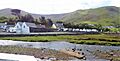
The area around Leenaun Hill, with Leenaun village, seen from across Killary Harbour on Ben Gorm
-
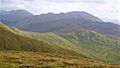
The "Col of Despondency" (middle) leading to Letterbreckaun (middle), with Binn idir an dá Log (far left)
-
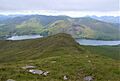
Leenaun Hill as seen from the cairn at Meall Cheo (578 meters)
-
Leenaun Hill (left), and Leenaun Far North West Top (right) from Leenane village

_%26_Letterbreckaun_(middle_right)_from_Leenane_Hill.jpg)
.jpg)
_and_Leenane_North_West_Top_(right)_from_Leenane_Village.jpg)
