
Benbrack facts for kids
Quick facts for kids Benbrack |
|
|---|---|
| Binn Bhreac | |
.jpg)
South face of Benbrack viewed from Muckanaght, with col of Maumnascalpa at right
|
|
| Highest point | |
| Elevation | 582 m (1,909 ft) |
| Prominence | 264 m (866 ft) |
| Listing | Marilyn, Arderin |
| Naming | |
| English translation | speckled peak |
| Language of name | Irish |
| Geography | |

Benbrack
Location in Ireland
|
|
| Location | Galway, Ireland |
| Parent range | Twelve Bens |
| OSI/OSNI grid | L7655855818 |
| Topo map | OSi Discovery 37 |
| Geology | |
| Type of rock | Pale quartzites, grits, graphitic top bedrock |
Benbrack is a mountain located in County Galway, Ireland. Its name, Binn Bhreac in Irish, means "Speckled Peak." This mountain stands 582 metres (1,909 ft) tall. It is known as a "Marilyn" because it rises significantly from the land around it.
Benbrack is found in the Connemara National Park. It is part of its own small mountain group, or massif, which is just north of the main Twelve Bens mountain range. Benbrack is the 10th-tallest peak among the core Twelve Bens. It is connected by a deep dip in the land, called a col, to Muckanaght. Muckanaght then connects to Benbaun, which is the tallest mountain in the Twelve Bens range, standing at 729 metres (2,392 ft).
Contents
What's in a Name? The Meaning of Benbrack
The name Benbrack, or Binn Bhreac, likely comes from the many speckled, light-colored stones. These are called quartzite stones and boulders. You can find them scattered all over the top of the mountain.
Exploring Benbrack's Surroundings
Benbrack sits on its own small mountain group. To the south, you'll find the larger Twelve Bens range, including Benbaun. A deep dip in the land, known as Maumnascalpa, connects Benbrack to mountains like Muckanaght (654 metres (2,146 ft)) and Benfree (638 metres (2,093 ft)).
To the north of Benbrack is Kylemore Lough, a beautiful lake. Across this lake, you can see the Garraun mountain group. This area is part of a special protected zone for nature.
Other Peaks Near Benbrack
- Knockbrack: To the west of Benbrack, there's a smaller peak called Knockbrack. It stands at 442 metres (1,450 ft) and its name means "speckled hill" in Irish.
- Benbaun (the smaller one): North of Benbrack, there's another peak also named Benbaun, which is 447 metres (1,467 ft) tall. To avoid confusion with the much taller Benbaun (729 metres (2,392 ft)) to the south, this smaller peak is sometimes called Maolán, meaning "knoll."
Valleys and Views
Benbrack is located where two large U-shaped valleys meet. Glencorbet Valley is to the east, and Polladirk Valley is to the west. You can get a great view of Polladirk Valley from the top of Diamond Hill.
To the northwest of Benbrack, there's a small valley and river called Mweelin. The peaks of Knockbrack, Benbrack, and the smaller Benbaun (477 m) form a horseshoe shape around Mweelin. This area is a popular spot for hikers.
Hiking Adventures on Benbrack
Benbrack is a great mountain for hiking! There are a few ways to explore it.
The Kylemore Abbey Route
The easiest way to climb Benbrack is a 5-kilometer (about 3 miles) round-trip hike. This walk usually takes about 2.5 hours. You start and finish at the car park near Kylemore Abbey. This path goes over the smaller Benbaun peak.
You can make this hike longer by doing the 7-kilometer (about 4.3 miles) Mweelin Horseshoe route. This takes about 3.5 hours and includes walking down via Knockbrack.
The Glencorbet Horseshoe
For a longer adventure, you can try the Glencorbet Horseshoe. This is a 14-kilometer (about 8.7 miles) circuit that takes 6 to 7 hours. It goes around the Kylemore River. Hikers usually do this route counter-clockwise. It includes several peaks:
- Benbaun (the 477-meter peak)
- Benbrack
- Muckanaght (optional)
- Benfree
- Benbaun (the 729-meter main peak)
- Ending at Knockpasheemore
Images for kids
-
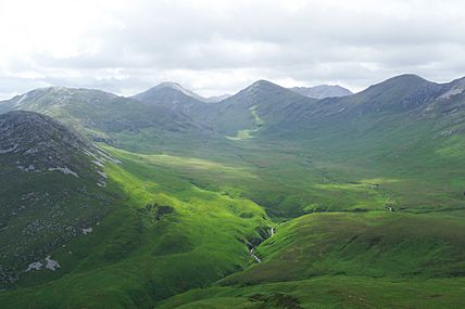
Polladirk Valley with Benbrack and Knockbrack to the left, as viewed from Diamond Hill
-
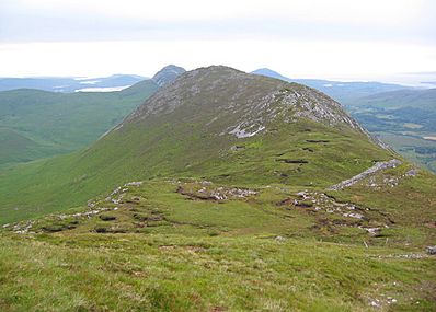
Summit of Knockbrack as viewed from the col with Benbrack
-
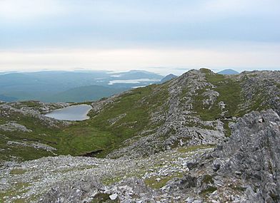
View northwest to Killary Harbour, from the summit of Benbrack


