
Diamond Hill (Ireland) facts for kids
Quick facts for kids Diamond Hill |
|
|---|---|
| Binn Ghuaire | |

Diamond Hill, viewed from Connemara National Park Visitor Centre in Letterfrack
|
|
| Highest point | |
| Elevation | 442 m (1,450 ft) |
| Prominence | 277 m (909 ft) |
| Listing | Marilyn |
| Naming | |
| English translation | Guaire's peak |
| Language of name | Irish |
| Geography | |

Diamond Hill
Location in Ireland
|
|
| Location | Letterfrack, Galway, Ireland |
| Parent range | Twelve Bens |
| OSI/OSNI grid | L7313857049 |
| Topo map | OSi Discovery 37 |
| Geology | |
| Type of rock | Pale quartzites, grits, graphitic top bedrock |
| Climbing | |
| Easiest route | National Park Visitor Centre |
Diamond Hill is a beautiful mountain in Galway, Ireland. Its Irish name is Binn Ghuaire, which means "Guaire's peak". Even though it's only 442 meters (about 1,450 feet) tall, it's a very popular spot.
The mountain is located near the village of Letterfrack. It's part of the Connemara National Park, which is in the northwest area of the Twelve Bens mountain range. Diamond Hill is well-known for its easy-to-follow paths and amazing views. From the top, you can see the main Twelve Bens mountains and the beautiful landscapes of western Connemara.
Contents
What's in a Name? The Story of Diamond Hill
Have you ever wondered how Diamond Hill got its name? The Irish name, Binn Ghuaire, probably comes from a famous king named Guaire Aidne mac Colmáin. He lived a long time ago, around the year 663.
King Guaire: A Generous Ruler
King Guaire was one of the Kings of Connacht. He was very famous for being kind and generous. People even called him "Guaire of the extended hand" because he was always helping others. A famous writer named W.B. Yeats wrote a play about him called The King’s Threshold. King Guaire is also connected to Dunguaire Castle, which is near a village called Kinvara.
Why "Diamond" Hill?
Diamond Hill is also sometimes called "Bengooria" or "Benhoowirra". These are English versions of its Irish name. The name "Diamond Hill" itself comes from the shiny quartz crystals found on the mountain. When the sun hits these crystals, they sparkle like diamonds!
Exploring the Geography of Diamond Hill
Diamond Hill stands out as a single peak in the northwest part of the Twelve Bens mountain range. Just to its east is a smaller peak called Knockbrack. This peak is also 442 meters tall and is part of the larger Benbrack mountain, which is 582 meters high.
Views from the Mountain
To the north of Diamond Hill, you can see Kylemore Lough and the famous Kylemore Abbey. Across the lake is another mountain area called Garraun. To the west, you can look out over Ballinakill harbour. On a clear day, you might even see the islands of Inishbofin and Inishark in the distance.
Looking south from Diamond Hill, you'll see wide areas of boglands and many small lakes that make Connemara so special. To the southeast, there's a beautiful valley called Polladirk. This valley is surrounded by some of the biggest mountains in the Twelve Bens, like Benfree (638 meters), Benbaun (729 meters, the tallest in the range!), Muckanaght (654 meters), and Bencullagh (632 meters).
Hiking and Walking on Diamond Hill
Diamond Hill is a very popular place for hiking. Many people, both from Ireland and other countries, love to walk here. It's one of the most visited mountains, right after Croagh Patrick.
Protecting the Mountain Trails
Years ago, in 2002, the mountain had to be closed for climbing. This was because the trails were getting badly worn down by all the walkers. But don't worry! It reopened in 2005 after a big project. Workers built special wooden boardwalks and stone paths. This cost about 1.4 million Euros, but it helped protect the mountain from further damage.
Popular Walking Routes
The most popular way to explore Diamond Hill is a 7-kilometer (about 4.3 miles) walk. It usually takes about 2.5 hours to complete. The trail starts and ends at the National Park visitor center in Letterfrack. It goes in a loop over the top of the mountain and then back to the main path.
You don't need any special hiking skills for this walk. The trail is very clear and easy to follow. There are paths and boardwalks that help you walk over the boggy (wet and marshy) parts. The trail actually has two main sections:
- The Lower Diamond Hill Walk is a shorter loop, about 3 kilometers (1.8 miles) long.
- The Upper Diamond Hill Walk is a longer loop, about 3.7 kilometers (2.3 miles) long, and this one takes you all the way to the summit (the very top) of the mountain.
Images for kids
-
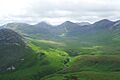
Polladirk Valley: Benbrack and Knockbrack to the left, Benfree (and Benbaun right behind it) (centre left), and Muckanaght (centre right) and Bencullagh (right)
-
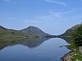
Diamond Hill, viewed from Kylemore Lough in the northeast.
-
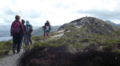
Trail (stone path section) along the final summit ridge of Diamond Hill
-
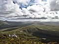
View south from the summit to the boglands of Connemara
-
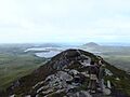
Summit of Diamond Hill and view west, with Tully Mountain (right)


