
Benbreen facts for kids
Quick facts for kids Benbreen |
|
|---|---|
| Binn Braoin | |

Beenbreen, Benbreen Central Top, and Benbreen North Top from the summit of Bencollaghduff. Bengower is the peak at left and back.
|
|
| Highest point | |
| Elevation | 691 m (2,267 ft) |
| Prominence | 186 m (610 ft) |
| Listing | 100 Highest Irish Mountains, Marilyn, Hewitt, Arderin, Simm, Vandeleur-Lynam |
| Naming | |
| English translation | Braon's peak |
| Language of name | Irish |
| Geography | |

Benbreen
Location in Ireland
|
|
| Location | Galway, Ireland |
| Parent range | Twelve Bens |
| OSI/OSNI grid | L7831151547 |
| Topo map | OSi Discovery 37 |
| Geology | |
| Type of rock | Pale quartzites, grits, graphitic top bedrock |
Benbreen is a mountain in Ireland. It stands at 691 metres (2,267 ft) tall. This makes it one of the highest peaks in the country. Benbreen is located in the southern part of the Twelve Bens mountain range. You can find it in the Connemara National Park in Galway, Ireland.
Benbreen is the fourth tallest mountain in the Twelve Bens range. Only Benbaun (729 metres (2,392 ft)), Bencorr (711 metres (2,333 ft)), and Bencollaghduff (696 metres (2,283 ft)) are taller. Unlike a typical pointy mountain, Benbreen looks more like a long, narrow, rocky ridge with several high points.
Contents
What's in a Name?
The name Benbreen comes from the Irish language. It means Binn Braoin, which translates to "Braon's Peak." Experts believe "Braon" might be an old personal name. It is also linked to local family names like "Breen" and "McBreen."
Mountain Shape and Location
The highest point of Benbreen is on the southern end of a long, rocky ridge. This ridge is made of a type of rock called quartzite. Along this ridge, there are two other important peaks:
- Benbreen Central Top (680 metres (2,230 ft))
- Benbreen North Top (674 metres (2,211 ft))
Because of these other peaks, Benbreen looks like a long, high ridge rather than a single peaked mountain. Benbreen is the "South Top" of this ridge.
Benbreen sits between two other mountains: Bencollaghduff to the north and Bengower to the south. The path leading down from Benbreen to Bengower is called Mám na Gaoithe. This means "pass of the wind" in Irish. This area is known for having lots of loose rocks, called scree.
Benbreen is also known as a Marilyn. This is a special term for hills and mountains that rise at least 150 metres (490 ft) above the land around them.
Fun Activities
Hiking and Walking
Benbreen is a popular spot for hikers. Many people climb it as part of a famous route called the Glencoaghan Horseshoe. This challenging walk is about 16 kilometers long and takes 8 to 9 hours to complete. It is considered one of the best high-level hiking routes in Ireland.
Some hikers even take on an even longer route called the Owenglin Horseshoe. This route is about 20 kilometers long and can take 10 to 12 hours. It includes climbing over twelve different mountain peaks!
Rock Climbing
If you like rock climbing, Benbreen has some exciting cliffs on its northeast side. These cliffs offer multi-pitch climbs, which means you climb in sections. The climbs range from 40 to 130 meters long. Some of these climbing routes were first explored in the mid-1980s.
Images for kids
-
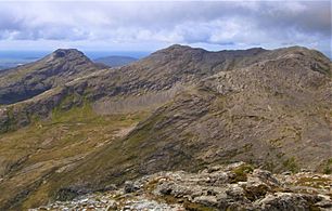
Bengower (left) and Benbreen (right), from the summit of Bencollaghduff
-
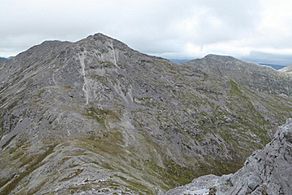
Benbreen and its southern scree slopes, from the summit of Bengower
-
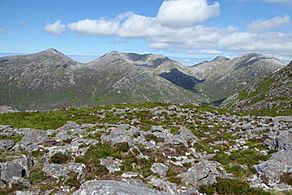
Bengower (left), Benbreen's high summit ridge (centre), and Bencollaghduff (right)
-
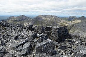
Benbreen's mini-massif and summit ridge, from Bencorr
_and_Benbreen_(right)_from_Bencollaghduff.jpg)


