
Bengower facts for kids
Quick facts for kids Bengower |
|
|---|---|
| Binn Gabhar | |
.jpg)
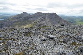
Summit of Bengower viewed from Benbreen
|
|
| Highest point | |
| Elevation | 664 m (2,178 ft) |
| Prominence | 196 m (643 ft) |
| Listing | 100 Highest Irish Mountains, Marilyn, Hewitt, Arderin, Simm, Vandeleur-Lynam |
| Naming | |
| English translation | Goats' Peak |
| Language of name | Irish |
| Geography | |

Bengower
Location in Ireland
|
|
| Location | Galway, Ireland |
| Parent range | Twelve Bens |
| OSI/OSNI grid | L7830150644 |
| Topo map | OSi Discovery 37 |
| Geology | |
| Type of rock | Pale quartzites, grits, graphitic bedrock |
Bengower is a mountain in County Galway, Ireland. It stands at 664 metres (2,178 ft) tall. This makes it one of the higher peaks in Ireland. Bengower is part of the Twelve Bens mountain range. You can find it in the Connemara National Park. It is the sixth tallest of the main Twelve Bens mountains.
Contents
What Does Bengower Mean?
The name Bengower comes from the Irish language. It means "Goats' Peak" (Binn Gabhar). No one is quite sure why it's called "Goats' Peak." Maybe goats used to live there! Sometimes, maps have mistakenly called it "Glengower."
Where is Bengower Located?
Bengower is surrounded by other mountains. To its north is Benbreen, which is 691 metres (2,267 ft) high. To the south, you'll find Benlettery (577 metres (1,893 ft)) and Benglenisky (517 metres (1,696 ft)).
Climbing Bengower from the north can be a bit tricky. There's a rocky ridge that needs some scrambling. This means you might need to use your hands to climb. This ridge starts from a pass called Mám na Gaoithe. That means "pass of the wind" in Irish.
Bengower is also known as a "Marilyn." This is a special term for mountains that stand out. A mountain is a Marilyn if its top is at least 100 metres (330 ft) higher than the land around it. Bengower's top is 196 metres (643 ft) higher than the land around it.
Exploring Bengower: Hill Walking
Many people enjoy hiking up Bengower. There are a few popular ways to do it.
Shorter Loops
A common way to climb Bengower is a 7-kilometre loop. This walk takes about 3 to 4 hours. It includes Bengower and its nearby peaks, Benlettery and Benglenisky. It's a great way to see several mountains in one trip.
Longer Mountain Adventures
Bengower is also part of a famous long-distance hike. This hike is called the Glencoaghan Horseshoe. It's about 16 kilometres long and takes 8 to 9 hours. Many people think it's one of the best hill-walks in Ireland.
Another even longer route is the Owenglin Horseshoe. This one is 20 kilometres long and can take 10 to 12 hours. It goes around the Owenglin River and includes more than twelve mountain tops!
Gallery
-
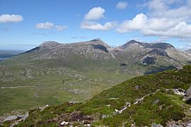
Benlettery (left), Bengower, and Benbreen (right), viewed from south ridge Derryclare
-
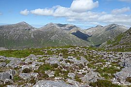
Bengower (left), Benbreen (centre), and Bencollaghduff (right), viewed Derryclare
-
Bengower (back left) behind Benbreen, viewed from Bencollaghduff
-
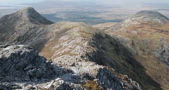
Benlettery (left) and Benglenisky (right) from the summit of Bengower


_and_Benglenisky_(right)_from_Bengower.jpg)
