
Benglenisky facts for kids
Quick facts for kids Benglenisky |
|
|---|---|
| Binn Ghleann Uisce | |
_and_Benglenisky_(right)_from_Ballynahinch_River.jpg)
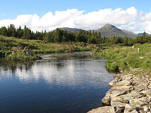
Benglenisky (left), and Benlettery (centre), from the Ballynahinch Castle fishery
|
|
| Highest point | |
| Elevation | 516 m (1,693 ft) |
| Prominence | 48 m (157 ft) |
| Listing | Arderin |
| Naming | |
| English translation | Peak of the Wet Hillsides |
| Language of name | Irish |
| Geography | |

Benglenisky
Location in Ireland
|
|
| Location | Galway, Ireland |
| Parent range | Twelve Bens |
| OSI/OSNI grid | L7661650065 |
| Topo map | OSi Discovery 37 |
| Geology | |
| Type of rock | Pale quartzites, grits, graphitic bedrock |
Benglenisky is a mountain in Ireland. It stands at 516 meters (about 1,693 feet) tall. This makes it the 368th highest peak in Ireland on the Arderin scale.
Benglenisky is part of the Twelve Bens mountain range. It is located in the Connemara National Park in Galway, Ireland. It is the second most southern peak in the range, next to Benlettery. Benglenisky is also the lowest of the main Twelve Bens mountains.
What's in a Name?
The name Benglenisky comes from the Irish language. It means "Peak of the Glen of the Water." This name likely comes from a valley, or glen, on the mountain's southeast side.
Some people in the area call Benglenisky by other names. On its northwest side, it is known as Binn Dubh, which means "Black Peak." It is also called Cnoc Dubh, meaning "Black Hill."
Near Benglenisky, in a place called Barr na nÓrán, you can find green Connemara marble. People started digging for this special marble way back in the 1820s.
Where is Benglenisky?
Benglenisky is the second most southern mountain in the Twelve Bens range. It is located on the western edge of these mountains. Its neighbor, Benlettery, is slightly taller at 577 meters (about 1,893 feet).
Benglenisky is connected to another mountain called Bengower (664 meters or 2,178 feet). A high ridge, like a natural pathway, links them. This ridge also connects Benlettery to Bengower.
Benglenisky is not part of the main group of six Bens that form a horseshoe shape. This horseshoe goes around the Glencoaghan River valley. Because of this, fewer people visit Benglenisky.
Even though it's the lowest of the main Twelve Bens, Benglenisky offers beautiful views. It often appears as a scenic background for Ballynahinch Castle and Ballynahinch Lake. However, its neighbor, Benlettery, often gets more attention because of its striking pyramid shape.
Climbing Benglenisky
Benglenisky is easy to reach, making it a good mountain for a climb. You can hike it by itself. This walk is about 5 kilometers (3 miles) long and takes 2 to 3 hours. You can start and finish at the Ben Lettery An Oige youth hostel.
Many hikers also climb Benglenisky as part of a longer trip. It can be combined with Bengower and Benlettery. This loop walk is about 7 kilometers (4.3 miles) long and takes 3 to 4 hours.
Benglenisky is not on the route of the famous Glencoaghan Horseshoe walk. That walk is much longer, about 16 kilometers (10 miles), and takes 8 to 9 hours. It's considered one of Ireland's best hill-walks. There's an even longer route called the Owenglin Horseshoe, which is 20 kilometers (12.4 miles) and takes 10 to 12 hours.
Images for kids
-
Benlettery (right) and Benglenisky (left), from the Owenmore River
-
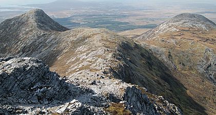
Benlettery (left) and Benglenisky (right) from summit of Bengower


_and_Benglenisky_(right)_from_Bengower.jpg)
