
Benlettery facts for kids
Quick facts for kids Benlettery |
|
|---|---|
| Binn Leitrí | |

Benlettery behind the Ballynahinch Castle fishery
|
|
| Highest point | |
| Elevation | 577 m (1,893 ft) |
| Prominence | 62 m (203 ft) |
| Listing | Arderin |
| Naming | |
| English translation | Peak of the Wet Hillsides |
| Language of name | Irish |
| Geography | |

Benlettery
Location in Ireland
|
|
| Location | Galway, Ireland |
| Parent range | Twelve Bens |
| OSI/OSNI grid | L7754649537 |
| Topo map | OSi Discovery 44 |
| Geology | |
| Type of rock | Pale quartzites, grits, graphitic bedrock |
Benlettery is a mountain in Ireland. It stands at 557 meters (about 1,827 feet) tall. This makes it the 259th highest peak in Ireland.
Benlettery is located in County Galway, in the western part of Ireland. It is part of the famous Twelve Bens mountain range. This range is found within the beautiful Connemara National Park. Benlettery is the southernmost mountain in this range. It is also the 11th tallest of the main Twelve Bens peaks.
On the southern side of Benlettery, you can find the Ben Lettery An Oige youth hostel. This hostel is a great place for hikers and travelers to stay. It is located just off the N59 road that leads to Clifden.
Contents
What's in a Name?
The name Benlettery comes from the Irish words Binn Leitrí. This means "Peak of the Wet Hillsides." This name makes sense because the mountain's southern slope is called Lettery, which also means "wet hillsides."
Long ago, in 1684, another name for the mountain was recorded. It was called Bindowglass or "Bendouglas." This name comes from the Irish Binn Dúghlais, meaning "peak of the black stream." An old story says there was a special pool of water on the mountain's top. If you washed your hair in it, it would turn white!
Where is Benlettery?
Benlettery is the mountain furthest south in the Twelve Bens range. It sits on the western edge of this mountain group. A high ridge connects Benlettery to another peak called Bengower, which is 664 meters tall. This ridge also links to Benglenisky, a 516-meter peak.
Benlettery is one of six mountains that form a big horseshoe shape. This shape surrounds the valley of the Glencoaghan River. This area is known as the Glencoaghan Horseshoe.
Even though Benlettery is not as tall as some other Bens (it's under 600 meters), it's very famous. Its location at the southern end of the range is special. From the south, it looks like a pyramid. This makes it a beautiful background for places like Ballynahinch Castle and Ballynahinch Lake.
The Ben Lettery Connemara Youth Hostel
On the southern slopes of Benlettery, you'll find the "Ben Lettery Connemara Youth Hostel." This hostel has 40 beds for visitors. It is run by An Oige, which is like the Irish Youth Hostels Association.
This hostel is very popular. Outside.ie magazine even listed it as one of the top ten An Oige youth hostels in all of Ireland. It's a great spot for young adventurers to start their mountain explorations.
Hiking Benlettery
Benlettery is a popular mountain for hikers. It's easy to get to, especially from the Ben Lettery An Oige youth hostel.
You can climb Benlettery on its own. This hike is about 5 kilometers long and takes 2 to 3 hours. It's a good choice for a shorter adventure.
Many hikers also combine Benlettery with other peaks. You can do a 7-kilometer loop walk with Bengower and Benglenisky. This takes about 3 to 4 hours.
For more experienced hikers, Benlettery is part of two longer routes:
- The Glencoaghan Horseshoe: This is a 16-kilometer hike that takes 8 to 9 hours. It's known as one of Ireland's best hill-walks.
- The Owenglin Horseshoe: This is an even longer route, about 20 kilometers. It takes 10 to 12 hours and includes more than twelve mountain tops!
Gallery
-
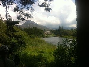
Benlettery behind Ballynahinch Castle
-
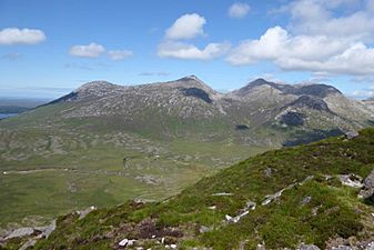
Benlettery (left), Bengower (middle), Benbreen (right), from Derryclare
-
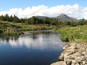
Benlettery (right) and Benglenisky (left), from the Owenmore River
-
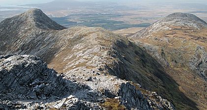
Benlettery (left) and Benglenisky (right) from summit of Bengower
.jpg)


_and_Benglenisky_(right)_from_Bengower.jpg)
