
Doo Lough (Mayo) facts for kids
Quick facts for kids Doo Lough |
|
|---|---|

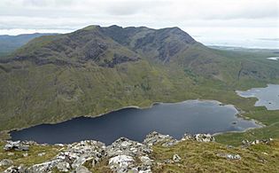
Looking southeast to the massif of Ben Gorm (centre left), and slopes of Ben Lugmore (right)
|
|

Location in island of Ireland
|
|
| Location | County Mayo |
| Coordinates | 53°39′9″N 9°45′49″W / 53.65250°N 9.76361°W |
| Native name | Dúloch Error {{native name checker}}: parameter value is malformed (help) |
| Primary inflows | Glencullin Lough |
| Primary outflows | Owengarr River |
| Catchment area | 27.52 km2 (10.6 sq mi) |
| Basin countries | Ireland |
| Max. length | 3.5 km (2.2 mi) |
| Max. width | 0.75 km (0.5 mi) |
| Surface area | 1.55 km2 (0.60 sq mi) |
| Max. depth | 46 m (151 ft) |
| Surface elevation | 30 m (98 ft) |
Doo Lough (Irish: Dúloch, meaning Black Lake) is a beautiful freshwater lake in the west of Ireland. It is located in southwest County Mayo on the Murrisk peninsula. This area is known for its stunning natural beauty and tall mountains.
Contents
Exploring Doo Lough's Location
Doo Lough is about 4 kilometers (2.5 miles) long and 1 kilometer (0.6 miles) wide. It lies about 30 kilometers (19 miles) southwest of Westport. You can find it near the small village of Delphi. The lake stretches in a narrow shape from northwest to southeast.
Mountains Around the Lake
Tall mountains surround Doo Lough. On its southwest side, you'll see the long ridge of Ben Lugmore, which is about 803 meters (2,635 feet) high. On the northeast side is Barrclashcame, standing at about 772 meters (2,533 feet). At the southeast end of the lake, you'll find the large Ben Gorm mountain, about 700 meters (2,300 feet) tall.
The Lug More Corrie
At the northwestern end of Doo Lough, there's a deep, bowl-shaped valley called a corrie. This one is known as Lug More (or Irish: Coum Dubh). The Glencullin River flows from this corrie into a nearby lake called Lough Glencullin.
The corrie is surrounded by the long ridge of Ben Lugmore. This ridge has several smaller peaks, including Ben Lugmore East Top and Ben Lugmore West Top, both about 790 meters (2,592 feet) high. A green, grassy path called The Ramp cuts across the corrie's wall. Climbers use this path to reach the Ben Lugmore ridge from the shores of Doo Lough.
How Water Flows Through Doo Lough
Doo Lough is part of a group of connected lakes near Delphi. Water from Glencullin Lough flows into Doo Lough. Then, the water from Doo Lough flows into Fin Lough through the Owengarr River. Finally, Fin Lough drains into Killary Harbour through the Bundorragha River. It's like a natural water system connecting these beautiful spots!
Animals and Nature in Doo Lough
Doo Lough is home to many different types of fish. You can find brown trout, sea trout, perch, and salmon here. There are also Arctic char, three-spined stickleback, and the critically endangered European eel.
The lake is part of a special protected area called the Mweelrea/Sheeffry/Erriff Complex Special Area of Conservation. This means the area's nature and wildlife are protected to keep them healthy and thriving.
The Famine Memorial
At the northern end of Doo Lough, there is a stone Celtic cross. This cross was put there as a memorial to a sad event from 1849, known as the Doolough Tragedy. It reminds people of the difficult times during the Great Famine in Ireland.
Gallery
-
The full ridge of Ben Lugmore, seen from across Doo Lough, on Barrclashcame
-
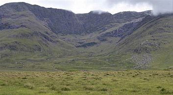
Looking into the corrie of Lug More (Irish: Coum Dubh), and the headwall of Ben Lugmore, with The Ramp running diagonally across the face.
-
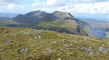
Mweelrea (back left), and Ben Lugmore (centre), and Doo Lough (right), from the summit of Ben Gorm
-
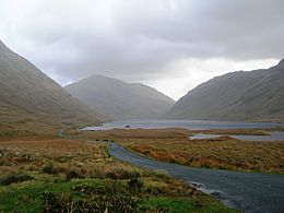
Looking southeast from the top of Doo Lough towards the massif of Ben Gorm
-
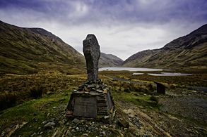
The Famine Memorial at Doo Lough

_from_Doo_Lough_Pass_(Glencullin_Valley)_1.jpg)
,_and_Ben_Lugmore_(centre),_from_summit_of_Ben_Gorm.jpg)


