Barrclashcame facts for kids
Quick facts for kids Barrclashcame |
|
|---|---|
| Barr Chlais Céim | |

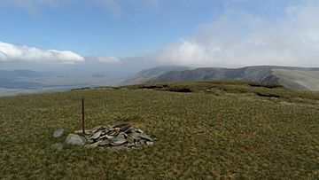
Cairn at the summit of Barrclashcame
|
|
| Highest point | |
| Elevation | 772 m (2,533 ft) |
| Prominence | 707 m (2,320 ft) |
| Listing | P600, Hewitt, Marilyn |
| Naming | |
| English translation | top of Clais Céim |
| Language of name | Irish |
| Geography | |
| Location | County Mayo, Republic of Ireland |
| Parent range | Sheeffry Hills |
| OSI/OSNI grid | L849695 |
Barrclashcame is a tall mountain located in County Mayo, Ireland. It stands 772 meters (2,533 feet) high. Its name comes from the Irish language, Barr Chlais Céim, which means "top of Clais Céim".
Where is Barrclashcame Located?
Barrclashcame is found in a place called the townland of Clashcame. It is the very highest point in the Sheeffry Hills. These hills are a mountain range in County Mayo.
What is Around Barrclashcame?
Close to Barrclashcame, towards the northwest, you can find another peak. This peak is called Barrclashcame Northwest or Storikeennageer. It is 580 meters high. To the northeast, there is Tievummera, which is 762 meters tall.
The mountain also looks over some beautiful lakes and valleys. To the south and west, you can see Doo Lough, Glencullin, and Glenummera. These areas help separate Barrclashcame from other famous mountains. These include Mweelrea and Ben Gorm.
 | Shirley Ann Jackson |
 | Garett Morgan |
 | J. Ernest Wilkins Jr. |
 | Elijah McCoy |


