
Sheeffry Hills facts for kids
Quick facts for kids Sheeffry Hills |
|
|---|---|
| Irish: Cnoic Shíofra | |

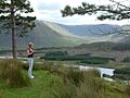
Sheeffry Hills from Sheeffry Bridge
|
|
| Highest point | |
| Peak | Barrclashcame |
| Elevation | 772 m (2,533 ft) |
| Geography | |

Sheeffry Hills
Location in island of Ireland
|
|
| Country | Republic of Ireland |
| Provinces of Ireland | Connacht |
The Sheeffry Hills or Sheeffry Mountains are a group of hills located in County Mayo, Ireland. In the Irish language, they are called Cnoic Shíofra, which means "hills of the wraith." These hills are surrounded by different natural features. To the west, you'll find Glencullin Lough and Doo Lough. To the south, there's Glenummera and Tawnyard Lough. The Owenmore Glen is to the east, and the Bunowen River is to the north.
Contents
Exploring the Sheeffry Hills
The Sheeffry Hills are a great place to explore the natural beauty of Ireland. They offer stunning views and a chance to see different types of landscapes, from high peaks to calm lakes.
High Peaks and Their Names
The tallest point in the Sheeffry Hills is a peak called Barrclashcame. It stands at an impressive 772 meters (about 2,533 feet) above sea level. But Barrclashcame isn't the only important peak here.
Other notable peaks in the range include:
- Barrclashcame Northwest, also known as Storikeennageer, which is 580 meters high.
- Tievummera, standing at 762 meters.
- Tievnabinnia, reaching 742 meters.
- Tawnyard, which is 436 meters tall.
- Tawnyrower, with a height of 510 meters.
These peaks stretch from the west to the east of the hill range.
Lakes Within the Hills
There are several beautiful lakes, known as loughs in Ireland, located within the Sheeffry Hills. These loughs add to the scenic beauty of the area.
The two largest loughs are:
- Lugacolliwee
- Lugaloughan
Other loughs you can find here include:
- Lough Awaniareen
- Lough Allisheen
- Lough Tariff
- Lough Brawn
- Lugalough
These lakes are important parts of the local environment.
Nearby Villages and History
Around the Sheeffry Hills, you can find several small communities and villages. These places offer a glimpse into local life.
Some of the settlements in the area are:
- Drummin and Carrowkennedy, located to the east of the hills.
- Cregganbaun, found to the west.
- Delphi, situated to the south.
Carrowkennedy is also known for a historical event that took place there in June 1921.
Images for kids
-
Sheeffry Hills

