
Ben Lugmore facts for kids
Quick facts for kids Ben Lugmore |
|
|---|---|
| Binn Log Mhór | |
_Ireland.jpg)
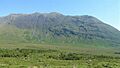
Looking east to summit of Ben Lugmore, with the cliffs of Lug More (Irish: Coum Dubh) corrie (left)
|
|
| Highest point | |
| Elevation | 803 m (2,635 ft) |
| Prominence | 158 m (518 ft) |
| Listing | 100 Highest Irish Mountains, Marilyn, Hewitt, Arderin, Simm, Vandeleur-Lynam |
| Naming | |
| English translation | peak of the big hollow |
| Language of name | Irish |
| Geography | |

Ben Lugmore
Location in Ireland
|
|
| Location | Mayo, Ireland |
| Parent range | Mweelrea |
| OSI/OSNI grid | L8117367379 |
| Topo map | OSi Discovery 37 |
| Geology | |
| Type of rock | Sandstone & conglomerate, ignimbrite bedrock. |
| Climbing | |
| Normal route | via The Ramp in the Irish: Coum Dubh |
Ben Lugmore (which means "peak of the big hollow" in Irish) is a tall mountain in Ireland. It stands at 803 meters (about 2,635 feet) high. This makes it the 29th-highest peak in Ireland on one list (the Arderin scale). It's also the 37th-highest on another list (the Vandeleur-Lynam scale).
Ben Lugmore is part of a group of mountains shaped like a horseshoe. This group includes Mweelrea, which is even taller at 814 meters (about 2,671 feet). Mweelrea is the highest mountain in the Irish area called Connacht. This mountain range is found in Mayo, between Killary Harbour and Doo Lough.
The mountain is famous for its long top ridge. This ridge forms a deep, cliff-lined bowl-shaped valley called a corrie. This corrie is known as Lug More (or Irish: Coum Dubh). Inside this corrie, there's a special path called The Ramp. Climbers use The Ramp to get to the top ridge. You can hike to the summit in about 3 hours from the corrie below. Many people also climb it as part of the longer 6-7 hour "Mweelrea Horseshoe" walk. This longer walk is considered one of Ireland's best mountain hikes.
Contents
What's in a Name?
The name "Ben Lugmore" comes from the Irish words Binn Log Mhór. This means "peak of the big hollow". It describes the deep, bowl-shaped valley (or corrie) on the northeast side of the mountain. This corrie is called Lug More.
An Irish expert named Paul Tempan explained this meaning. Another writer, Patrick Weston Joyce, noted that "Lugmore" (meaning "Great Hollow") is part of several other Irish place names. You can find more details about these names in the Placenames Database of Ireland.
Mountain Rocks
The rocks that make up Ben Lugmore are part of something called the "Mweelrea Formation." These rocks are quite different from those found in the Twelve Bens mountains nearby.
Basically, the Mweelrea Formation is made of Ordovician period sandstones. These sandstones were formed from huge fan-shaped piles of sediment called alluvial fans. These fans were laid down by ancient rivers. Mixed in with these sandstones are layers of ash. This ash came from volcanoes that were active during the Ordovician period, a very long time ago!
Where is Ben Lugmore?
Ben Lugmore is located on the northern side of the horseshoe-shaped massif of the Mweelrea Mountains. To the south, you'll find Killary Harbour, which is Ireland's deepest fjord (a long, narrow sea inlet). To the north is Doo Lough. Mweelrea, the highest point in the Irish province of Connacht, sits at the top of this horseshoe shape.
Ben Lugmore has a small, sharp top that feels "airy" because it's on a high, narrow ridge. This ridge connects to Ben Bury and then continues on to Mweelrea. Along this ridge, there are two other high peaks that are almost the same height as Ben Lugmore:
- Ben Lugmore West Top is 790 meters (about 2,592 feet) tall.
- Ben Lugmore East Top is also 790 meters (about 2,592 feet) tall.
From a distance, Ben Lugmore looks like a long, sharp ridge with its different peaks dotted along it.
To the northeast of Ben Lugmore's ridge are the cliffs of the deep corrie called Lug More (also known as Irish: Coum Dubh). This corrie looks down into a small valley called Glencullin. To the southwest of the ridge is the Glenconnelly valley. Here, the high cliffs of Ben Lugmore West Top, Benbury, and Mweelrea form a circle around a lake called Lough Bellawaum.
Ben Lugmore is also important because of its "prominence" (how much it rises above the land around it). Its prominence of 158 meters (about 518 feet) means it's a Marilyn. It's also listed as the 18th-highest mountain in Ireland on the MountainViews Online Database of the "100 Highest Irish Mountains."
Fun Activities
Hiking the Hills
The quickest way to reach the top of Ben Lugmore is a 3-hour hike. This route is about 6 kilometers (3.7 miles) long and goes through the Lug More (or Irish: Coum Dubh) corrie and the Glencullin valley. A special feature on this route is The Ramp. This path crosses the corrie's headwall, sloping upwards from east to west. It leads you to the ridge of Ben Lugmore. It's important to find The Ramp carefully, as the corrie has many cliffs.
You can also make this hike longer, turning it into a 6-hour, 13-kilometer (8-mile) trip. This longer route includes climbing the extra peaks of Ben Bury and Mweelrea.
Ben Lugmore is also part of the famous Mweelrea Horseshoe walk. This hike is about 15 kilometers (9.3 miles) long and takes 6-7 hours. It's considered one of the "top three" mountain walks in Ireland! The walk starts and ends at the Delphi Mountain Resort. It takes you over all the peaks in the Mweelrea mountain group, including Ben Lugmore and its smaller peaks, Ben Bury, and Mweelrea.
Rock Climbing
The high cliffs on the northeast side of Ben Lugmore are a popular spot for rock climbing. These cliffs form the upper part of the Lug More (or Irish: Coum Dubh) corrie, above The Ramp. There are many climbing routes here, ranging from easy to moderately difficult. Some of these climbs are 35 to 70 meters (115 to 230 feet) long. Some of the first climbs here were done in the mid-1950s. They often follow natural cracks and gullies between the different peaks of Ben Lugmore.
For more challenging climbs, you can go to the Doo Lough Crags. These are located at the southern entrance to the corrie. The routes here are 30 to 70 meters (98 to 230 feet) long. They are on sandstone and conglomerate rock (a type of rock made of pebbles). These climbs are rated from very severe to extreme. Some well-known climbs include Bragela's Watch (100m), Red Dawn (25m), and Letter to Breshnev (30m). Most of the best routes were created in the late 1980s and early 1990s.
Winter Climbing
When winter arrives, the Lug More (or Irish: Coum Dubh) corrie also offers several ice climbing routes. The most famous one is Recession Gully. It's a challenging climb, about 400 meters (1,312 feet) long.
Images for kids
-
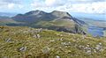
Mweelrea (back left), and Ben Lugmore (centre), viewed from the east on the summit of Ben Gorm
-
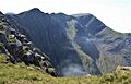
Northeast face of Ben Lugmore, and Lug More corrie, with The Ramp (green, in sunlight) crossing it, viewed from east spur of Ben Lugmore
-
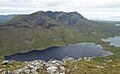
Full ridge of Ben Lugmore and Lug More corrie, viewed from across Doo Lough, on Barrclashcame
-
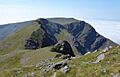
Ben Lugmore West Top, and Ben Bury (back right), viewed from Ben Lugmore
-
Ben Lugmore southwest face, viewed from the Glenconnelly valley
,_and_Ben_Lugmore_(centre),_from_summit_of_Ben_Gorm.jpg)


_from_summit_of_Ben_Lugmore.jpg)
.jpg)
