
Carlingford Lough facts for kids
Quick facts for kids Carlingford LoughLoch Cairlinn Carlinford / Cairlinfurd Loch |
|
|---|---|

Carlingford Lough
|
|

Carlingford Lough
Loch Cairlinn Carlinford / Cairlinfurd Loch Location in Ireland
|
|
| Location | Republic of Ireland – United Kingdom border |
| Coordinates | 54°04′24″N 6°11′58″W / 54.07329°N 6.19938°W |
| River sources | Newry River, Newry Canal |
| Ocean/sea sources | Irish Sea |
| Basin countries | Northern Ireland, Republic of Ireland |
| Salinity | 31.31–33.99 psu |
| Settlements | Carlingford, Greencastle, Greenore, Killowen, Newry, Omeath, Rostrevor, Warrenpoint |
| Designated: | 9 March 1998 |
| Reference #: | 936 |
Carlingford Lough (Irish: Loch Cairlinn) is a beautiful sea inlet, like a long, narrow arm of the sea. It was formed by glaciers long ago. This lough forms part of the border between Northern Ireland to the north and the Republic of Ireland to the south.
On its northern side is County Down, and on its southern side is County Louth. The Newry River and Newry Canal flow into its northwest corner. The name Carlingford comes from an old Viking language, meaning "narrow sea-inlet of the hag". In Irish, it used to be called Cuan Snámh-Aighneach.
Contents
What is Carlingford Lough?
Carlingford Lough is a special type of sea inlet called a fjord. It was carved out by huge glaciers during the Ice Age. It is one of only three glacial fjords in Ireland. The other two are Lough Swilly and Killary Harbour.
The Newry River and Newry Canal connect the lough to the city of Newry. The canal even continues towards the River Bann and Lough Neagh.
Towns and Mountains Around the Lough
On the northern coast, in County Down, you'll find the towns of Warrenpoint and Rostrevor. Behind them rise the impressive Mourne Mountains.
On the southern coast, in County Louth, are the towns of Omeath, Carlingford, and Greenore. These towns are on the Cooley Peninsula, backed by the Cooley Mountains.
Visiting Carlingford Lough
This area has been a popular place for visitors for a very long time. People started coming here in Victorian times, especially after the railway between Dublin and Belfast opened.
It's located about halfway between these two big cities, making it easy to reach. Its beautiful scenery and sheltered waters still make it a favorite spot for tourists today.
Animals and Plants
The northern shores of Carlingford Lough have large areas of mudflats and salt marshes. These muddy areas are important feeding grounds in winter for birds like the pale-bellied brent goose.
Near the mouth of the lough, there are small islands made of rock and shingle. These islands are nesting spots for terns, which are seabirds that hunt for fish in the shallow waters.

Protected Areas
Carlingford Lough is recognized as an Important Bird Area. This means it's a very important place for many different kinds of birds.
It is also a Ramsar site, which means it's a wetland of international importance. This special protection helps to keep the lough healthy for its wildlife. The Ramsar site covers 830.51 hectares and was designated on March 9, 1998.
Why is it Protected?
The lough is protected because it supports many important bird species. Some of these birds are vulnerable or endangered in Ireland.
- It has important breeding populations of common terns.
- Roseate terns, which are quite rare, have also returned to breed here.
- It has supported important numbers of Arctic terns.
- It's also a crucial place for Sandwich terns to breed.
- Many brent geese spend the winter here, making it an internationally important spot for them.
Getting Around
Trains
The closest train station is Newry. It's on the main railway line that connects Dublin and Belfast. You can catch the Enterprise train service here.
Years ago, there was a railway line along the southern side of the lough, but it closed in the 1950s. Parts of that old railway line are now used as a walking and cycling path called the Carlingford Lough greenway.
Boats and Harbours
Carlingford Lough is deep enough for boats to travel on. The entrance from the sea is marked by the Haulbowline Lighthouse, which was built in 1824.
There's a large cargo port at Greenore where big ships can load and unload goods. There's also a smaller fishing harbour at Carlingford. A modern marina for leisure boats is located north of Carlingford town.
Images for kids
-
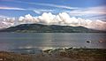
Carlingford Lough looking towards the Mournes

See also
 In Spanish: Carlingford Lough para niños
