
Mourne Mountains facts for kids
Quick facts for kids Mourne Mountains |
|
|---|---|
| Beanna Boirche | |

View of the Mournes from St John's Point, County Down
|
|
| Highest point | |
| Peak | Slieve Donard |
| Elevation | 850 m (2,790 ft) |
| Geography | |

Location in Northern Ireland

Location in island of Ireland
|
|
| Sovereign state | United Kingdom |
| Constituent country | Northern Ireland |
| Counties | County Down |
| Range coordinates | 54°10′N 6°05′W / 54.167°N 6.083°W |
| Geology | |
| Type of rock | Granite |
The Mourne Mountains (pronounced MORN) are a beautiful granite mountain range in County Down, located in the south-east of Northern Ireland. They are also known as the Mournes or Mountains of Mourne. These mountains are home to the highest peaks in Northern Ireland, with Slieve Donard being the tallest at 850 meters (2,789 feet) high.
The Mournes are recognized as an Area of Outstanding Natural Beauty. There's even a plan to make them Northern Ireland's first national park! Part of this special area is looked after by the National Trust, and many people visit the Mournes every year. A famous stone wall, called the Mourne Wall, crosses fifteen of the mountain tops. It was built to protect the water supply for the Silent Valley and Ben Crom reservoirs.
Contents
Exploring the Mourne Mountains

The name 'Mourne' comes from an old Gaelic family or clan called the Múghdhorna. The Irish name for the mountains, na Beanna Boirche, might mean "the peaks of the peak district" or "peaks of Boirche," who was a mythical king.
Many mountains here have names starting with "Slieve," like Slieve Donard and Slieve Binnian. "Slieve" comes from the Irish word sliabh, which means "mountain." You'll also find some really interesting names, such as Pigeon Rock, Buzzard's Roost, and the Devil's Coach Road!
On a clear day, you can even see the Mourne Mountains all the way from the Isle of Man and Dublin!
Tallest Peaks in the Mournes
Here are some of the highest and most well-known mountains in the Mournes:
| Rank | Name | Irish name | Translation | Elevation |
|---|---|---|---|---|
| 1 | Slieve Donard Highest in Ulster |
Sliabh Dónairt | Domhanghart's mountain | 850 m (2,789 ft) |
| 2 | Slieve Commedagh | Sliabh Coimhéideach | guarding/watching mountain | 767 m (2,516 ft) |
| 3 | Slieve Binnian | Sliabh Binneáin | mountain of the little peaks | 746 m (2,448 ft) |
| 4 | Slieve Bearnagh | Sliabh Bearnach | gapped mountain | 739 m (2,425 ft) |
| 5 | Slieve Lamagan | Sliabh Lámhagáin | crawling/creeping mountain | 704 m (2,310 ft) |
| 6 | Slieve Meelbeg | Sliabh Míol Beag | small mountain of the ants | 708 m (2,323 ft) |
| 7 | Slieve Meelmore | Sliabh Míol Mór | great mountain of the ants | 680 m (2,231 ft) |
| 8 | Slieve Muck | Sliabh Muc | pig mountain | 670 m (2,198 ft) |
There are many more mountains and hills in the Mourne range, each with its own unique features and views!
Other Cool Features
The Mourne Mountains offer more than just peaks. They have interesting walls, forests, and reservoirs to explore.
The Famous Mourne Wall

The Mourne Wall is a very long dry stone wall, meaning it's built without mortar. It stretches for 31.4 kilometers (19.5 miles) and crosses fifteen mountain tops! It was built to protect the water collection area bought by the Belfast Water Commissioners in the late 1800s. This was to make sure the growing city of Belfast had enough clean water.
Building the Mourne Wall was a huge project. It started in 1904 and took 18 years to finish, finally completed in 1922. The wall is now a protected historic building.
Wonderful Forests
_-_geograph.org.uk_-_830551.jpg)
- Tollymore Forest Park: This park is near Newcastle and covers a large area of 630 hectares (1,600 acres) at the foot of the Mourne Mountains. It has amazing views of the mountains and the sea. The Shimna River flows through the park, with 16 bridges crossing it, some very old! The river is important for salmon and trout and is a special scientific area. You can find four walking trails here, with the longest being 13 km (8 miles).
- Donard Forest: Also near Newcastle, this forest borders Donard Park. The Glen River runs through it, crossed by three stone bridges.
- Rostrevor Forest: Located near Rostrevor village, this forest sits between the Mourne Mountains and Carlingford Lough. Trees like sitka spruce and pine were first planted here in 1931.
Important Reservoirs

All the water reservoirs in the Mournes are managed by Northern Ireland Water. They are vital for supplying water to homes and businesses.
- Silent Valley Reservoir: This large reservoir is near Kilkeel. It provides most of the water for County Down, nearby counties, and much of Belfast. It was built between 1923 and 1933 by over a thousand workers.
- Ben Crom Reservoir: Located upstream from Silent Valley, this reservoir also helps supply water to the region. It was built between 1953 and 1957.
- Spelga Reservoir: Found near Hilltown in the north-west Mournes, Spelga Dam created this reservoir. It sits high up at over 370 meters (1,200 feet) above sea level and was built between 1953 and 1957.
Plants and Animals of the Mournes
The Mournes are home to various plants and animals adapted to mountain life.
- Plants: Besides grasses, you'll mostly see heathers and gorse. There are three types of heather: cross-leaved, bell, and common heather. Two types of gorse are also found: common gorse and western gorse. Other plants include common cottongrass, roseroot, and wild thyme.
- Animals: Sheep graze high up in the mountains. Many birds live here, such as the raven, peregrine falcon, buzzard, and stonechat. Sadly, the golden eagle, which used to live here, hasn't been seen in the Mournes since 1836.
Protecting the Mournes

In 1993, the National Trust bought almost 1,300 acres (5.3 square kilometers) of land in the Mournes. This included parts of Slieve Donard and Slieve Commedagh, the two highest mountains.
There's a big idea to make the Mourne Mountains Northern Ireland's first national park. This plan has caused some discussion because much of the land is privately owned by over 1,000 farmers. People also worry about how it might affect local communities and house prices.
Fun Activities in the Mournes

The Mourne Mountains are a fantastic place for outdoor activities! "Discover Northern Ireland" promotes the area for its hiking trails and amazing views of forests and the coastline.
- Hiking and Walking: This is the most popular activity, with nearly three-quarters of visitors coming to walk or hike.
- Challenges: You can try the Mourne Wall challenge, also called the 7-peak challenge, which covers seven of the highest mountains. There's also the Mourne six-peak challenge, where hikers climb six major peaks over three days.
- Other Activities: You can also enjoy forest and beach walks, cycling, and rock climbing. The Mournes have many granite cliffs and tors, making it a top spot for climbers since the 1930s.
Most visitors to the Mournes are from Northern Ireland itself, and many come for a single day trip.
Wind Farm Proposal
Since 2015, a company called ABO Wind has wanted to build a wind farm in the western Mourne Mountains. They want to build eight huge turbines, each 142 meters (466 feet) tall. These would be some of the tallest structures in Ireland. The company says these turbines could power many homes.
However, there's a lot of opposition because the wind farm would be in an Area of Outstanding Natural Beauty. People are worried about the impact on wildlife and habitats. A local group, Mourne AONB Against Windfarms, warns that this could lead to more wind farms being built in protected areas.
Images for kids
-
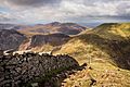
The Mourne Wall on Slieve Donard, looking west

See also
 In Spanish: Montes de Mourne para niños
