
Slieve Donard facts for kids
Quick facts for kids Slieve Donard |
|
|---|---|
| Sliabh Dónairt | |
.JPG)
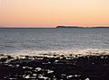
Slieve Donard and Newcastle from Murlough Beach
|
|
| Highest point | |
| Elevation | 850 m (2,790 ft) |
| Prominence | 822 m (2,697 ft) |
| Listing | County High Point (Down), P600, Marilyn, Hewitt, Arderin, Simm, Vandeleur-Lynam |
| Naming | |
| English translation | Dónairt's mountain |
| Language of name | Irish |
| Geography | |

Location in Northern Ireland

Location in County Down

Location in island of Ireland

Location in the United Kingdom
|
|
| Location | County Down, Northern Ireland |
| Parent range | Mournes |
| OSI/OSNI grid | J357276 |
| Topo map | OSNI Discoverer 29 |
| Geology | |
| Mountain type | Granite granophyre Bedrock |
Slieve Donard (pronounced SLEEV-_-DON-ərd) is the tallest mountain in Northern Ireland. It is also the highest mountain in the wider area of Ulster. Standing at 850 metres (2,790 ft) (about 2,789 feet) tall, it is part of the Mourne Mountains.
This impressive peak is located near the town of Newcastle. It sits on the eastern coast of County Down, looking out over the Irish Sea. Slieve Donard is also the seventh highest mountain on the entire island of Ireland.
A famous stone structure called the Mourne Wall runs along the mountain's western and southern sides. It connects to a small stone tower right at the top. At the summit, you can also find the remains of two very old burial cairns. One of these is believed to be the highest known passage tomb in Ireland.
Long ago, in Irish mythology, the mountain was linked to the mythical figures Boirche and Slángha. Later, it was named after Saint Donard. People believed he used the summit as his quiet hermitage. Up until the 1830s, people would climb the mountain every year. This climb might have started as an old harvest festival called Lughnasadh. In 1826, Royal Engineers even camped on the summit for four months. They were mapping Ireland as part of a big survey.
Contents
Exploring Slieve Donard's Landscape
Slieve Donard is at the northeastern edge of the Mourne Mountains. It offers amazing views of Newcastle and Dundrum Bay. The mountain has two smaller peaks closer to the sea. These are Millstone Mountain (460 m) and Crossone (540 m).
Two valleys, called glens, separate Slieve Donard from nearby mountains. To the northwest is Slieve Commedagh, which is the second-highest Mourne Mountain at 767 m (2,516 ft). To the south is Chimney Rock Mountain, also known as Slieve Neir.
Climbing to the Summit
Climbing Slieve Donard is generally easy, but some parts of the path are worn away. The most popular way to climb starts at Donard Forest on the north side. You follow the Glen River and then the Mourne Wall all the way to the top. In recent years, a stone path has been built on the steepest parts.
From the summit, you can see far along the coast. On a clear day, you might even see Belfast Lough, about 30 miles (50 kilometres) north. You can also spot Dublin Bay, about 55 miles (90 kilometres) south. Sometimes, you can even see the Isle of Man across the sea!
Ancient Burial Cairns at the Top
At the very top of Slieve Donard, you can see the remains of two very old burial cairns. These are piles of stones built long ago.
The Great Cairn is at the highest point. It is about 1 m (3 ft 3 in) high. It measures 36.5 m (119 ft 9 in) from north to south and 43 m (141 ft) from east to west. Experts think it was a Neolithic passage tomb. This means it was a burial place with a stone passage leading to a chamber. It dates back to 3300–3000 BC. This is the highest known passage tomb in Britain and Ireland.
The Lesser Cairn is about 210 meters northeast of the Great Cairn. It looks out over Newcastle. This cairn is about 4.5 m (14 ft 9 in) high. It measures 18 m (59 ft) from north to south and 16 m (52 ft) from east to west. It seems to have been an Early Bronze Age multiple-cist cairn. This type of tomb dates from 2300–1950 BC.
In the past, these cairns looked much more defined. It is thought the Great Cairn had an entrance facing east, leading to an inner room. These cairns are similar to two others found on Slieve Gullion, which can be seen from Slieve Donard.
Over time, both cairns have been damaged and changed. Today, hikers often add stones on top of them. However, old Irish stories say it's bad luck to harm or disrespect these ancient tombs. Doing so on purpose could bring a curse.
Slieve Donard's Rich History and Legends

It is very likely that Slieve Donard was seen as a special, sacred mountain long ago. In Irish mythology, people believed the Great Cairn was a tomb or home for mythical figures. They also thought it was an entrance to the Otherworld, a magical place.
In an old story called Cath Maige Tuired, Slieve Donard is named one of Ireland's "twelve chief mountains." In another ancient text, the Triads of Ireland, it is called one of Ireland's "three great heights." The other two are Croagh Patrick and Great Sugar Loaf.
Old Names and Legends
The earliest records give two names for the mountain: Benn mBoirchi and Sliab Slánga. Beann Boirche means "Boirche's peak." Boirche was a mythical cowherd and king with amazing powers. The name Beanna Boirche (Boirche's peaks) was given to the whole Mourne Mountains range.
Sliabh Slángha means "Slángha's mountain." This name refers to the mythical Slángha, son of Partholón. He was said to be the first doctor in Ireland. According to old writings, he died in the year 2533 AM (Anno Mundi, meaning "in the year of the world's creation"). He was buried in the passage tomb on the mountain.
Saint Donard and Christianity
Ireland became Christian between the 5th and 8th centuries. A local Christian missionary, Saint Donard (whose Irish name was Domhanghart), became linked to the mountain. Stories say he was a follower of Saint Patrick. He founded a monastery a few miles north of the mountain in a place called Maghera.
Donard is said to have "claimed the mountain and the monument for Christianity." He supposedly turned the Great Cairn into a hermit's cell, a quiet place for prayer. He used the Lesser Cairn as an oratory, a small chapel. According to old texts about Saint Patrick, Patrick blessed Donard before he was born. Patrick said Donard would not die but would always live inside the mountain as a protector. Local stories say a secret cave runs from the seashore to the cairn on the summit. This is where Donard (or Boirche) is believed to live.
Writings from the late 12th century show that the name Sliabh Slángha was slowly being replaced by Sliabh Domhanghairt. Today, we use the modern spelling, Sliabh Dónairt.

Pilgrimages and Mapping the Land
Until the 1830s, people would make a special trip to the mountaintop every year in late July. This was likely an old Lughnasadh (harvest festival) ritual that later became a Christian pilgrimage. Churches in Maghera and Ballaghanery Upper might have been the starting points for these journeys.
In 1826, the Royal Engineers used Slieve Donard to help map Ireland. This was part of a huge project called the Principal Triangulation of Great Britain. They camped on the mountaintop from late July to late November that year. They used the two cairns as triangulation points, which unfortunately damaged the cairns. During this survey, two men died in a snowstorm while coming down the mountain. Others were hurt during storms at the summit.
Building the Mourne Wall
The famous Mourne Wall was built in the early 20th century. It crosses fifteen mountains, including Slieve Donard. On Slieve Donard, the wall goes up the western slope to a stone tower. Then it goes down the southern slope. It took 18 years to build, from 1904 to 1922. Stonemasons worked in the mountains from March to mid-October each year. Some stones from the ancient cairns were used to build parts of the wall.
In April 2006, a man was sadly killed on Slieve Donard after being struck by lightning. A brass plaque at the summit remembers him.
Images for kids
-
Slieve Donard seen from Port William, Scotland, across the Mull of Galloway (about 105 km)

See also
 In Spanish: Slieve Donard para niños
