
Great Sugar Loaf facts for kids
Quick facts for kids Great Sugar Loaf |
|
|---|---|
| Ó Cualann | |
.jpg)
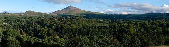
Great Sugar Loaf, from the south
|
|
| Highest point | |
| Elevation | 501 m (1,644 ft) |
| Prominence | 216 m (709 ft) |
| Listing | Marilyn, Arderin |
| Naming | |
| English translation | lump of Cualu |
| Language of name | Irish |
| Geography | |

Great Sugar Loaf
Location in island of Ireland
|
|
| Location | Wicklow, Ireland |
| Parent range | Wicklow Mountains |
| OSI/OSNI grid | O2377613088 |
| Topo map | OSi Discovery 56 |
| Geology | |
| Mountain type | Quartzite bedrock |
| Climbing | |
| Easiest route | Red Lane car-park |
The Great Sugar Loaf (called Ó Cualann in Irish) is a famous mountain in County Wicklow, Ireland. It stands at 501 metres (1,644 ft) tall. Even though it's not the highest mountain in Ireland, it's very well-known.
This mountain is in the northeastern part of the Wicklow Mountains. It looks over the villages of Kilmacanogue and Delgany. Many people think it looks like a volcano, but it's actually not! Its unique shape comes from very old, strong rocks that have resisted erosion over time.
Contents
Why is it Called Sugar Loaf?
The name "Sugar Loaf" might make you think of bread, but it actually refers to how sugar used to be sold. Before we had granulated sugar (the kind you use today), sugar was shaped into tall, cone-like lumps. These lumps looked a bit like a stalagmite, which is a rock formation found in caves.
Hills that have a similar cone shape are often called "Sugar Loaf" in places like Britain and Ireland. This name helps people imagine what the mountain looks like just by hearing its name!
Where is the Great Sugar Loaf?
The Great Sugar Loaf is easy to spot because it stands by itself. It's not surrounded by other tall mountains like some peaks in the Wicklow Mountains. This makes it look even more impressive.
The mountain is circled by roads, making it easy to access. You can see it clearly from the N11 motorway.
Sometimes, people confuse the Great Sugar Loaf with a smaller hill nearby called the Little Sugar Loaf. But the Little Sugar Loaf is actually to the east, across the main N11 road.
What is the Great Sugar Loaf Made Of?
Even though it looks like a volcano, the Great Sugar Loaf is not one. It's made of a very strong rock called quartzite. This rock formed from sandstone at the bottom of ancient oceans during the Cambrian Period. That was a very, very long time ago!
This quartzite rock is super tough and doesn't wear away easily. This is why the Great Sugar Loaf has kept its sharp, distinctive shape while other mountains around it, made of different rocks like granite, have more rounded tops.
The valley below the Great Sugar Loaf, called the Kilmacanogue valley, was carved out by melting ice from glaciers a long time ago.
Hiking the Great Sugar Loaf
The Great Sugar Loaf is a very popular spot for hill walking. It's close to Dublin and easy to get to from the N11 motorway. The paths are well-worn, so you don't need special hiking boots or advanced navigation skills.
One of the best parts about climbing the Great Sugar Loaf is the fun "scrambling" you get to do. This means you'll use your hands a bit to climb over some rocky sections near the top.
The easiest way to climb the mountain is from the south. There's a car park on a road called Red Lane (also known as the L1031 road). This car park is already quite high up, so you only have about 210 metres (690 ft) left to climb to the summit. The walk from here takes about 1 to 1.5 hours round trip. You'll walk on flat paths and then do some fun scrambling to reach the very top.
If you want a longer walk, you can start from the Kilmacanogue GAA car park to the east. This route is about 5 kilometers round trip and takes 2 to 2.5 hours. It also has some gravel and scree sections.
Gallery
-
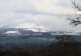
From the west in Winter.
-
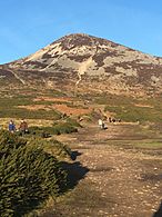
From the Red Lane car-park.
-
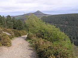
From Maulin.
-
View to Little Sugar Loaf.
-
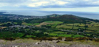
From the Powerscourt Estate

.jpg)


.jpg)
