Maulin facts for kids
Quick facts for kids Maulin |
|
|---|---|
| Málainn | |

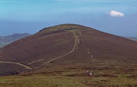
Maulin summit viewed from Tonduff
|
|
| Highest point | |
| Elevation | 570 m (1,870 ft) |
| Prominence | 70 m (230 ft) |
| Listing | Arderin |
| Naming | |
| English translation | High or sloping ground |
| Language of name | Irish |
| Geography | |
| Location | Wicklow, Republic of Ireland |
| Parent range | Wicklow Mountains |
| OSI/OSNI grid | O184131 |
| Topo map | OSi Discovery 56 |
| Geology | |
| Mountain type | Dark blue-grey slate, phyllite & schist |
| Climbing | |
| Easiest route | from Crone Woods |
Maulin (which means "High or sloping ground" in Irish) is a mountain in County Wicklow, Republic of Ireland. It stands at 570 meters (about 1,870 feet) tall. Maulin is part of the beautiful Wicklow Mountains and is located in the northeastern part of the range. At its base, you can find the famous Powerscourt Waterfall.
Exploring Maulin Mountain
Maulin is the 272nd highest peak in Ireland when measured on the Arderin scale. This scale lists mountains that are at least 500 meters (1,640 feet) high. However, because Maulin is just under 600 meters (1,968 feet) tall, it doesn't appear on other lists like the Vandeleur-Lynam or Hewitt scales, which include taller mountains.
Maulin is found in the far northeastern part of the Wicklow Mountains. It sits right at the entrance to the Glensoulan Valley. This area is known for its stunning natural beauty and is a popular spot for hikers.
Getting to Maulin
You can easily reach Maulin by following the trails that go through Crone Woods. This area is home to a large forest of Sitka spruce trees. These tall, green trees make the walk very scenic.
Maulin is also close to the main Wicklow Way, which is a long-distance walking trail. This makes it simple for people exploring the Wicklow Mountains to visit Maulin.
The Glensoulan Circuit
Many people enjoy climbing Maulin as part of a longer walking route. This route is called the Circuit of Glensoulan. It's a loop that starts and ends at the car park in Crone Woods.
The full circuit is about 16 kilometers (10 miles) long. It takes you around Maulin and then to other nearby mountains. These include Tonduff (642 meters or 2,106 feet), War Hill (686 meters or 2,251 feet), and Djouce (725 meters or 2,379 feet). After exploring these peaks, the trail leads you back to the Crone Woods car park.
Nearby Places
At the base of Maulin, in an area called Lackandarragh, you'll find the Knockree An Óige youth hostel. This is a great place for young people and families to stay if they want to explore the mountains. It's located near the small village of Enniskerry.
 | John T. Biggers |
 | Thomas Blackshear |
 | Mark Bradford |
 | Beverly Buchanan |


