War Hill facts for kids
Quick facts for kids War Hill |
|
|---|---|
| Cnoc an Bhairr | |

|
|
| Highest point | |
| Elevation | 686 m (2,251 ft) |
| Prominence | 71 m (233 ft) |
| Listing | Hewitt, Arderin, Simm, Vandeleur-Lynam |
| Naming | |
| English translation | Hill of the summit |
| Language of name | Irish |
| Geography | |
| Location | Wicklow, Republic of Ireland |
| Parent range | Wicklow Mountains |
| OSI/OSNI grid | O1689511338 |
| Topo map | OSi Discovery 56 |
| Geology | |
| Mountain type | Granite with microcline phenocrysts Bedrock |
| Climbing | |
| Easiest route | via Djouce Mountain |
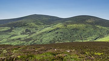
War Hill is a mountain in Ireland, standing at 686 meters (about 2,251 feet) tall. It's one of the highest peaks in the country. This mountain is located in the far northeastern part of the Wicklow Mountains in County Wicklow.
Because War Hill is a bit out of the way, people usually visit it as part of a longer hike. They often combine it with climbs up nearby mountains like Djouce or Maulin. A unique landmark in the area is the Coffin Stone, a mysterious group of rocks found between War Hill and Djouce.
Contents
What's in a Name? The Story of War Hill
The name "War Hill" is quite interesting! Some people thought its Irish name might be Cnoc an Bhairr, meaning "Hill of the summit." However, experts like Paul Tempan say there's no old Irish record to prove this.
Also, the word "Barr" (summit) usually comes first in Irish mountain names. But War Hill isn't the highest peak around; its neighbor, Djouce, is taller at 725 meters (about 2,379 feet).
So, it's possible that "War Hill" has always been an English name. An old letter from 1838 by an Irish historian named Eugene O’Curry mentions a place called "the Churchyard" near War Hill. People believed it was where those who died in a battle between English troops and the O’Tooles (an Irish family) were buried about 300 years before that letter was written. This battle was said to have happened right on War Hill!
Where is War Hill? Geography Facts
War Hill sits on the northern side of its taller neighbor, Djouce mountain. From War Hill, you can look down into the beautiful Glensoulan Valley. The River Dargle flows through this valley and eventually reaches Powerscourt Waterfall, which is the highest waterfall in Ireland!
To the north, across the River Dargle valley, you can see other mountains like Tonduff and Maulin. An Irish hiking writer, J.B. Malone, once described the area around War Hill as a "bog desert," meaning it's a very wet and marshy place.
Hiking Adventures on War Hill
Since War Hill is in a remote spot, most hikers climb it as part of a longer journey that includes other nearby mountains.
One popular hiking route is about 15 kilometers (about 9 miles) long. It starts at the Ballinastoe Wood car park. From there, you follow a special boarded path (like a wooden walkway) up to White Hill and then towards Djouce mountain. Instead of going all the way to the top of Djouce, hikers follow the path east to cliffs above the Powerscourt Waterfalls. The loop then goes back up to War Hill, crosses to the summit of Djouce, and finally returns to Ballinastoe Wood.
Another exciting way to explore the area is a 16-kilometer (about 10 miles) loop called the Circuit of Glensoulan. This route starts at the Crone Woods car park and takes you to the tops of Maulin (570 meters), Tonduff (642 meters), War Hill, and Djouce, before heading back to Crone Woods.
The Mysterious Coffin Stone
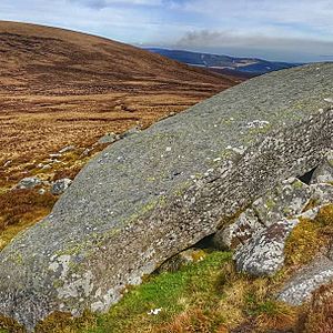
Between War Hill and Djouce, you'll find a group of large rocks known as the Coffin Stone. These stones are located at O178104. The Irish Mountaineering Club notes that, according to J.B. Malone, these were the only natural rock features shown on an old map of the Dublin and Wicklow mountains.
The largest of these rocks is a huge, collapsed boulder, about 5 meters (16 feet) long. People have wondered if it's an ancient Irish megalithic portal tomb (a very old burial site made of large stones) or perhaps a glacial erratic. A glacial erratic is a large rock that was carried a long distance by a glacier during the Ice Age and then left behind when the ice melted. It's a fun mystery to think about when you're hiking there!
 | Laphonza Butler |
 | Daisy Bates |
 | Elizabeth Piper Ensley |


