
Djouce facts for kids
Quick facts for kids Djouce |
|
|---|---|
.jpg)
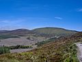
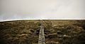
Djouce (l) and White Hill (r).
Note Djouce's boardwalk path on White Hill |
|
| Highest point | |
| Elevation | 725 m (2,379 ft) |
| Prominence | 200 m (660 ft) |
| Listing | 100 Highest Irish Mountains, Marilyn, Hewitt, Arderin, Simm, Vandeleur-Lynam |
| Naming | |
| Native name | Error {{native name}}: an IETF language tag as parameter {{{1}}} is required (help) |
| English translation | 'Fortified height' |
| Pronunciation | English: /ˈdʒaʊs/ jowss Irish: [ˈdʲəuʃ] |
| Geography | |

Djouce
Location in island of Ireland
|
|
| Location | Wicklow, Republic of Ireland |
| Parent range | Wicklow Mountains |
| OSI/OSNI grid | O1785810360 |
| Topo map | OSi Discovery 56 |
| Geology | |
| Mountain type | Dark blue-grey slate, phyllite & schist Bedrock |
| Climbing | |
| Easiest route | Wicklow Way, from the south (via White Hill / J.B. Malone memorial), or east (via Maulin), on the boarded mountain path |
Djouce (pronounced 'JOWSS') is a mountain in County Wicklow, Ireland. It stands 725 meters (2,379 feet) tall. This makes it one of the highest peaks in the country. Djouce is part of the beautiful Wicklow Mountains range. From its slopes, you can see amazing views of the surrounding area.
What makes Djouce special is its unique 'boardwalk' path. This path, made from old railway sleepers, helps people climb the mountain easily. It also protects the delicate bog and soil underneath from being worn away. Djouce is very popular with hikers. It lies along the 131-kilometer Wicklow Way, a famous long-distance walking trail. On its southern side, there's a special stone called the J.B. Malone memorial stone. This stone honors the person who created the Wicklow Way.
Contents
What's in a Name?
The name Djouce comes from the Irish word Dioghais, which means 'fortified height'. This suggests it might have been a strong, high place in the past. Sometimes, in old writings, it was called 'Dowse'. The official map from the Ordnance Survey Ireland (OSI) calls it Djouce Mountain.
Mountain Geography
Djouce is home to the start of the River Dargle. This river begins on the mountain's northern side. Close by, the River Liffey also starts, but it flows in a different direction.
One of Ireland's tallest waterfalls, Powerscourt Waterfall, is found on the eastern side of Djouce. The mountain also looks over Lough Tay, a beautiful lake shaped like a corrie (a bowl-shaped valley). Djouce is surrounded by several roads, making it easy to reach.
The lower slopes of Djouce are covered in thick forests. These forests mainly have Sitka spruce trees. However, when these trees are cut down, new native trees are being planted. This helps bring back the natural Irish woodlands.
Djouce has a nearby shoulder called White Hill, which is 630 meters (2,067 feet) high. To the north, across a small dip, is War Hill, standing 686 meters (2,251 feet) tall.
Hiking Djouce Mountain

Djouce is a favorite spot for people who love to hike. This is because it's easy to get to and offers fantastic views.
The main way to reach the top of Djouce is by using the Boardwalk path. The Office of Public Works (OPW) built this path between 1997 and 1999. They used old railway sleepers to create it. The path has been improved over time to protect the ground and bog from hikers' footsteps.
You can start your hike from the Ballinastoe Wood car park. There's also the J.B. Malone car park nearby. The first stop on the path is the J.B. Malone memorial stone. From here, you get amazing views of Lough Tay and Luggala mountain.
The boarded path then goes up to White Hill. After that, it turns north towards the summit of Djouce. Near the top, the boardwalk turns east along the Wicklow Way. To reach the very top of Djouce, you leave the boardwalk and follow a stone path. The walk from the car park to the summit and back is about 7 kilometers (4.3 miles). You don't need special hiking shoes for this route, and it's easy to follow because of the clear paths.

Some hikers like to make a "loop route" when coming down. Instead of going back the same way, they walk across the bogland to find forest paths in Ballinastoe Wood. These paths lead back to the car parks. Other longer routes include climbing War Hill (686 meters or 2,251 feet) to the north of Djouce, making a 15-kilometer (9.3 miles) loop.
Boardwalk Safety

In 2016, there was a court case about the safety of mountain boardwalks in Ireland. A hiker named Teresa Wall had an accident on the Djouce boardwalk. She tripped and hurt her knee near the J.B. Malone memorial stone. She sued the National Parks and Wildlife Service (NPWS).
At first, a court ruled in her favor. However, in 2017, the NPWS won an appeal in a higher court. The High Court decided that the rules for safety on mountain trails are different from those in other places. This case was important for how mountain paths are managed in Ireland.
1946 Plane Crash
On August 12, 1946, a plane carrying 21 girl guides crashed on Djouce mountain. The plane was a Junkers Ju 52/3m. The girls were on a trip to meet Irish girl guides. The weather was very bad when the plane crashed into the upper slopes of Djouce.
Luckily, the plane's engines ripped off, so the main part of the plane did not catch fire. All 27 people on board survived the crash. Some had serious injuries, but everyone lived.
Images for kids
-
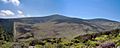
Western slopes
-
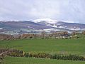
Djouce from southeast
-
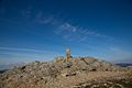
Trig. point on summit
-
Northern slopes
-
Boardwalk on White Hill


