
Wicklow Way facts for kids
Quick facts for kids The Wicklow Way(Slí Cualann Nua) |
|
|---|---|

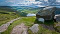
The J. B. Malone memorial at Barr Rock on the Wicklow Way overlooking Lough Tay.
|
|
| Length | 128 kilometres (80 miles) |
| Location | Eastern Ireland |
| Designation | National Waymarked Trail |
| Trailheads | Marlay Park, County Dublin Clonegal, County Carlow |
| Use | Hiking |
| Elevation gain/loss | 3,320 m (10,892 ft) |
| Highest point | White Hill (630 m (2,067 ft)) |
| Lowest point | Clonegal (60 m (197 ft)) |
| Difficulty | Strenuous |
| Season | Any |
| Sights | Wicklow Mountains Glendalough |
| Surface | Forestry tracks, roads, boreens and mountain paths |
| Website | www.irishtrails.ie |
| Map overview | |
 |
|
The Wicklow Way (which in Irish is Slí Cualann Nua, meaning "New Cuala Way") is a long walking path. It stretches for about 131 kilometers (81 miles). This trail crosses the beautiful Wicklow Mountains in Ireland.
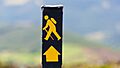
The path starts in Marlay Park in the southern part of Dublin. It then goes through County Wicklow and finishes in the village of Clonegal in County Carlow. It's known as a National Waymarked Trail. This means it has special yellow "walking man" symbols and arrows to guide you. Most people take 5 to 7 days to walk the whole trail. It's one of Ireland's most popular walking paths. About 24,000 people walk parts of it each year!
The Wicklow Way follows different types of paths. You'll walk on forest tracks, mountain paths, small country roads called boreens, and quiet country lanes. The northern parts of the trail have mountains, lakes, and deep valleys carved by glaciers. As you go south, the hills become gentler. The path often follows where two types of rock meet: hard granite on the west and softer schist and slate on the east.
Along the way, you'll see many different natural areas. In the mountains, there are forests, open areas called heath, and wet, spongy land called blanket bog. In the lower areas, hedges between fields are home to lots of wildlife. The trail also passes the ancient Monastic City at Glendalough. This special place was started in the 6th century by Saint Kevin.
Contents
A Journey Through Time: The Wicklow Way's Story
The idea for the Wicklow Way came from a man named J. B. Malone. He wrote about it in newspapers in 1966. In 1977, Malone helped create a committee to make his idea real. He first wanted a circular path around Wicklow. But the government wanted a straight path to be part of a bigger network of trails across Ireland.
The first part of the trail opened in 1980. The whole path was finished in 1982. It was the first of many National Waymarked Trails in Ireland. Now, there are over forty such trails, covering more than 4,000 kilometers (2,500 miles)! The Wicklow Way is also part of a huge European walking route called E8. This route goes all the way from the Atlantic coast of County Cork to Istanbul in Turkey. A special memorial to J. B. Malone was put up near Lough Tay to remember his important work.


The path has changed a few times since it opened. This usually happens because of erosion (when the ground wears away) or issues with land access. For example, parts of the path were moved away from Fairy Castle and Mullacor mountain to protect the land. In 1999, the path was moved away from Laragh village. This was due to a local landowner's request. In 2006, new signs and stone markers were added to celebrate the trail's 25th birthday. Today, the Wicklow Way is looked after by the Wicklow Outdoor Recreation Committee.
Exploring the Wicklow Way: North to South
The Wicklow Way has special markers in both directions. You can start at Marlay Park or Clonegal. The trail markers are black posts with a yellow walking man symbol and an arrow. These symbols are used on all National Waymarked Trails in Ireland. Brown signs are used where the path follows roads. Most people walk the whole trail in five to seven days.
Marlay Park to Knockree: Starting Your Adventure

If you start in the north, the Wicklow Way begins in Marlay Park. This park is on the edge of Dublin. It was designed in the late 1700s. You'll see a map board at the start. You step through a stone gate to begin your walk. The path goes through the park, following a wooded area along the Little Dargle River.
After leaving the park, you'll go under the M50 motorway. Then you climb Kilmashogue Lane and enter a forest on Kilmashogue mountain. This is one of many forests you'll walk through. These forests have trees like Sitka spruce, Scots pine, and beech. The ground here is mostly granite rock. The trail goes around the mountain and then opens up onto moorland near Fairy Castle. This area has heather, purple moor grass, and bog cotton. You might see birds like red grouse and skylarks.
The path crosses a low point between Two Rock and Tibradden Mountain. It then goes down into the Glencullen valley. Here, it follows the R116 road to Boranaraltry. The road has farms with hedges on both sides. Climbing from Boranaraltry, the trail goes over the shoulder of Prince William's Seat. This is where you leave County Dublin and enter County Wicklow! The land here changes between wet bog and open heath. The trail then goes down into the Glencree valley. It passes through Curtlestown Wood and Lackan Wood. Finally, it crosses the shoulder of Knockree Hill.
Knockree to Oldbridge: Valleys and Views

From Knockree, much of the path follows where granite rock meets schist and slate. The trail follows the Glencree River through Seskin Wood. This wood has oak and hazel trees. It's a good place to see jays. After crossing a footbridge, the trail goes into Crone Woods. It climbs to Ride Rock. From here, you can see Powerscourt Deerpark and the amazing Powerscourt Waterfall. It's the tallest waterfall in Ireland!
You might see deer in the forests and mountains here. They are a mix of Japanese Sika and native Red deer. They all came from the Powerscourt herd. The next valley is Glensoulan. Long ago, people lived here, and you can still see faint signs of their old farms in winter.
Crossing the River Dargle, the trail climbs the side of Djouce mountain. Here, the land becomes wet blanket bog. This bogland has plants like bog cotton and bog asphodel. It's also home to frogs and diving beetles. Near the top of Djouce, the Way joins a wooden path called a tóchar or bog bridge. This bridge protects the bog from erosion. It crosses White Hill, the highest point on the Way at 630 meters (2,067 feet).
The trail goes down White Hill towards Luggala. You'll walk along a ridge called the Barr. Here, you'll find a memorial stone for J. B. Malone. It overlooks Lough Tay. From Luggala, the trail goes through a forest of spruce and pine trees. It reaches Oldbridge, where it crosses the River Avonmore near Lough Dan.
Oldbridge to Glendalough: Ancient History and Nature

Leaving Oldbridge, the Way follows a road for about 4 kilometers (2.5 miles). Then it turns onto a boreen. To your left is Wart Stone Field. It's named after a special stone. People say water from this stone can cure warts! The boreen ends at Brusher Gap. People say locals used to leave food here for Michael Dwyer and his friends. They were hiding after the 1798 Rebellion.
The Way enters Drummin forest, a spruce tree farm. Here, you'll see an Adirondack shelter. This shelter was built by Mountain Meitheal, a group of volunteers who help keep the trails nice. The trail climbs Paddock Hill. Then it goes down into a forest of larch trees. The forest floor here has spurges and fly agaric mushrooms.
The trail crosses the Military Road near Laragh. Then it crosses a wooden bridge over the Glenmacnass River. The riverbed is full of granite boulders. These were left behind by melting glaciers long ago. This part of the trail follows an old mass path. It goes through a forest with native Irish trees like oak, rowan, and silver birch. The ground is covered with bilberry, bluebells, and hard fern.
The Way continues along forest tracks over Brockagh Mountain. At the highest point, you get an amazing view of the Vale of Glendalough. You can see the two lakes nestled between Camaderry and Derrybawn Mountains. Leaving the forest, the Way reaches the R756 road and the Glendalough visitor center. After crossing the Glendasan River, you'll pass the old Monastic City. This city was founded in the 6th century by Saint Kevin.
Glendalough to Iron Bridge: Into the Longest Valley

Most of this part of the trail is on forest roads. From the Monastic City at Glendalough, the Way follows the Green Road towards the Upper Lake. It goes through a native woodland with oak, holly, birch, and rowan trees. Climbing from the Upper Lake, the trail reaches Poulanass Waterfall. This waterfall has carved a narrow gorge through the rock over thousands of years.
The trail continues climbing through the forest. It then comes out onto a saddle (a low point between two peaks) between Mullacor and Lugduff mountains at Borenacrow. This route between Glendalough and Glenmalure is very old. People say Saint Kevin used this path to go to Mass in Glenmalure. Ahead, you'll see the Glenmalure valley. It's the longest glacial valley in Ireland and Great Britain! You can also see Lugnaquilla, Wicklow's highest mountain.
The Way then starts a long descent into Glenmalure. Along the way, you'll pass another Adirondack shelter. It was built by the Mountain Meitheal volunteers. When you reach the valley floor, the Way joins the Military Road. It leads to Drumgoff Crossroads. Crossing the River Avonbeg, you'll pass the remains of an old military barracks built around 1800. Then you enter Drumgoff Wood. At the forest entrance, there's a granite pillar. It marks the official halfway point of the Wicklow Way!
The trail follows a forest road along the side of Slieve Maan. It briefly joins the Military Road again. Then it follows a forest road around Carrickashane Mountain. Finally, it reaches the road at Iron Bridge, where the Way crosses the Ow River. Another Adirondack shelter can be found at Mucklagh.
Iron Bridge to Derry River: Gentle Hills and Farmland

After Iron Bridge, the Wicklow Way changes. The steep hills become gentler, and the path winds through low hills. These southern parts also have more walking on roads. The Way crosses farmland using small roads and boreens.
Hedges of hawthorn and blackthorn separate the fields. They are home to many wild flowers, insects, and birds. You might see dog roses, purple foxgloves, and wild violets. Birds like wrens, blackbirds, and song thrushes live here too.
The Way climbs through a gap between Ballygobban and Shielstown Hills. From here, you can see far and wide. You might see Lugnaquilla and Keadeen Mountain. The hills ahead mark the end of the granite mountains. In the distance, they blend with the Blackstairs Mountains. The trail follows the road near Moyne village. Then it joins a boreen. Along this boreen are the remains of a holy well dedicated to Saint Colmcille.
The trail goes around Ballycumber Hill. Then it continues along the eastern slopes of Garryhoe Hill. You'll pass the remains of an old ringfort, about 15 meters (49 feet) wide. Further along is a memorial to Dr James McNamara, who died in a shooting accident in 1916. The trail follows Coolafunshoge Lane. This old path was used for droving animals. It offers great views of south Wicklow. The lane comes out onto the road, crossing a bridge over the River Derry. It reaches the R747 road near Tinahely.
Derry River to Clonegal: The Final Stretch

The trail follows an ancient path for driving cattle around Muskeagh Hill. Then it joins a series of country roads. About 63% of this last part is on roads. These roads pass through Mullinacuff village. Its church and cottages are built from local granite.
At Stranakelly Crossroads, you'll pass Tallon's pub. It's better known as the "Dying Cow." The story goes that when police visited late one night, the landlady said she wasn't serving drinks after hours. She was just giving refreshments to neighbors who were helping her with a dying cow!
The path circles Cronlea Hill, which has a windfarm on top. It passes near Kilquiggan village. The Way crosses the R725 road near Shillelagh. The trail enters a forest at Raheenakit. Then it joins an old drovers' road. This road was once used to herd sheep to market in Shillelagh. The Blackstairs Mountains start to appear on the horizon. You can see Mount Leinster with its television mast.
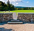
The trail winds along forest tracks around Moylisha and Urelands Hills. Urelands Hill has lots of hornblende-rich schist rock. This rock is from ancient volcanic islands that existed 450–500 million years ago! Back then, this part of Ireland was under a huge ocean. Joining the road for the last part into Clonegal, the Way leaves County Wicklow and enters County Carlow at Wicklow Bridge. This is about 3 kilometers (1.9 miles) from the end. The Wicklow Way finishes in the village green of Clonegal. Here, you'll find a stone bench and a map board showing the whole route.
Connecting Paths and Fun Events

The Wicklow Way is part of the E8 European walking route. This route goes from Dursey Island in County Cork to Istanbul in Turkey. The Irish part of E8 includes the Wicklow Way and other trails like the South Leinster Way. There's also an unmarked path from Dublin Port to the Wicklow Way start at Marlay Park. This path follows the River Dodder.
The Wicklow Way also shares part of its route with the Dublin Mountains Way. This is along a ridge between Two Rock and Tibradden. The Saint Kevin's Way Pilgrim Path starts at Hollywood or Valleymount. It ends at Glendalough, where it connects with the Wicklow Way.
Some parts of the Wicklow Way are also used by National Looped Walks. These are shorter circular paths.
Sporting Challenges on the Way

Many mountain running events happen along the Wicklow Way. The Wicklow Way Relay is a race for teams of 2 to 8 runners. It goes between Kilmashogue and Shillelagh. The Wicklow Way Ultra (also called Maurice Mullins Ultra) is a 51-kilometer (32-mile) race for individuals. It runs between Glencullen and Ballinastoe Woods. The fastest time for running the entire Wicklow Way from Marlay Park to Clonegal is 12 hours, 11 minutes, and 7 seconds. This record was set by Robbie Britton in 2019. The ladies' record was set by Aoife Mundow in 16 hours, 6 minutes, and 30 seconds.
Getting There: Public Transport
You can get to the start of the Wicklow Way at Marlay Park using Dublin Bus routes. There is no public transport directly to or from the end of the trail in Clonegal. However, nearby villages like Kildavin and Bunclody, County Carlow, have bus routes. Some places along the route also have bus services. The St. Kevins Bus Service stops at Roundwood, Laragh, and Glendalough. The Wicklow Way Bus provides services to Laragh, Glendalough, Glenmalure, Iron Bridge, and Tinahely.
Images for kids
-
The J. B. Malone memorial at Barr Rock on the Wicklow Way overlooking Lough Tay.
-
Marlay Park
-
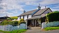
Clonegal
-
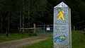
"Walking man" waymarker on the Wicklow Way
-
Powerscourt Deerpark and Waterfall with Djouce mountain in the distance as seen from Ride Rock along the Wicklow Way
-
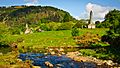
The Wicklow Way passes the ancient Monastic City at Glendalough
-
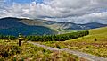
Lugnaquilla, Wicklow's highest mountain, seen as the Wicklow Way descends into Glenmalure
-
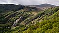
The character of the Wicklow Way changes from high mountains to low rolling hills in the southern sections
-
The "Dying Cow" pub at Stranakelly Crossroads
-
The halfway point of the Wicklow Way at the entrance to Drumgoff Forest, Glenmalure
-
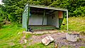
Mullacor Hut, an Adirondack shelter constructed by volunteer group Mountain Meitheal on the Wicklow Way in Glenmalure

