
Glenmalure facts for kids
Quick facts for kids Glenmalure |
|
|---|---|
| Gleann Molúra | |

Glenmalure Valley
|
|

Glenmalure
Location in island of Ireland
|
|
| Length | 20 km (12 mi) NW-SE |
| Width | 0.8 km (0.50 mi) |
| Area | 405 Ma |
| Depth | 0.35 km (0.22 mi) |
| Geology | |
| Type | U-shaped glacial valley |
| Geography | |
| Location | Wicklow Mountains, Ireland |
| Borders on | Glendalough and Lugnaquilla |
| Topo map | OSi Discovery 56 |
| Traversed by | The Glen Road |
| Rivers | River Avonbeg |
Glenmalure (Irish: Gleann Molúra) is a 20-kilometre long U-shaped glacial valley located in the Wicklow Mountains in Ireland. It's a popular spot for hiking and climbing, especially to reach Lugnaquilla mountain. You'll also find one of Ireland's oldest An Oige youth hostels here. Glenmalure also has a rich history, known for the Battle of Glenmalure in 1580 and events during the Irish Rebellion of 1798.
Contents
Exploring Glenmalure's Landscape
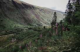
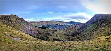
Glenmalure is a long, U-shaped valley in the southern part of the Wicklow Mountains. It's one of the longest glacial valleys in Ireland, stretching for 20 kilometers.
How Glaciers Shaped the Valley
Many smaller valleys, called hanging valleys, join Glenmalure. A good example is the Fraughan Rock Glen. These were formed by smaller glaciers during the last Ice Age. These smaller glaciers fed into the main glacier that carved out Glenmalure.
Mountains Around Glenmalure
The valley runs from the northwest to the southeast. On its western side is the large mountain massif of Lugnaquilla, which is 925 meters (3,035 feet) high. Lugnaquilla is the highest point in Wicklow county and in the province of Leinster.
The eastern side of the valley has steep slopes from Lugduff (652 meters / 2,139 feet) and Mullacor (657 meters / 2,156 feet). These mountains also border the nearby Glendalough valley.
The Valley's Head and Trails
The very top, or "head," of Glenmalure valley is surrounded by a boggy, horseshoe-shaped area. This area includes Camenabologue (758 meters / 2,487 feet), Table Mountain (702 meters / 2,303 feet), and Conavalla (734 meters / 2,408 feet).
Old trails called Table Tracks connect Glenmalure valley to the Art O'Neill's cross area. These trails cross the "central spine" of the entire Wicklow Mountains range.
Understanding Glenmalure's Rocks
The rocks under Glenmalure valley were formed a very long time ago, about 405 million years ago. They are mostly made of a type of rock called Leinster Granite. This granite is part of a larger rock formation called the "Lugnaquillia Pluton." There are different kinds of granite found throughout the valley.
The rocks around the granite are older and were changed by heat and pressure. The granite also has veins of quartz, which contain lead and zinc. The valley itself, and its features like the U-shape, were created during the last Ice Age.
Glacial Features in the Valley
At the bottom of the valley, you can see piles of rock and dirt called moraines. These were left behind by the glaciers as they moved. There are moraines that cross the valley and also along its southwestern side.
Fun Activities in Glenmalure
Glenmalure is a fantastic place for hill walking and mountain climbing.
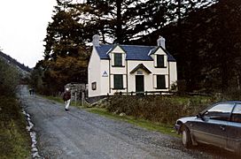
The Glenmalure Youth Hostel
The An Oige Glenmalure Youth Hostel is a special place to stay. It's located where the Fraughan Rock Glen meets the main valley. This hostel is open during the summer months. It's quite rustic, meaning it doesn't have running water or electricity, which makes it a unique experience!
The building dates back to 1903, when it was a hunting lodge. Many famous people have stayed there, including Countess Markievicz, Maud Gonne, her son Sean McBride, Eamon De Valera, and W. B. Yeats.
Hiking the Glenmalure Loop
One popular hike is the 15-kilometer (9-mile) Glenmalure Loop. It takes about 5 to 6 hours and is known as "the most scenic circuit to Lugnaquilla."
The hike starts at the Baravore car-park at the head of the valley. You climb up to Lugnaquilla mountain by going through the hanging valley called Fraughan Rock Glen. You enter this glen near the Glenmalure hostel.
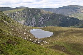
On the way back, you pass over Cloghernagh (800 meters / 2,625 feet) and then descend to the beautiful Arts Lough (511 meters / 1,677 feet). This lake is described as "one of the region's most beautiful sights." From there, you head back down to where the Fraughan Rock Glen begins.
Glenmalure's Past
Glenmalure was once a stronghold for the Gabhail Raghnal branch of the O'Byrne clan at Balinacor.
The Battle of Glenmalure (1580)
In 1580, Glenmalure was the site of the Battle of Glenmalure. An English army tried to capture Balinacor, which was the home of a rebel leader named Fiach MacHugh O'Byrne. However, the English force was defeated badly. It was one of the worst defeats for an English army in Ireland, with many soldiers lost.
A large rock near the Military Road crossroads has carvings on it. One side remembers Fiach MacHugh, and the other side remembers Michael Dwyer, another important historical figure.
Glenmalure Barracks
South of this crossroads, on the road to Rathdangan and Aughrim, you can find the ruins of Glenmalure Barracks. The British army built this barracks to try and catch rebels after the 1798 rebellion.
Gallery
-
Disused crusher house
-
An Oige youth hostel
-
From Fraughan Rock Glen across to summit of Lugduff
-
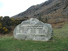
Glenmalure 1798 memorial
-
Arts Lough with Conavalla back right


