
Lugduff facts for kids
Quick facts for kids Lugduff |
|
|---|---|
| Log Dubh | |

Summit of Lugduff from across the Glenmalure valley on Camenabologue.
|
|
| Highest point | |
| Elevation | 652 m (2,139 ft) |
| Prominence | 97 m (318 ft) |
| Listing | Hewitt, Arderin, Simm, Vandeleur-Lynam |
| Naming | |
| English translation | black hollow |
| Language of name | Irish |
| Geography | |

Lugduff
Location in island of Ireland
|
|
| Location | Wicklow, Ireland |
| Parent range | Wicklow Mountains |
| OSI/OSNI grid | T0722095361 |
| Topo map | OSi Discovery 56 |
| Geology | |
| Mountain type | Dark blue-grey slate, phyllite & schist |
Lugduff (which means "black hollow" in Irish) is a mountain in Ireland. It stands tall at 652 meters (about 2,139 feet). Lugduff is one of the highest peaks in Ireland. It is ranked 154th on one list of mountains (the Arderin scale) and 186th on another (the Vandeleur-Lynam scale).
About Lugduff
Lugduff is located in the southern part of the beautiful Wicklow Mountains range. It forms a wide, curved shape around the Upper Lake of the Glendalough valley. Nearby mountains include Mullacor (661 meters), Conavalla (734 meters), Turlough Hill (681 meters), and Camaderry (699 meters).
Mountain Features
The western sides of Lugduff are very steep. They have a unique "wavy" look, like corrugated iron. These slopes form the deep eastern wall of the Glenmalure valley. The western walls of Lugduff also meet where the Fraughan Rock Glen valley joins the Glenmalure valley. Fraughan Rock Glen is a "hanging valley." This means its floor is higher than the main valley it joins.
Popular Trails
Just below the top of Lugduff, you'll find a popular walking path called The Spinc. This path is 8 kilometers long and is made of wooden boards. It offers amazing views around the Upper Lake of Glendalough. To the south of Lugduff, there is a smaller peak called Lugduff SE Top, which is 637 meters high.
Images for kids
-
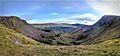
Summit of Lugduff and its western slopes, from the Fraughan Rock Glen
-
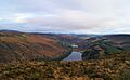
View from summit into Glendalough, Upper (near) and Lower (far) lakes
-
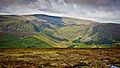
View from summit across Glenmalure into Fraughan Rock Glen, and Lugnaquilla


