
Wicklow facts for kids
Quick facts for kids
Wicklow
Cill Mhantáin
|
||
|---|---|---|
|
Town
|
||

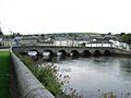
Parnell Bridge over the River Vartry in Wicklow
|
||
|
||
| Motto(s):
Mo radharc tar sál sínim
|
||

Wicklow
Location in Ireland
|
||
| Country | Ireland | |
| Province | Leinster | |
| County | County Wicklow | |
| Elevation | 69 m (226 ft) | |
| Population | ||
| • Total | 12,957 | |
| Time zone | UTC±0 (WET) | |
| • Summer (DST) | UTC+1 (IST) | |
| Eircode routing key |
A67
|
|
| Telephone area code | +353(0)404 | |
| Irish Grid Reference | T312940 | |

Wicklow (/ˈwɪkloʊ/ WIK-loh) is a town in County Wicklow, Ireland. Its Irish name, Cill Mhantáin, means 'church of the toothless one'. It is located on the east coast of Ireland, south of Dublin.
In 2022, about 12,957 people lived there. Wicklow is east of the M11 route that connects Dublin and Wexford. It also has train lines to Dublin, Wexford, Arklow, and Rosslare Europort. Wicklow has a port where timber and textiles are imported. The River Vartry flows through the town.
Contents
Exploring Wicklow's Landscape
.jpg)
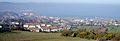
Wicklow town is shaped like a half-circle around Wicklow harbour. To the north, you'll find 'The Murrough', a large grassy area by the sea. It's a popular spot for walks. This area is also becoming more used for businesses. A new road was built in 2010 to help traffic bypass the town and go straight to the business area.
The eastern coast includes Wicklow Bay, which is a long, curved stone beach. It stretches for about 10 kilometers.
Hills and Headlands
Ballyguile Hill is to the southwest of Wicklow town. Many houses were built here in the 1970s and 1980s, even though it's quite a steep climb from the town centre.
To the west, the land rises into gentle hills that eventually meet the Wicklow Mountains. To the south, you can see the rocky areas of Bride's Head and Wicklow Head. Wicklow Head is the easternmost point of mainland Ireland. On a very clear day, you might even see the Snowdonia mountains in Wales across the sea!
Wicklow's Weather
Wicklow has a maritime climate, which means it has cool summers and mild winters. Temperatures don't usually get too extreme. In January, the average high temperature is about 9.2°C (48.6°F). In August, the average high is around 21.2°C (70.2°F). May is usually the sunniest month.
October is the wettest month, with about 118.9 mm (4.6 inches) of rain. April is the driest, with 60.7 mm (2.4 inches). Rain is spread out fairly evenly through the year, except for October and November, which get almost twice as much rain as April.
Wicklow is protected by Ballyguile hill and the Wicklow Mountains. This makes it one of the driest and warmest places in Ireland. It gets about 60% less rain than the west coast. Because the mountains block winds from the southwest and west, Wicklow also has higher average temperatures than much of Ireland. Its average high in August is 1°C higher than Dublin, which is only 50 km north.
However, Wicklow is open to easterly winds. These winds come from northern Europe, so the east coast of Ireland, including Wicklow, can have short periods of very cold weather in winter.
| Climate data for Ashford, County Wicklow, (5 km north of Wicklow) | |||||||||||||
|---|---|---|---|---|---|---|---|---|---|---|---|---|---|
| Month | Jan | Feb | Mar | Apr | May | Jun | Jul | Aug | Sep | Oct | Nov | Dec | Year |
| Mean daily maximum °C (°F) | 9.2 (48.6) |
9.6 (49.3) |
11.2 (52.2) |
12.9 (55.2) |
15.6 (60.1) |
18.2 (64.8) |
19.5 (67.1) |
21.2 (70.2) |
18.1 (64.6) |
14.8 (58.6) |
11.7 (53.1) |
9.2 (48.6) |
14.2 (57.6) |
| Mean daily minimum °C (°F) | 2.9 (37.2) |
2.8 (37.0) |
3.4 (38.1) |
4.7 (40.5) |
6.9 (44.4) |
9.4 (48.9) |
11.2 (52.2) |
11.3 (52.3) |
10 (50) |
7.4 (45.3) |
4.8 (40.6) |
3.1 (37.6) |
6.5 (43.7) |
| Average rainfall mm (inches) | 86 (3.4) |
61.8 (2.43) |
63.6 (2.50) |
60.7 (2.39) |
65.8 (2.59) |
72.1 (2.84) |
67 (2.6) |
69.8 (2.75) |
72.1 (2.84) |
118.9 (4.68) |
110.9 (4.37) |
85.6 (3.37) |
935 (36.8) |
| Average precipitation days (≥ 1 mm) | 14 | 10 | 9 | 10 | 10 | 10 | 10 | 10 | 9 | 13 | 13 | 11 | 129 |
| Mean monthly sunshine hours | 68.0 | 83.2 | 136.8 | 180.4 | 204.0 | 189.4 | 163.2 | 158.5 | 135.9 | 103.3 | 83.8 | 65.9 | 1,572.4 |
| Source 1: Met Éireann | |||||||||||||
| Source 2: Ashford Weather Station, | |||||||||||||
Wicklow's Economy
Since 1995, Wicklow has grown a lot, just like the rest of the Irish economy. Many new homes have been built, especially to the west and northwest of the town.
In 2004, a new bypass road was finished. This road connects Wicklow to Dublin (about 42 km north) with a dual carriageway and motorway. Because of this, more people are moving to Wicklow and traveling to Dublin for work. This has made Wicklow an important commuter town.
The Story Behind Wicklow's Name
The name Wicklow has been spelled in different ways over time, like Wykinglo in 1173. Most people think the name comes from Old Norse words. Vikingr means "Viking" and ló means "meadow". So, Wicklow could mean "the Vikings' meadow".
However, some experts disagree. They point out that -lo was mostly used in Norway. Also, the word "Viking" doesn't usually appear in place names. They suggest the first part of the name might come from an Old Norse word meaning "bay".
The Irish name for the town, Cill Mhantáin, has a different story. It means "church of the toothless one". This name comes from an old legend about Saint Patrick. It's said that when Saint Patrick and his followers tried to land on Travailahawk beach, locals attacked them. One of Patrick's group lost his front teeth. He became known as Manntach, meaning "toothless one". He later returned to the town and started a church there. That's how the name Cill Mhantáin came about.
A Look at Wicklow's History

In 2010, during work on the Wicklow road bypass, archaeologists found an ancient cooking pit and hut from the Bronze Age. This site, in the Ballynerrn Lower area, is about 900 BC old.
The first Celts arrived in Ireland around 600 BC. According to an ancient Greek map from 130 AD, a Celtic tribe called the Cauci lived around Wicklow. They are thought to have come from the area that is now Belgium and Germany.
Vikings and Normans
Vikings first came to Ireland around 795 AD. They raided monasteries and settlements for treasures and to capture people. In the mid-9th century, Vikings set up a base in Wicklow because of its natural harbour. This is where the name 'Wicklow' comes from.
After the Normans arrived, Wicklow was given to Maurice FitzGerald. He built the 'Black Castle', a fort facing the land, which is now in ruins south of the harbour.
During the Irish Rebellion of 1641, local clans briefly took over the castle. But they left when English troops arrived. The leader of these troops, Sir Charles Coote, was known for his harsh actions against the townspeople. Local stories say that many people were trapped and burned in a building in a small lane, now called "Melancholy Lane".
Old Buildings and Famous People

Even though the area around Wicklow has many Bronze Age monuments, the oldest surviving building in the town itself is the ruined Franciscan Abbey. It's located at the west end of Main Street, in the gardens of the local Roman Catholic church.
Other important old buildings include the Town Hall and the Gaol. The Gaol was built in 1702 and has been restored as a heritage centre and tourist attraction. It was a place where people were executed until the late 1800s. Billy Byrne, a leader in the 1798 rebellion, was executed here in 1799. There's a statue of him in the town square. The gaol closed in 1924 and now offers tours with living displays.
The East Breakwater, a very important structure for the harbour, was built in the 1880s. At Fitzwilliam Square, there's a tall stone monument (an obelisk) honoring Captain Robert Halpin. He was born in Wicklow in 1836 and was the commander of a ship that laid telegraph cables across the ocean.
Getting Around Wicklow
Wicklow has good transport links, including buses and trains.
Bus Services
- Bus Éireann runs many services each day to Dublin Busáras. This route starts at Monument and stops at various places in Wicklow before going to Rathnew and Dublin.
- A new Bus Éireann route connects Wicklow to Bray, with many services daily.
- Wexford Bus also runs services to Dublin city centre and Dublin Airport. These trips are faster than the Bus Éireann services.
- Wexford Bus also has a service that goes to Maynooth University, stopping at the Intel campus in Leixlip. This runs during college terms.
- TFI Local Link operates a service between Arklow and Sallins in County Kildare. It stops at several places in Wicklow and continues through the Wicklow Mountains.
Train Services
Iarnród Éireann operates six trains daily in each direction from Wicklow railway station. You can take trains to most large towns in counties Wexford and Wicklow. There are also coastal links to Dublin city. Northbound trains end at Dublin Connolly station, and southbound trains end at Rosslare Europort.
Sports and Fun in Wicklow
Wicklow has some great places for sports and recreation:
- Wicklow Golf Club: Founded in 1904, it's located between the town and Wicklow Head.
- Blainroe Golf Club: About 3.5 km south of Wicklow.
- Oak Hill Cricket Club: Located 7.5 km south of Wicklow. They play their home matches at the Oak Hill Cricket Club Ground, which was built in 2008. This ground has even hosted professional cricket matches!
Wicklow's Twin Towns
Wicklow is connected with other towns around the world through a program called "twinning". This helps build friendships and cultural exchange. Wicklow is twinned with:
 Eichenzell, in Germany
 Montigny-le-Bretonneux, in France
 Porthmadog, in Wales
Famous People from Wicklow
Many notable people have connections to Wicklow:
- Leo Cullen, a famous Irish rugby coach.
- Josh van der Flier, an Irish rugby player.
- Robert Halpin, the captain of the SS Great Eastern ship.
- Hozier, a well-known Irish musician.
- Fionnuala McCormack, a talented runner.
- Paul McShane, a footballer.
- Áine O'Gorman, a footballer.
Images for kids
-
Wicklow Bay with Great Sugar Loaf (centre) and Bray Head (right)
-
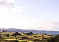
Farmland and view of Wicklow from above
-
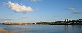
Wicklow Harbour
-
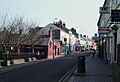
Main Street
-
Stone Bridge over the River Vartry
-

Golf course in Wicklow


See also
 In Spanish: Wicklow para niños
