
Snowdonia facts for kids
Quick facts for kids Snowdonia |
|
|---|---|
| Eryri (Welsh) | |
.jpg)
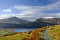
View of Llyn Cwellyn from the Snowdon Ranger path
|
|
| Highest point | |
| Peak | Snowdon |
| Elevation | 1,085 m (3,560 ft) |
| Dimensions | |
| Area | 2,130 km2 (820 sq mi) |
| Geography | |

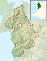
Relief map of Snowdonia, within the national park boundaries
|
|
| Location | North Wales |
| Country | Wales, United Kingdom |
| Geology | |
| Orogeny | Caledonian |
| Age of rock | Cambrian and Ordovician |
| Type of rock | |
| Snowdonia National Park Eryri National Park Parc Cenedlaethol Eryri (Welsh) |
|
|
IUCN Category V (Protected Landscape/Seascape)
|
|
| Location | Conwy & Gwynedd (Wales) |
| Area | 823 sq mi (2,130 km2) |
| Established | 1951 |
| Governing body | Snowdonia National Park Authority |
Snowdonia, also known as Eryri (pronounced [ɛrəri]), is a beautiful mountainous area in North Wales. It is also a special protected area called a national park. This park is home to all 15 mountains in Wales that are over 3,000 feet high. The tallest of these is Snowdon (Yr Wyddfa), which stands at 1,085 meters (3,560 feet) tall.
The highest peaks are found in the northern part of Snowdonia. These include the Snowdon, Glyderau, and Carneddau mountain ranges. Slightly to the south, you'll find the smaller Moelwynion and Moel Hebog ranges. The national park covers a large area of 823 square miles (2,130 square kilometers). It was the first of Wales's three national parks, created in October 1951.
Contents
What's in a Name?
The Meaning of "Snowdon"
The name "Snowdon" comes from Old English words. "Snāw" means "snow" and "dūn" means "hill". So, "Snowdon" means "snow hill". The name "Snowdonia" simply comes from the name of this famous mountain.
Understanding "Eryri"
The meaning of Eryri is a bit less clear. Some people think it's linked to eryr, which means 'eagle'. However, it's more likely that Eryri means 'highlands' or 'uplands'. It might be related to the Latin word oriri, meaning 'to rise'. This fits because Eryri is a plural word for 'uplands'.

Snowdonia National Park
How the Park Was Formed
Snowdonia National Park, also called Eryri National Park, was created in October 1951. It was the third national park in the United Kingdom. The first two were the Peak District and Lake District, both established earlier in 1951. Snowdonia National Park covers 827 square miles (2,142 square kilometers). It includes parts of Gwynedd and Conwy County Borough counties. It also has 37 miles (60 kilometers) of coastline.
Who Manages the Park?
The park is managed by the Snowdonia National Park Authority. This group has 18 members. Nine members are chosen by Gwynedd, three by Conwy, and six by the Welsh Government. Their main offices are in Penrhyndeudraeth.
Changing Names: Snowdonia to Eryri
Until recently, the park authority used "Snowdonia" and "Snowdon" in English. But in February 2023, they decided to mostly use the Welsh names: Eryri for the park and Yr Wyddfa for the mountain. For about two years, they will still use the English names in brackets, like "Yr Wyddfa (Snowdon)", to help people get used to the change.
Land Ownership in the Park
Unlike national parks in some other countries, UK national parks include both public and private land. Here's how the land is owned in Snowdonia National Park:
| Ownership type | Share (%) |
|---|---|
| Private | 69.9 |
| National Trust | 8.9 |
| National Park Authority | 1.2 |
| Natural Resources Wales | 17.5 |
| Water companies | 0.9 |
| Other | 1.6 |
More than 26,000 people live inside the park. In 2011, about 58.6% of them could speak Welsh. While much of the land is open mountains, there's also a lot of farming.
Blaenau Ffestiniog: An Excluded Town
The town of Blaenau Ffestiniog is a bit unusual. It's completely surrounded by the national park but is not actually part of it. This was done on purpose when the park was created. The town was a major center for slate quarrying, and its industry was kept separate from the park's protected areas.
The Land of Snowdonia
How Glaciers Shaped the Land

The rocks and landscape of Snowdonia are very special. Many thousands of years ago, during the ice ages, huge glaciers moved across the land. These glaciers carved out the rocky mountains and valleys we see today. The last ice age ended about 11,500 years ago. This created a beautiful landscape that attracts many visitors. In 1841, Charles Darwin visited Cwm Idwal and realized that glaciers had shaped the area.
Ancient Rocks and Slate
The main rocks in Snowdonia are from the Cambrian and Ordovician periods. These are very old rocks. Over time, some of the muddy rocks changed into slate. This slate was once very important for the area's economy. Many people worked in the slate quarries.
Mountains, Rivers, and Coastline
Famous Mountain Ranges
Snowdonia is known for its impressive mountains. The main ranges are the Snowdon massif (the area around Snowdon itself), the Glyderau, the Carneddau, the Moelwynion, and the Moel Hebog range. All of Wales's mountains over 3,000 feet are in the first three of these ranges. These are very popular with visitors.
Further south in the national park, you'll find the Rhinogydd, Cadair Idris, and Aran Fawddwy ranges. Snowdon's summit, at 1,085 meters (3,560 feet), is the highest point in Wales. It's also the highest in Britain outside of the Scottish Highlands.

Rivers and Lakes
Many rivers in Snowdonia flow directly into Cardigan Bay. These rivers are usually short and flow quickly down the mountains. Some important rivers include the Glaslyn, Dwyryd, and the Mawddach. Other rivers flow north, like the Conwy and Ogwen.
Snowdonia is also home to most of Wales's natural lakes. Bala Lake is the largest natural lake in Wales. Many lakes fill valleys carved by glaciers, like Llyn Padarn and Llyn Peris. There are also many small, round lakes called tarns. These formed in hollows left by glaciers. Examples include Llyn Llydaw and Glaslyn on Snowdon.
Some lakes have been made bigger or created by people. Llyn Celyn and Llyn Trawsfynydd are two large man-made lakes. In 2023, the park decided to use only the Welsh names for its lakes.
The Coastline
The national park meets the Irish Sea along Cardigan Bay. This coastline has many sand dunes, like Morfa Dyffryn and Morfa Harlech. These areas are important for wildlife. The northern part of the park reaches the north coast of Wales at Penmaen-bach Point, where tall cliffs meet the sea.
Towns and Villages
.jpg)
There are only three towns completely inside the park: Dolgellau, Bala, and Harlech. However, many other towns and villages are closely linked to the park. For example, Blaenau Ffestiniog is surrounded by the park but not part of it.
Other important places near the park include Tywyn and Barmouth on the coast. Towns like Conwy, Bethesda, and Llanberis in the north also rely on the park for tourism. Llanberis is where you can catch the Snowdon Mountain Railway.
Many smaller villages are popular with visitors, such as Betws-y-Coed, Aberdyfi, and Beddgelert.
Getting Around Snowdonia
Roads for Exploring
.jpg)
Six main roads serve Snowdonia. The A55 is a busy road along the north coast, providing access to the northern park. The A470 is a key north-south route, passing through Betws-y-Coed and Blaenau Ffestiniog. The historic A5, built by Thomas Telford, also runs through the park. Many other smaller roads wind through the mountains, offering scenic drives.
.jpg)
Railways in the Park
- The North Wales Coast Line runs along the northern edge of the park.
- The Conwy Valley Line goes south from Llandudno Junction, entering the park near Betws-y-coed. It ends at Blaenau Ffestiniog, where you can connect to the Ffestiniog Railway.
- The Cambrian Line runs along the coast from south to north, passing through towns like Aberdovey, Tywyn, and Barmouth. It crosses the Mawddach estuary on the famous Barmouth Bridge.
Many old railway lines are now used as paths for walking and cycling. The Bala Lake Railway is a special heritage railway that uses part of an old line.
Bus Services
The park has a growing bus network called Sherpa'r Wyddfa. This network, along with the TrawsCymru buses, helps tourists and locals travel around the park without a car. The Sherpa'r Wyddfa service was relaunched in 2022. It now uses Welsh place names to promote the Welsh language.
Weather in Snowdonia
.jpg)
Snowdonia is one of the wettest places in the United Kingdom. Crib Goch, a ridge on Snowdon, is the wettest spot. It gets about 4,473 millimeters (176 inches) of rain each year.
A Look Back in Time
Early Human Life
People have lived in Snowdonia for a very long time. The oldest signs of humans are from around 4000–3000 BC. You can still see traces of ancient field systems, old enclosures, and hut circles. There are also burial sites from the Neolithic and Bronze Age, and Iron Age hillforts.
Roman Times and Beyond
The Romans took over the region around AD 77–78. You can find remains of Roman camps and forts, like Tomen y Mur. Roman roads, including parts of Sarn Helen, connected the area to other Roman towns.
After the Romans left, early Christian memorial stones appeared. Churches were built in the 5th and 6th centuries. Welsh princes like Llywelyn the Great and Llywelyn ap Gruffudd built stone castles to protect their lands. Later, Edward I built more castles, like those at Harlech and Conwy. Many of these castles are now World Heritage Sites.
The Industrial Age
In the 18th century, people started to use the area's natural resources for industry. New roads made it easier to transport goods. Thomas Telford built many roads and railways. A new harbor at Porthmadog was linked to the slate quarries at Ffestiniog by a narrow-gauge railway.
At its peak in the 19th century, the slate industry employed about 12,000 men. Other people worked in stone, copper, iron, and gold mines. Today, you can still see the ruins of these old mines and mills.
Wildlife and Nature

The entire coastline of Snowdonia National Park is a Special Area of Conservation. This means it's a very important place for nature. The park has valuable sand dune systems.
The natural forests in the park are mostly deciduous trees, like the Welsh oak. You'll also find birch, ash, and hazel trees. There are also large areas of planted coniferous trees, like in Gwydir Forest.
Unique Plants of Snowdonia
Northern Snowdonia is a special place for plants. It's the only place in Britain where the Snowdon lily (Gagea serotina) grows. This plant is usually found in very cold, high places. It's also the only place in the world where the Snowdonia hawkweed Hieracium snowdoniense grows.

One big challenge for the park is the Rhododendron ponticum. This plant grows very fast and can take over, stopping native plants from growing. It can also make the soil toxic for other plants and animals for many years.
Animals of Snowdonia
You can find many interesting animals in the park. Mammals include otters, polecats, feral goats, and pine martens. Birds like ravens, choughs, peregrines, ospreys, merlins, and red kites live here. The colorful Snowdon beetle (Chrysolina cerealis) is found only in northern Snowdonia.
Protected Natural Areas
Snowdonia has many protected sites because of its diverse nature. Almost 20% of the park is protected by UK and European laws. Half of this area is a Special Area of Conservation. There are also many Sites of Special Scientific Interest (SSSIs), which protect plants, animals, and geology. Nineteen of these sites are managed as national nature reserves. The park also has twelve Special Areas of Conservation (SACs), three Special Protection Areas (SPAs), and three Ramsar sites.
Park Economy
Farming and Forests
For a long time, the economy of Snowdonia was based on farming, especially sheep farming. In the 20th century, many parts of the park were planted with trees for timber. Large conifer forests include Dyfi Forest and Coed y Brenin Forest.
Slate and Energy
The region was once the world's most important producer of slate. While some slate is still produced, it's much less than before. The park's boundaries were drawn to keep most of the slate quarrying areas outside the protected park.
Energy production is also part of the economy. A nuclear power station was built near Llyn Trawsfynydd in 1959 and operated until 1991. There are also pumped storage hydroelectric schemes at Llanberis and Ffestiniog, which use water to generate electricity.
Tourism in Snowdonia
Tourism has become a very important part of Snowdonia's economy. In 2013, about 3.67 million people visited the park. Visitors spent over £433 million that year.
Hiking and Walking

Many hikers come to climb Snowdon itself. It's a great mountain, but it can get very busy. You can also take the Snowdon Mountain Railway to the top.
Other popular mountains for hiking include the Glyderau and Carneddau ranges. Tryfan is also famous because you need to use your hands and feet to climb it! There are also many wonderful walks on the lower mountains that are less crowded. Some favorites include Y Garn, the Nantlle Ridge, Moelwyn Mawr, and Pen Llithrig y Wrach. Further south, you can explore Y Llethr in the Rhinogydd and Cadair Idris.
The park has 1,479 miles (2,380 kilometers) of public footpaths and many other public routes. A large part of the park also has "right to roam" laws, meaning you can walk freely.
Long-Distance Trails
The Wales Coast Path runs through parts of the park along the coast. The North Wales Path also enters the park and visits places like Aber Falls. The Cambrian Way is a long-distance trail from Cardiff to Conwy that stays almost entirely within Snowdonia National Park from the south. It was officially recognized in 2019.
Using Welsh Names
.jpg)
There has been a lot of discussion about using the English names "Snowdon" and "Snowdonia" versus the Welsh names Yr Wyddfa and Eryri. Since 2020, there have been more calls to use the Welsh names.
In November 2022, the Snowdonia National Park Authority decided to use Yr Wyddfa and Eryri for the mountain and the park in their materials. They said that Welsh place names are a special part of the area. Before this decision, the park already put Welsh names first, with English names in brackets. The name "Snowdonia" cannot be completely removed because it's set in law for official documents.
Images for kids
-
Relief map of Snowdonia, within the national park boundaries
-
View of Llyn Cwellyn from the Snowdon Ranger path
-

Snowdonia National Park logo
See also
 In Spanish: Eryri para niños
