
Snowdon Massif facts for kids

The Snowdon Massif is a group of tall mountains in Snowdonia, located in north Wales. It's one of three mountain areas in Snowdonia that have peaks over 3,000 feet (which is about 914 meters) high. This mountain area is found between the towns of Beddgelert, Pen-y-Pass, and Llanberis. It's surrounded by other mountain ranges like the Glyderau to the northeast and the Moelwynion to the south. To the northwest, the land becomes flatter and leads towards Caernarfon and the Menai Strait.
The Snowdon Horseshoe is a special name for a half-circle shape made by ridges and peaks on the eastern side of Snowdon. It looks out over a valley called Dyffryn Mymbyr towards Capel Curig. The main peaks that form this famous Horseshoe are Y Lliwedd, Snowdon itself, Garnedd Ugain, and Crib Goch.

Contents
Discovering the Snowdon Massif
The Snowdon Massif is a very popular place for hikers and climbers. It's known for its amazing views and challenging trails. Many people visit each year to explore its beautiful landscapes and reach the top of its famous peaks.
What is a Mountain Massif?
A "massif" is a group of mountains that are connected and form a compact block. Think of it like a big, solid chunk of mountains. The Snowdon Massif is a great example of this, with several high peaks close together.
Famous Peaks of Snowdon
The Snowdon Massif is home to some of the highest and most well-known mountains in Wales. Here are some of the important peaks you can find there:
- Snowdon (also called Yr Wyddfa) - This is the tallest mountain in Wales, standing at 1,085 meters (3,560 feet) high.
- Garnedd Ugain (also called Crib y Ddysgl) - This peak is 1,065 meters (3,494 feet) tall.
- Crib Goch - This mountain is 923 meters (3,028 feet) high and is famous for its narrow, rocky ridge.
- Y Lliwedd - This peak reaches 898 meters (2,946 feet) in height.
- Yr Aran - Standing at 747 meters (2,451 feet).
- Moel Eilio - This peak is 726 meters (2,382 feet) high.
- Moel Cynghorion - This mountain is 674 meters (2,211 feet) tall.
- Foel Gron - This peak is 629 meters (2,064 feet) high.
The Snowdon Horseshoe Trail
The Snowdon Horseshoe is a very famous and exciting walking route. It's a challenging path that takes you over four main peaks: Y Lliwedd, Snowdon, Garnedd Ugain, and Crib Goch. It's known for its stunning views and for being a bit tricky in places, especially the narrow ridge of Crib Goch. Many experienced hikers love to complete this route.
Images for kids
-
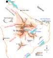
A sketch map of the Snowdon massif. The black lines show ridges, dotted red lines are paths, orange lines are roads, and the grey line is the Snowdon Mountain Railway.

