Glyder Fawr facts for kids
Quick facts for kids Glyder Fawr |
|
|---|---|

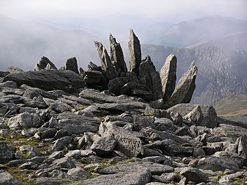
Rocky outcrop near the summit of Glyder Fawr
|
|
| Highest point | |
| Elevation | 1,001 m (3,284 ft) |
| Prominence | 642 m (2,106 ft) |
| Parent peak | Snowdon |
| Listing | Marilyn, Hewitt, Welsh 3000s, Nuttall, Furth |
| Naming | |
| English translation | Big Lump |
| Language of name | Welsh |
| Pronunciation | Welsh: [ˈɡlɪdɛr ˈvau̯r] |
| Geography | |
| Location | Gwynedd / Conwy, Wales |
| Parent range | Snowdonia |
| OS grid | SH642579 |
| Topo map | OS Landranger 115 / Explorer OL17 |
Glyder Fawr is a tall mountain in Snowdonia, Wales. It's the highest peak in the Glyderau mountain range, standing just over 1,000 meters (about 3,280 feet) high. This makes it the fifth-tallest mountain in all of Wales! Many people enjoy hiking and climbing its paths to reach the top. The name "Glyder" comes from an old Welsh word, "Gludair," which means "a heap of stones." This is a perfect name for a rocky mountain!
Contents
Exploring Glyder Fawr
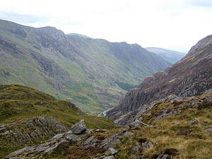
Glyder Fawr is part of the Glyderau mountain range. This range sits northeast of the famous Snowdon mountain. A deep valley called the Llanberis Pass and the Nant Peris Valley separate them.
The Glyderau Mountain Family
The Glyderau range includes several other impressive peaks. From west to east, you'll find:
- Elidir Fawr (924 meters or 3,031 feet)
- Y Garn (947 meters or 3,107 feet)
- Glyder Fawr (1,001 meters or 3,284 feet)
- Glyder Fach (994 meters or 3,261 feet)
- Tryfan (918 meters or 3,012 feet)
North of the Glyderau are the Carneddau mountains. The Ogwen Valley and the Nant Ffrancon Valley separate these two ranges. Because the Glyderau are set apart, they offer amazing views of the surrounding peaks and valleys.
How Tall Is It Really?
For a long time, maps showed Glyder Fawr as 999 meters tall. But in late 2010, experts used special GPS equipment to measure it again. They found its true height is 1,000.8 meters (about 3,284 feet)! This new height made the mountain officially over 1,000 meters. People at the Snowdonia National Park Authority were happy, hoping it would attract even more hikers.
How the Mountains Were Made
The Glyderau mountains formed about 500 million years ago. This happened when two huge land masses crashed into each other, pushing up the land to create the Snowdonia area. Over millions of years, wind, water, and frost slowly shaped the mountains. Giant sheets of ice, called glaciers, also moved across the land during the ice ages. These glaciers carved out valleys and smoothed parts of the mountains.
The last ice age ended about 10,000 years ago. It left behind amazing features like Cwm Idwal, which is a bowl-shaped valley carved by ice. The ice also scraped the cliffs, dug out the bed of Llyn Idwal lake, and left piles of rocks called moraines. Today, you can still see huge rocks and shattered stones that fell from above, forming rocky fields and slopes.
Paths to the Top
You can reach the summit of Glyder Fawr from different directions. Each route offers a unique adventure!
Starting Your Climb
- One path begins at Ogwen Cottage near Llyn Idwal lake, approaching the mountain from the north.
- Another route starts at Pen-y-Pass and comes from the south.
- You can also approach from the east, walking along the ridge from Glyder Fach. Even though Glyder Fach has many broken stones near its top, the path between Glyder Fach and Glyder Fawr is mostly flat and easy to walk.
A Challenging Circuit
For experienced hikers, there's a challenging route that includes three peaks: Tryfan, Glyder Fach, and Glyder Fawr. This exciting journey takes about six or seven hours to complete.
The Popular Ogwen Route
One of the most popular ways to climb Glyder Fawr starts at Ogwen Cottage. This path follows the shore of Llyn Idwal. It then goes past the famous Rhiwiau Caws (Idwal Slabs), which is a popular spot for rock climbing. The path then climbs out of the valley using the steep Twll Du path, leading to a small lake called Llyn Y Cŵn. From there, a steep, rocky path goes up the western side to the very top of Glyder Fawr.
Caring for the Mountains
The National Trust helps look after the Glyderau and Carneddau mountains. They took over this important job in 1951.
Protecting the Land
The National Trust manages about 7,000 hectares (about 17,300 acres) of land in this area. About half of this land is "common land." This means local farmers have rights to let their animals, like 45,000 sheep and 741 ponies, graze there. The National Trust also maintains the footpaths and stone walls, some of which are hundreds of years old. Both the Glyderau and Carneddau ranges are part of the beautiful Snowdonia National Park.
 | George Robert Carruthers |
 | Patricia Bath |
 | Jan Ernst Matzeliger |
 | Alexander Miles |


