Glyderau facts for kids
Quick facts for kids Glyderau |
|
|---|---|

|
|
| Highest point | |
| Peak | Glyder Fawr |
| Elevation | 1,000.8 m (3,283 ft) |
| Naming | |
| Etymology | From the Welsh word "Cludair", meaning a heap of stones |
| Geography | |
| Country | Wales |
| State/Province | Snowdonia |
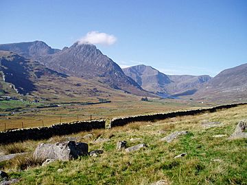
The Glyderau (say "Glid-er-eye") is a group of mountains in Snowdonia, North Wales. People also call them the Glyders in English. Their name comes from the two tallest peaks in the range: Glyder Fawr and Glyder Fach. The word "Glyder" comes from an old Welsh word, "Cludair," which means "a heap of stones."
The Glyderau mountains stretch from Mynydd Llandegai all the way to Capel Curig. This area has five of Wales' highest mountains, which are over 3,000 feet tall. One of these is Tryfan, which many people think is one of the best mountains in Wales. To reach the top of Tryfan, you need to do some scrambling, which is like climbing using both your hands and feet. The eastern part of the Glyderau, including Glyder Fawr, Glyder Fach, and Tryfan, is very popular for hiking and climbing.
Inside Elidir Fawr, one of the Glyderau mountains, there is a special power station called Dinorwig Power Station. It's a hydroelectric system that uses water to make electricity. The Glyderau area also has a beautiful lake called Llyn Idwal. You can find many famous climbing spots here, like Rhiwiau Caws.
Contents
How the Glyderau Mountains Formed
The Glyderau mountains started forming about 500 million years ago. This was during a time called the Ordovician period. Two huge pieces of land slowly moved towards each other. This movement caused the land to push up and create the Snowdonia mountains.
Over millions of years, wind, rain, and ice have shaped these mountains. Huge sheets of ice, called glaciers, moved across the land during the Ice Ages. They carved out valleys and smoothed down the mountains. The last big ice sheet left about 10,000 years ago.
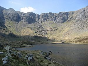
You can see how the ice shaped the land in places like Cwm Idwal. This valley looks like a giant bowl and was formed by a glacier. The ice also left behind big rocks and piles of dirt called moraines.
Plants and Animals of the Glyderau
Long ago, the Glyderau mountains were covered in forests. These forests had trees like birch and oak. But over thousands of years, early farmers cleared most of these trees. Now, there are not many trees left.
You might still see groups of wild goats living on the Glyderau. These goats are probably descendants of farm animals from a very long time ago. In the 1700s, many sheep were brought to the area. This was because the wool industry became very important. Today, lots of sheep still graze on the mountain slopes.
Visiting the Glyderau
The Glyderau mountains look very rocky compared to the smoother mountains nearby. The path between the peaks of Glyder Fawr and Glyder Fach is covered with grass, heather, and many large rocks. Climbing Tryfan is more challenging than just walking; it requires you to use your hands and feet.
Tryfan, Glyder Fach, and the cliffs around Cwm Idwal are great for rock climbing. There are climbing routes for everyone, from beginners to very experienced climbers. You can start your mountain adventure from Llyn Ogwen in the north, where there's a car park. Another way to get there is from Nant Peris in the Llanberis Pass. There's a special bus service that takes you from the car park to the mountains. Buses also run from Bangor to Llanberis, and from Bethesda to Llyn Ogwen.
Cwm Idwal: A Special Valley
Cwm Idwal is a unique valley that faces north and has dark, tall cliffs. It's home to some very rare plants. Some of these plants are remnants of Arctic/Alpine plants, meaning they usually grow in very cold, high places. The Snowdon lily (Lloydia serotina) grows here, high on mountain ledges. This is the only place in Britain where you can find it!
Other special plants include the purple saxifrage (Saxifraga oppositifolia) and the Alpine meadow rue (Thalictrum alpinum). Because of its amazing plants, Cwm Idwal has been made a national nature reserve. Sheep are not allowed to graze here, so the native plants can grow freely.
The lake in the valley, Llyn Idwal, is shallow. Its edges are lined with plants like rushes and reeds. You can also find plants like awlwort and spring quillwort (Isoetes echinospora) growing in the water or damp ground.
Many animals live in Cwm Idwal too. You might spot badgers, foxes, and polecats. Birds like buzzards (Buteo buteo), peregrine falcons (Falco peregrinus), and choughs (Pyrrhocorax pyrrhocorax) fly overhead.
Legends of Cwm Idwal
In the cliffs above Llyn Idwal, there's a dark crack called Twll Du. Sometimes, mist comes out of it. People used to believe that ancient druids made this mist to create lightning bolts. They thought the druids did this to keep the invading Romans away.
Llyn Idwal itself has a sad story behind its name. It's said to be named after a boy who drowned in the lake. Some stories say he was the son of an 8th-century prince, murdered by a rival. Other stories say he was the son of Prince Owain Gwynedd from the 12th century, killed by his uncle. An old traveler named Thomas Pennant wrote in the 1780s that local shepherds were scared of the lake. They believed it was "the haunt of Daemons" and that no bird would dare fly over its "damned waters."
Dinorwig Power Station: Power Inside the Mountain
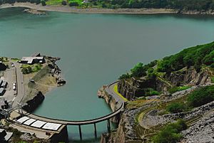
Deep inside the mountain of Elidir Fawr, there's a huge power station with many miles of tunnels. This is Dinorwig Power Station. It's a special kind of hydroelectric power plant called a pumped storage facility. It helps store energy and balance out the electricity supply.
When there isn't much demand for electricity, water is pumped up the mountain. It's stored in a reservoir called Marchlyn Mawr, which used to be a slate quarry. Then, when people need a lot of electricity, the water is released. It flows down through giant turbines, which create power. The electricity travels through underground cables. This way, the power station doesn't spoil the beautiful views of the Snowdonia National Park.
Caring for the Glyderau
The National Trust helps manage the Glyderau mountains. They started looking after this area in 1951. The total area they manage is about 7,000 hectares. A large part of this land is common land, where farmers have the right to let their sheep and ponies graze.
The National Trust is responsible for keeping the footpaths in good condition. They also look after the old stone walls, some of which are hundreds of years old. The Glyderau mountains are part of the Snowdonia National Park.
Mountains in the Glyderau Range
Here are some of the main peaks in the Glyderau mountains, listed from west to east:
- Elidir Fawr (924 meters)
- Carnedd y Filiast (821 meters)
- Mynydd Perfedd (813 meters)
- Foel Goch (831 meters)
- Y Garn (947 meters)
- Glyder Fawr (1,001 meters)
- Glyder Fach (994 meters)
- Tryfan (918 meters)
- Y Foel Goch (805 meters)
- Gallt yr Ogof (763 meters)
- Cefn y Capel (about 460 meters)
 | Jessica Watkins |
 | Robert Henry Lawrence Jr. |
 | Mae Jemison |
 | Sian Proctor |
 | Guion Bluford |


