
Elidir Fawr facts for kids
Quick facts for kids Elidir Fawr |
|
|---|---|

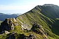
Elidir Fawr from Mynydd Perfedd with Marchlyn Mawr below
|
|
| Highest point | |
| Elevation | 924 m (3,031 ft) |
| Prominence | 212 m (696 ft) |
| Parent peak | Y Garn |
| Listing | Marilyn, Hewitt, Welsh 3000s, Nuttall, Furth |
| Geography | |
| Location | Gwynedd, UK |
| Parent range | Snowdonia |
| OS grid | SH612613 |
| Topo map | OS Landranger 115 |
Elidir Fawr is a cool mountain in Snowdonia, North Wales. It is the most northern peak in a mountain range called the Glyderau. This mountain is 924 meters (about 3,031 feet) tall.
To the north of the mountain's top is a small lake called Marchlyn Mawr. This lake is like a giant battery! It is the upper reservoir for the Dinorwig power station. This special power station is hidden inside the mountain itself. Water from this lake flows through huge tunnels. It goes down to a lower reservoir called Llyn Peris. From the north, Elidir Fawr looks very big. It can even seem taller than other mountains behind it.
Hidden Power Station
Inside Elidir Fawr, there is a secret. It is home to the Dinorwig power station. This is a special type of pump-storage power station. It makes electricity using water.
When there is extra electricity, the station pumps water from Llyn Peris up to Marchlyn Mawr. When more electricity is needed, the water rushes back down. It spins giant turbines to create power. This makes the mountain a very important part of Wales's energy supply.
Old Slate Quarries
If you look at Elidir Fawr from Llanberis, you will see something interesting. The mountain is covered by the old Dinorwic slate quarries. These quarries were once very busy places. Workers dug out huge amounts of slate from the mountain. Slate was used for roofs and other building materials. The quarries left behind big piles of waste rock. They show a long history of mining in the area.
Exploring Elidir Fawr
Climbing Elidir Fawr is a fun adventure. It is a short but steep walk to the top. You can start your walk from the Deiniolen side. This path gives you great views down to Llanberis. Another way to start is from Nant Peris. This route is also steep but quite short.
You can also reach the top from Ogwen Cottage. This way involves walking across Y Garn and Foel-goch. The path goes around Cwm Dudodyn. Then it leads up to the rocky top of Elidir Fawr. From the summit, you get amazing views of the surrounding mountains and lakes.

Images for kids
-
Elidir Fawr ridge, as seen from the ridge along Mynydd Perfedd, above the reservoir, with Moel Cynghorion in the background

