
Mynydd Perfedd facts for kids
Quick facts for kids Mynydd Perfedd |
|
|---|---|

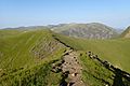
Mynydd Perfedd seen from Foel-goch
|
|
| Highest point | |
| Elevation | 813 m (2,667 ft) |
| Prominence | 20 m (66 ft) |
| Listing | sub Hewitt, Nuttall |
| Naming | |
| Language of name | Welsh |
| Geography | |
| Location | Gwynedd, Wales |
| Parent range | Glyderau |
| OS grid | SH623619 |
| Topo map | OS Landranger 115, OS Outdoor Leisure 17 |
| Climbing | |
| Easiest route | Walk |
Mynydd Perfedd is a mountain in Snowdonia, a beautiful national park in Wales. It is part of a mountain range called the Glyderau. This mountain is 813 meters (about 2,667 feet) tall. From its top, you can see amazing views of other mountains like Foel-goch and the Carneddau range.
Exploring Mynydd Perfedd
Mynydd Perfedd is a great place for walking and exploring. At the very top, there's a small stone shelter. This cairn helps protect you from the wind while you enjoy the scenery. The average temperature on the mountain is around 5 degrees Celsius (41 degrees Fahrenheit).
Nearby Mountains and Features
Mynydd Perfedd is surrounded by other impressive peaks. To the south, you'll find Elidir Fawr, which is its "parent peak" because it's taller. To the west is Carnedd y Filiast, and to the east are Foel-goch and Y Garn.
Between Mynydd Perfedd and Carnedd y Filiast, there are dramatic cliffs. These cliffs are very steep and rugged. One famous part of these cliffs is known as the "Atlantic Slab," which is popular with climbers.
Images for kids
-
Mynydd Peredd as seen from the ridge along Elidir Fawr, above the reservoir, with the Carneddau in the background

