
Snowdon facts for kids
Quick facts for kids Snowdon |
|
|---|---|
| Yr Wyddfa (Welsh) | |

The Snowdon group viewed from the north-east
left to right Y Lliwedd, Crib Goch, Yr Wyddfa (the summit), Garnedd Ugain |
|
| Highest point | |
| Elevation | 1,084.74 m (3,558.9 ft) |
| Prominence | 1,039 m (3,409 ft) Ranked joint 3rd in British Isles |
| Parent peak | Ben Nevis |
| Listing | Marilyn, Ribu, Furth, Hewitt, Nuttall, Welsh 3000s, council top, |
| Geography | |

Snowdon
Location in Gwynedd

Snowdon
Location in Wales

Snowdon
Location in the United Kingdom
|
|
| Parent range | Snowdonia |
| OS grid | SH6098954379 |
| Topo map | OS Landranger 115, Explorer OL17 |
| Climbing | |
| Easiest route | Llanberis Path |
| Listed summits of Snowdon | ||||
| Name | Grid ref | Height | Status | |
|---|---|---|---|---|
| Crib y Ddysgl | SH610551 | 1,065 m (3,494 ft) | Welsh 3000s, Hewitt, Nuttall | |
| Crib Goch | SH624551 | 923 m (3,028 ft) | Welsh 3000s, Hewitt, Nuttall | |
| Craig Fach | SH635552 | 609 m (1,998 ft) | sub-Hewitt | |
| Craig Wen | SH597508 | 605 m (1,985 ft) | sub-Hewitt | |
Snowdon (also known as Yr Wyddfa in Welsh) is a famous mountain in North Wales. It stands tall in an area called Snowdonia. At 1,085 meters (3,560 feet) above sea level, it is the highest mountain in all of Wales. It is also the tallest peak in the British Isles outside of Scotland.
Snowdon is a special place. It is a national nature reserve. This means it protects rare plants and animals. The mountain is also part of the larger Snowdonia National Park.
The rocks of Snowdon were made by volcanoes a very long time ago. Later, huge glaciers carved out its shape. They created its pointy top and sharp ridges like Crib Goch. Many lakes can be found on the mountain. The biggest is Llyn Llydaw, which is about 45 hectares (110 acres) in size.
Snowdon is a very popular mountain. Over half a million people walked up it in 2022. There are six main paths to the top. You can also ride the Snowdon Mountain Railway. This special train has been running since 1896. It takes visitors almost 8 kilometers (4.75 miles) from Llanberis to the summit. The steep cliffs of Snowdon are also famous for rock climbing. Even Edmund Hillary, who first climbed Mount Everest, trained here!
Contents
Understanding Snowdon's Names

The name "Snowdon" comes from Old English words. It means "snow hill." This name was first written down in 1095.
The Welsh name for the mountain is Yr Wyddfa. This name was first recorded in 1284. It means "the burial mound" or "the height." There is a legend that a giant named Rhitta Gawr is buried under the mountain's top. Some stories say King Arthur defeated and buried Rhita there. Other tales link Snowdon to water monsters and fairies.
You might hear the mountain called "Mount Snowdon." However, many people prefer just "Snowdon" or its Welsh name. This is because there is another "Mount Snowdon" in Canada.
In November 2022, the Snowdonia National Park decided to use the Welsh name Yr Wyddfa for the mountain. They also chose to use Eryri for the national park. This change helps celebrate Welsh culture. By November 2024, many businesses and media had started using the Welsh names.
Snowdon's Environment
Mountain Shape and Rocks

Snowdon is the highest mountain in Wales. It is also the tallest in the British Isles outside of Scotland. Its summit is 1,085 meters (3,560 feet) high.
The rocks that make up Snowdon were formed during the Ordovician Period. This was about 458 to 457 million years ago! At that time, volcanoes erupted and created thick layers of ash. The top of Snowdon is near where an ancient volcano once stood.
Over millions of years, huge glaciers moved across the land. They carved out the mountain's dramatic shape. This created the pointy peak of Snowdon. It also formed the sharp, narrow ridges like Crib Goch. You can still see other signs of glaciers today, like smooth rocks and piles of debris.
Weather on the Mountain
Snowdon often has snow in winter, which is how it got its English name. The amount of snow can change a lot each year.
The slopes of Snowdon are one of the wettest places in Great Britain. They get more than 5,000 millimeters (200 inches) of rain every year. So, if you visit, be prepared for wet weather!
Plants and Animals

Snowdon is home to many special plants. Some, like the "Snowdon lily" (Gagea serotina), are very rare in Britain. You can also find this lily in the Alps and North America. The mountain's eastern side is a national nature reserve to protect these unique plants.
Many animals live around Snowdon too. You might spot otters, polecats, and goats. Birds like ravens, choughs, and peregrines fly overhead. You might even see a red kite!
Snowdon's Lakes

Several beautiful lakes fill the valleys around Snowdon:
- Llyn Llydaw is the largest and deepest lake. It is 436 meters (1,430 feet) high and 45 hectares (110 acres) wide. It can be up to 58 meters (190 feet) deep! The lake's name might come from the Welsh word for "ash" or "Brittany." A causeway built in 1853 crosses the lake.
- Glaslyn is higher up than Llyn Llydaw, at 600 meters (1,970 feet). It is 7 hectares (18 acres) wide and 39 meters (127 feet) deep. People once thought it was bottomless! Many myths are linked to this lake.
- Llyn Ffynnon-y-gwas is 436 meters (1,430 feet) high and 4 hectares (10 acres) wide. It is near the Snowdon Ranger path. This lake was once made bigger to supply water to slate quarries.
Other smaller lakes include Llyn Du'r Arddu and Llyn Teyrn.
Fun Activities on Snowdon
Snowdon is known as "the busiest mountain in Britain." In 2022, over 543,000 people walked to its summit. There are six main walking paths. You can combine them for different adventures. The "Snowdon Horseshoe" is a challenging circular walk. It includes climbing over Crib Goch and Y Lliwedd.
It is important to remember that climbing Snowdon can be dangerous, especially in winter. The Llanberis Mountain Rescue Team warns that special skills and equipment are needed in icy conditions. Many people have been hurt or lost their lives on the mountain. Always be prepared and know your limits.

On clear days, you can see Snowdon from far away. It is visible from Manchester Airport and Liverpool John Lennon Airport. You can even see it from Dublin, Ireland!
Sometimes, many people visit Snowdon at once. In 2021, there were so many visitors that people had to wait in line. They would queue for over 45 minutes just to take a photo at the summit!
Rock Climbing Adventures

The cliffs of Snowdon are very important for rock climbing in the UK. One famous spot is Clogwyn Du'r Arddu, often called 'Cloggy'. The first recorded climb in Britain happened here in 1798. Climbers Peter Bailey Williams and William Bingley were looking for rare plants. Today, 'Cloggy' is one of Britain's best climbing cliffs.
Y Lliwedd was also explored by early climbers. It even had one of Britain's first climbing guides written about it in 1909. Edmund Hillary and his team trained on Snowdon before their successful climb of Mount Everest in 1953.
Walking Paths to the Top

The first recorded climb of Snowdon was by a botanist named Thomas Johnson in 1639. However, people might have climbed it even earlier. A historian mentioned a celebration on the mountain after King Edward I took over Wales in 1284.
There are six main paths to the summit. They were mapped by Google in 2015. Each path has a different length and steepness. Remember, these routes become much harder and more dangerous in winter.

Llanberis Path
This is the longest path, about 6.8 kilometers (4.2 miles) long. It gains 965 meters (3,166 feet) in height. The path follows the railway line. It is considered the easiest way up. This route is used for the annual Snowdon Race. The record time for this race is less than 40 minutes to the summit!
A part of this path, called the "Killer Convex," can be very dangerous in icy conditions. Uncareful walkers can slip over cliffs.
Snowdon Ranger Path

This path is 6.3 kilometers (3.9 miles) long. It starts near Llyn Cwellyn on the west side of the mountain. It is thought to be the oldest path to the summit.
The route starts with zigzags, then crosses a flat, wet area. It then climbs along a ridge towards the summit. This path meets several other routes just below the top.
Rhyd Ddu Path
This path is 5.8 kilometers (3.6 miles) long. It starts from the village of Rhyd Ddu on the west side. It is one of the easier routes and less crowded. You can see the summit from the very start of this path.
The path climbs gently onto a wide ridge. It then gets steeper as it nears the summit. It joins the Watkin Path close to the top.
Watkin Path

This is the most challenging direct route. It is 6.2 kilometers (3.9 miles) long. It starts at the lowest point and is the steepest. It was created by Sir Edward Watkin and opened in 1892.
The Watkin Path starts in beautiful woodlands. It then climbs past waterfalls and old slate quarries. Near the path, you can see Gladstone Rock. This rock has a plaque remembering a speech by Prime Minister William Ewart Gladstone in 1892.
Over Y Lliwedd
This route is about 6.4 kilometers (4 miles) long. It is often used for coming down the mountain. It is part of the Snowdon Horseshoe walk. This path follows the Watkin Path for a bit, then goes along the ridge of Y Lliwedd. It then drops down to join the Miners' Track.
Miners' Track

This path is 6.6 kilometers (4.1 miles) long. It starts at the Pen-y-Pass car park. It is the least steep overall. The path goes past Llyn Teyrn and crosses a causeway over Llyn Llydaw. It then climbs steeply to Glaslyn. You will see old mine buildings along this path.
Pyg Track

The Pyg Track is 5.3 kilometers (3.3 miles) long. It also starts from Pen-y-Pass. It climbs over a pass called Bwlch y Moch. It then goes along the lower slopes of Crib Goch. Above Glaslyn, it joins the Miners' Track for the final climb to the summit ridge.
No one is completely sure why it is called the Pyg Track. It might be named after Bwlch y Moch (Pigs' Pass). Or it could be from the Welsh word 'pyg' (black tar), which was carried to the copper mines.
Crib Goch
This route is about 5.0 kilometers (3.1 miles) long. Climbing Crib Goch is considered a serious mountaineering route. It is a very narrow and rocky ridge. It is part of the Snowdon Horseshoe walk. After crossing the Crib Goch ridge, it climbs to Garnedd Ugain before joining the Llanberis path. This route is only for experienced climbers.
Snowdon Mountain Railway

The Snowdon Mountain Railway (SMR) is a special train. It has a narrow track and uses a rack-and-pinion system to climb the steep mountain. It travels almost 8 kilometers (4.75 miles) from Llanberis to the summit. It is the only public rack railway in the United Kingdom.
The railway opened in 1896 and is still very popular. It carries over 130,000 passengers each year. Trains are pushed up the mountain by either steam or diesel engines. Building the railway cost about £63,800 back then. That would be like millions of pounds today!
The Summit of Snowdon
| Hafod Eryri | |
|---|---|

Hafod Eryri (2009)
|
|
| General information | |
| Address | via Snowdon Mountain Railway, Llanberis, Caernarfon, Gwynedd, LL55 4TY |
| Coordinates | 53°04′08″N 4°04′32″W / 53.068865°N 4.075588°W |
| Elevation | 1,065 m (3,494 ft) |
| Opened | 12 June 2009 |
| Cost | £8.4m |
| Design and construction | |
| Architecture firm | Ray Hole Architects |
| Structural engineer | Arup |
| Main contractor | Carillion |
| Awards and prizes | RIBA Welsh Architecture Award 2010 |
The first building at Snowdon's summit was put up in 1838. It sold refreshments to visitors. In 1896, when the railway opened, a new station building was planned. A new, larger building with a cafe was finished in 1937.
Over time, this building became old and worn out. Prince Charles even called it "the highest slum in Wales." So, a plan was made to replace it. The old building was taken down in 2006.
A brand new visitor center, called Hafod Eryri, opened on June 12, 2009. It cost £8.4 million to build! The Welsh National Poet, Gwyn Thomas, wrote a special poem for the building. It says, "The summit of Snowdon: You are, here, nearer to Heaven." Hafod Eryri means "upland summer residence of Snowdonia" in Welsh.
At the very top, there is a summit pillar built in 2001. It has a brass plate showing 100 different places you can see on a clear day. These include mountains in Ireland and the Lake District in England.
Today, parts of Snowdon and its summit are owned by the Snowdonia National Park Authority and the National Trust.
Snowdon in Welsh Stories

In Welsh folklore, the top of Snowdon is said to be the tomb of Rhitta Gawr, a giant. This is why the Welsh name Yr Wyddfa means "the burial mound." Rhitta Gawr wore a cloak made of men's beards! King Arthur is said to have defeated him.
Other places on Snowdon are linked to King Arthur. Bwlch y Saethau is a ridge where Arthur is said to have died. His sword, Excalibur, was thrown into Glaslyn. Then, Arthur's body was placed in a boat and taken to Afallon. His men are said to sleep in a cave on Y Lliwedd, waiting to be needed again.
Glaslyn is also where a water monster called an afanc (Welsh for beaver) was finally put to rest. This monster had caused trouble in the Conwy valley.
There is a large stone called Maen Du'r Arddu. It is said to have magical powers. Legend says if two people spend the night there, one will become a great poet and the other will go mad!
Snowdon in Art
-
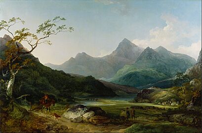
Snowdon from Capel Curig by Philip James de Loutherbourg, 1787
-
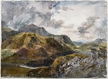
Snowdon and Dinas Emrys from Above Beddgelert – William Turner – Tate Britain

_Snowdon_and_Dinas_Emrys_from_above_Beddgelert_-_William_Turner_-_Tate_Britain.jpg)
Safety on Snowdon
Climbing Snowdon can be dangerous. In 2021, four people lost their lives on the mountain. It is very important to be prepared and careful. Always check the weather forecast. Wear proper clothing and footwear. Make sure you have enough food and water.
In 2021, two people were hurt by lightning on top of Snowdon. They had to be taken to the hospital. Always seek shelter if a storm approaches.
Using the Name Yr Wyddfa
In April 2021, there was a discussion about using the Welsh name Yr Wyddfa instead of Snowdon. Some people wanted the Gwynedd Council to officially use only the Welsh names. However, the National Park already had a group looking into using Welsh names.
In November 2022, the Snowdonia National Park Authority voted to use Yr Wyddfa and Eryri in their official communications. This means they will use the Welsh names for the mountain and the park. However, legal documents will still need both Welsh and English names.
By November 2024, the park authority said the name change was a "success." Many businesses and news outlets had started using the Welsh names. A survey showed that both locals and visitors supported the change. The park feels this helps connect the area more with its Welsh identity. They plan to create a guide to help people pronounce the Welsh names correctly.
See also
 In Spanish: Snowdon para niños
- Ben Nevis
- Mountains and hills of Scotland
- Scafell Pike
- Slate industry in Wales
