Scafell Pike facts for kids
Quick facts for kids Scafell Pike |
|
|---|---|

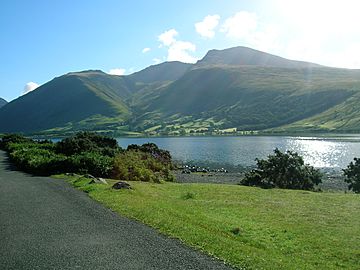
Scafell Pike viewed from Wastwater
|
|
| Highest point | |
| Elevation | 978 m (3,209 ft) |
| Prominence | 912 m (2,992 ft) Ranked 13th in British Isles |
| Listing | Marilyn, Hewitt, Wainwright, County Top, Nuttall, Country high point |
| Geography | |
|
Lua error in Module:Location_map at line 420: attempt to index field 'wikibase' (a nil value).
|
|
| Parent range | Lake District, Southern Fells |
| OS grid | NY215072 |
| Topo map | OS Landrangers 89, 90, Explorer OL6 |
Scafell Pike is the tallest mountain in England. It stands at 978 meters (3,209 feet) high. You can find it in the beautiful Lake District National Park in Cumbria.
Sometimes, people get Scafell Pike mixed up with a nearby mountain called Scafell. The name Pikes of Sca Fell was first used for a group of peaks. These peaks are now known as Scafell Pike, Ill Crag, and Broad Crag. The shorter name Scafell Pike became popular by mistake. It first appeared on an Ordnance Survey map.
In 1919, Lord Leconfield gave the summit of Scafell Pike to the National Trust. He did this to remember the brave men from the Lake District. They fought and died in World War I for "God and King, for freedom, peace and right."
A study by the National Trust in 2014 found something amazing. About 100,000 people climb Scafell Pike every year!
Contents
Exploring Scafell Pike's Shape
Scafell Pike is part of a group of high hills, called fells. These fells form a horseshoe shape around the top of Eskdale, Cumbria. Scafell Pike is on the western side of this horseshoe. To its south is Scafell, and to its north is Great End. This ridge acts like a natural wall. It separates Eskdale from Wasdale, which is on the west side.
The very top part of Scafell Pike starts at a ridge called Mickledore in the south. It includes a wide, rocky area at the summit. It then goes down to a dip called Broad Crag Col. Many guidebooks also include two other peaks as part of Scafell Pike. These are Broad Crag, which is 934 meters (3,064 feet) tall, and Ill Crag, which is 935 meters (3,068 feet) tall.
Scafell Pike also has smaller peaks nearby. Lingmell, to the northwest, is usually seen as a separate fell. Pen, which is 760 meters (2,500 feet) tall, is a shapely peak above the Esk river. It is usually thought of as a smaller part of Scafell Pike. Middleboot Knotts is another peak on the Wasdale side of Broad Crag. It is listed as a Nuttall.
The rocky top of Scafell Pike has steep cliffs on all sides. These include Pikes Crag and Dropping Crag above Wasdale. Rough Crag is on the east side. Below Rough Crag and Pen, there are more cliffs. These are known as Dow Crag and Central Pillar on maps. Climbers call them Esk Buttress.
Broad Crag Col is where two streams begin. Little Narrowcove Beck flows to the east. Piers Gill flows to the west. Piers Gill winds its way around Lingmell to Wast Water. It flows through a stunning, deep valley. This valley is one of the most impressive in the Lake District. It can be very dangerous in winter when it freezes over.
Scafell Pike is also home to the highest standing water in England. This is Broad Crag Tarn. It is located about 820 meters (2,700 feet) high. It is about 400 meters (a quarter of a mile) south of the summit.
The Summit of Scafell Pike

The very top of Scafell Pike was given to the National Trust in 1919. This was done by Lord Leconfield. It was a special gift to remember the men from the Lake District. They fought and died in World War I (1914–1918) for their country. There is another famous war memorial on Great Gable. That one remembers members of the Fell & Rock Climbing Club.
The exact height of Scafell Pike can be a bit tricky to figure out. The highest point is covered by a huge pile of stones called a summit cairn. This cairn is over 3 meters (10 feet) high. We don't know how high the mountain itself is under all those stones. For a long time, its height was remembered as 3,210 feet, or 978.4 meters. The metric height of 978 meters works out to 3,209 feet.
Scafell Pike is one of three British peaks that climbers try to reach. This challenge is called the National Three Peaks Challenge. It is also the highest point for over 90 miles (140 km) around!
| Listed summits of Scafell Pike | ||||
| Name | Grid ref | Height | Status | |
|---|---|---|---|---|
| Ill Crag | NY223073 | 935 m (3,068 ft) | Hewitt, Nuttall | |
| Broad Crag | NY218075 | 934 m (3,064 ft) | Hewitt, Nuttall | |
| Middleboot Knotts | NY213080 | 703 m (2,306 ft) | Nuttall | |
How Scafell Pike Was Formed
Scafell Pike is made of igneous rock. This type of rock forms when hot magma or lava cools down. The rocks here are from the Ordovician period, which was a very long time ago. Geologists say it's part of the Borrowdale Volcanics.
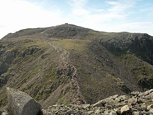
The top of Scafell Pike, and other peaks nearby, is covered with broken rock pieces. This is the highest example of a "summit boulder field" in England. Scientists think this field of boulders was partly caused by weathering. This is when rocks break down over time, for example, from frost action. Frost action happens when water freezes in cracks, expands, and breaks the rock.
There are also high-altitude streams, called gills, to the north of the summit. These flow into Lingmell Beck. These gills are special in Cumbria. They are also important for nature because many different kinds of plants and animals live there.
Visiting Scafell Pike
Scafell Pike is a very popular place for people who love to walk. You can freely explore Scafell and the hills around it. There are many paths for walking and routes for rock climbing.
Paths connect the summit to other important spots. These include Lingmell Col to the northwest, Mickledore to the southwest, and Esk Hause to the northeast. These paths then link up with many other routes. This means walkers can reach the mountain from many directions. Some popular starting points are Wasdale Head to the west, Seathwaite to the north, Langdale to the east, and Eskdale to the southwest.
The shortest way to climb Scafell Pike is from Wasdale Head. This spot is about 80 meters (260 feet) above sea level. There's a hotel for climbers there called the Wasdale Head Inn. It became famous in the Victorian period thanks to climbers like Owen Glynne Jones. The National Trust reported in 2014 that over 100,000 people climb Scafell Pike from Wasdale Head each year. Many of them are doing the National Three Peaks Challenge.
The Story Behind the Name
The name Scafell might come from an old Norse word, skalli fjall. This could mean "the fell with the shieling" (a small hut for shepherds) or "the fell with the bald summit." The name was first written down in 1578 as Skallfield. Another idea is that it comes from the Old Norse word "skagi," meaning a cape or headland. This would link it to places like Skaw in Shetland.
The name originally referred to Scafell, which is next to Scafell Pike. What we now call Scafell Pike, Ill Crag, and Broad Crag were once known together as the Pikes (meaning peaks) or the Pikes of Scawfell. From many angles, Scafell looks like the highest peak. So, the others were thought of as smaller parts of it.
The name Scawfell Pikes was generally accepted by 1830. Before this, England's highest mountain didn't have its own name. The Ordnance Survey first called it Sca-Fell Higher Top in the early 1800s. The new name, Scawfell Pikes, first appeared on an Ordnance Survey map in 1865.
The name used to be spelled Scawfell. This spelling sounds more like how local people say it. However, the spelling Scafell became more common after the Ordnance Survey started using it on their maps in 1865.
Amazing Views from the Top
When you reach the summit of Scafell Pike, you get incredible views! Because it's the highest point in England, you can see very far.
Summer Views
(Scroll left or right)
Winter Views
Mountains You Can See
On a clear day, you can see many other mountains from the top of Scafell Pike. These include:
- Dun Rig, 77 miles (124 km) away
- Binsey, 18 miles (29 km) away
- Turner Cleuch Law, 71 miles (114 km) away
- Dale Head, 5 miles (8 km) away
- Wisp Hill, 58 miles (93 km) away
- Skiddaw, 14 miles (23 km) away
- Roan Fell, 55 miles (89 km) away
- Knott, 17 miles (27 km) away
- Peel Fell, 63 miles (101 km) away
- Blencathra, 14 miles (23 km) away
- The Cheviot, 83 miles (134 km) away
- Cold Fell, 39 miles (63 km) away
- Howgill Fells, 29 miles (47 km) away
- Bow Fell, 2 miles (3 km) away
- Yorkshire Three Peaks, 36, 44 and 38 miles (58, 71 and 61 km) away
- Boulsworth Hill, 63 miles (101 km) away
- Pendle Hill, 55 miles (89 km) away
- Ward's Stone, 38 miles (61 km) away
- The Old Man of Coniston, 7 miles (11 km) away
- Winter Hill, 64 miles (103 km) away
- Snaefell, 52 miles (84 km) away
- Slieve Donard, 111 miles (179 km) away
- Slieve Croob, 112 miles (180 km) away
- Beneraird, 80 miles (130 km) away
- Merrick, 69 miles (111 km) away
- Pillar, 4 miles (6 km) away
- Cairnsmore of Carsphairn, 68 miles (109 km) away
- High Stile, 6 miles (10 km) away
- Criffel, 37 miles (60 km) away
- Grasmoor, 8 miles (13 km) away
- Great Gable, 2 miles (3 km) away
See also
 In Spanish: Scafell Pike para niños
 | Victor J. Glover |
 | Yvonne Cagle |
 | Jeanette Epps |
 | Bernard A. Harris Jr. |


