
Binsey facts for kids
Quick facts for kids Binsey |
|
|---|---|

Binsey from Longlands Fell to the east
|
|
| Highest point | |
| Elevation | 447 m (1,467 ft) |
| Prominence | 242 m (794 ft) |
| Parent peak | Knott |
| Listing | Marilyn, Wainwright |
| Geography | |

Binsey
Location in Lake District

Binsey
Location in Allerdale
|
|
| Location | Cumbria, England |
| Parent range | Lake District, Northern Fells |
| OS grid | NY225355 |
| Topo map | OS Landrangers 89, 90, Explorer OL4 |
Binsey is a hill located on the northern edge of the Lake District in Cumbria, England. It stands a bit separate from the other Lakeland hills. This makes it a fantastic spot to enjoy wide-open views!
From Binsey, you can look out over the Northern and North Western Fells of the Lake District. You can also see the flat coastal plain and, across the Solway Firth, even Scotland. On a very clear day, you might even spot Snaefell on the Isle of Man. Binsey is also the most northern hill on the famous list of 'Wainwrights'. These are hills described in guidebooks by Alfred Wainwright.
Contents
What Binsey Looks Like
Binsey sits on a low ridge of land. This ridge separates the areas where water flows into two different rivers: the River Ellen to the north and the River Derwent to the south. A small ridge connects Binsey to Great Cockup, which is part of the main group of Northern Fells.
Binsey has a rounded, dome-like shape. Even though it's not very tall, its shape makes it stand out. It looks more impressive than some other similar hills.
The hill's rounded shape is mostly even, except to the north-west. Here, a ridge goes down towards a flat area. This area holds the remains of an old Roman fort. Further along this ridge is St John's Hill, which has an old earthwork called 'The Battery' on top. The ridge then goes down to the village of Bothel.
Binsey also has another ridge that goes east. This ends at a neat hill called Latrigg. This isn't the same Latrigg that is near Keswick. Below this Latrigg is Over Water. This is a large lake that was made bigger in 1920 to provide drinking water for Wigton. Water from Over Water flows into the River Ellen. Another stream, called Humble Jumble Gill, also drains water from Binsey's northern side into the Ellen.
Most of Binsey is covered in grass and heather. There's only one noticeable rock outcrop, called West Crag. On the eastern side of the hill, there's a thin line of mixed trees. Another group of trees sits below West Crag.

The Top of Binsey
At the very top of Binsey, you'll find an ancient burial mound, called a tumulus. People have used stones from this mound to build several small, circular shelters to block the wind. There's also a newer pile of stones, called a cairn, on top of the mound. You'll also see a trig point, which is a pillar used for surveying.
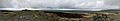
The famous guidebook writer Alfred Wainwright loved the view from Binsey. He said it was an "excellent station" to study the Northern Fells before exploring them. He called it a "viewpoint of outstanding merit." You can see very far from here. To the south, you might even see the Coniston Fells, which are almost 25 miles (40 km) away! To the north, you can clearly see the Solway Firth and the hills of Scotland.
On a very clear day, the furthest point you can see from Binsey is the top of Slieve Donard. This mountain is in Mourne, Northern Ireland, and is about 115 miles (185 km) away!
What Binsey is Made Of
Binsey is formed from volcanic rocks. These rocks include different types of lava, such as basaltic andesite, andesite, and rhyolitic lava. You can find several small, old quarries (places where rock was dug out) on the east and north sides of the hill.
How to Climb Binsey
There are a few ways to climb Binsey. One of the easiest ways starts from the south-east. You can park on the road between Binsey Lodge and Fell Side Farm. From there, you follow a track directly to the top.
Another way is to take a lane from the A591 road, just north of Bewaldeth. From the top of this lane, you can loop to the left and go behind an old pit. This will lead you to the track that goes across the summit. Alfred Wainwright also mentions a route from High Ireby.
Images for kids
-
A panorama from the summit of Binsey, November 2019
