
Snaefell facts for kids
Quick facts for kids Snaefell |
|
|---|---|
| Sniaull | |
 |
|
| Highest point | |
| Elevation | 2,037 ft (621 m) |
| Prominence | 2,037 ft (621 m) |
| Parent peak | none – HP Isle of Man |
| Listing | Marilyn, Hardy |
| Naming | |
| English translation | snow fell |
| Language of name | Icelandic |
| Geography | |

Snaefell
Location in Isle of Man
|
|
| Location | Isle of Man |
| OS grid | SC397881 |
| Topo map | OS Landranger 95 |
Snaefell is the tallest mountain on the Isle of Man. Its name comes from an old language and means "snow mountain." It stands about 620 meters (or 2,037 feet) above the sea. At the very top of Snaefell, you'll find a small railway station, a cafe, and some communication towers. It's the only peak on the island that is taller than 2,000 feet!
Contents
Amazing Views from Snaefell
People on the Isle of Man have a saying that on a clear day, you can see six "kingdoms" from the top of Snaefell. These include the Isle of Man, England, Ireland, Scotland, Wales, and even "Heaven." Some people add a seventh kingdom, which is the sea, or the kingdom of Manannán mac Lir, a sea god.
A special plaque at the top of the mountain helps you find different places. It shows how far away they are and in which direction.
- The Mull of Galloway in Scotland is about 31 miles (50 km) away.
- Scafell in England is about 51 miles (82 km) away.
- The Mourne Mountains in Northern Ireland are about 66 miles (106 km) away.
- The city of Liverpool in England is about 85 miles (137 km) away.
- Dublin in the Republic of Ireland is about 97 miles (156 km) away.
If the weather is very clear, you can see parts of all four countries of the United Kingdom from Snaefell. This includes the southern coast of Dumfries and Galloway in Scotland, the Lake District in England, the northern coast of Anglesey in Wales, and the Mourne Mountains in Northern Ireland. You might also see parts of County Louth in the Republic of Ireland.
How to Reach Snaefell's Summit
There are a few ways to get to the top of Snaefell.
Riding the Snaefell Mountain Railway
The Snaefell Mountain Railway is an electric tram that runs up the mountain. It usually operates from April to October. The tram ride is about 4 miles (6 km) long and starts from a town called Laxey. It's a fun way to see the views as you go up!
Walking Up Snaefell
The A18 Snaefell Mountain Road goes along the side of Snaefell. This road is also part of the famous Isle of Man TT Races course. Many walkers start their climb from a car park on this road, near the Bungalow railway station. This station is the last stop before the summit on the railway line.
From the Bungalow, there is a path that leads to the peak. The path is made of gravel, slate stones, grass, and rocks. As you get closer to the top, the path becomes steeper. You don't need special climbing gear, but you should be careful. The ground can be slippery, especially if it's wet. On a dry day, it takes about 45 minutes to walk to the summit.
At the very top, you will see a small concrete monument called an obelisk. It has a special marker inside that shows the exact highest point of the mountain. There is also a pile of rocks, called a cairn, with an information plaque on it.
Snaefell's Weather Conditions
Snaefell can experience very strong winds. In 1970, a weather station at the summit recorded a wind gust of 150 miles per hour (241 km/h). This was one of the strongest winds ever recorded in the British Isles. In 1966, a tall radio mast, which was 120 feet (37 meters) high, was damaged and blown down by hurricane-force winds.
Gallery
-
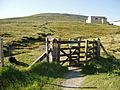
Footpath entry near Bungalow railway station typically used to climb Snaefell
-
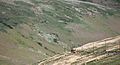
The Snaefell Mountain Railway on the ascent of Snaefell
-
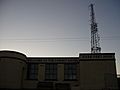
Defunct hotel (now cafe) near the summit
-
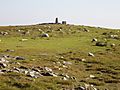
Top of Snaefell with geodetic marker and nearby cairn with plaque
-
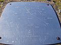
Plaque pointing out the directions of landmarks and their distances from the summit


See also
 In Spanish: Monte Snaefell para niños
