
Dumfries and Galloway facts for kids
Quick facts for kids
Dumfries and Galloway
Dumfries an Gallowa Dùn Phris is Gall-Ghaidhealaibh |
|||
|---|---|---|---|
|
|||
 |
|||
| Sovereign state | United Kingdom | ||
| Country | Scotland | ||
| Lieutenancy areas | Dumfries Stewartry of Kirkcudbright Wigtown |
||
| Admin HQ | County Buildings, English Street, Dumfries | ||
| Area | |||
| • Total | 2,481 sq mi (6,427 km2) | ||
| Area rank | Ranked 3rd | ||
| Population
(2020)
|
|||
| • Total | 148,790 | ||
| • Rank | Ranked 13th | ||
| • Density | 59.960/sq mi (23.1508/km2) | ||
| ONS code | S12000006 | ||
| ISO 3166 code | GB-DGY | ||

Dumfries and Galloway is one of Scotland's 32 main local government areas. It's located in the western part of the Southern Uplands, a hilly region.
This area shares borders with other parts of Scotland like East Ayrshire, South Ayrshire, South Lanarkshire, and the Scottish Borders. To the south, it meets the English county of Cumbria, the Solway Firth, and the Irish Sea. The North Channel is to its west.
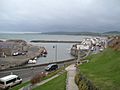
The biggest town and main office for the area is Dumfries. The second largest town is Stranraer, which is about 76 miles (122 km) west of Dumfries, right on the coast.
Dumfries and Galloway used to be three separate historic areas: Dumfriesshire, Kirkcudbrightshire, and Wigtownshire. The last two are often called Galloway. These three areas were joined together in 1975 to form one big region. In 1996, it became a single local authority, meaning it has its own council to manage the area.
Contents
History and Geography
A Look at the Past
The name "Dumfries and Galloway" has been used for a long time, even before the 19th century. By 1911, these three areas already shared a united legal system.
Where is it?


Dumfries and Galloway covers most of the western part of the Southern Uplands. It's also home to Scotland's most southerly point, called the Mull of Galloway, which is in the western part of the region.
Main Areas
The Dumfries and Galloway Council area is made up of several historic counties and smaller parts within them. From east to west, these are:
- Dumfriesshire County
- Kirkcudbrightshire County
- Stewartry (also known as Desnes)
- Wigtownshire County
- Machars (also known as Farines)
- Rhins of Galloway
Rivers and Valleys
The region has many rivers that flow south through the Southern Uplands. These rivers create natural paths for roads and railways that go north and south through the area. They also divide the hills into different ranges.
Some of the main river systems include:
- The River Cree valley, which has a road leading northwest from Newton Stewart.
- The Water of Ken and River Dee, which form a path through the hills called the Glenkens.
- The River Nith, which flows south to Dumfries. This valley is important for a main road and railway line.
- The River Annan, which, along with other waters, forms a key route into central Scotland from England.
- The River Esk, which flows into the Solway Firth.
Beautiful Scenic Areas
There are three special "National Scenic Areas" in this region, known for their amazing natural beauty:
- Nith Estuary: This area follows the River Nith as it flows into the Solway Firth. The town of Dumfries has a long history. It's famous as the place where Robert the Bruce had an important moment in 1306 before becoming King of Scotland. The famous poet Robert Burns also spent his last years here. You can visit Caerlaverock Castle, a wildfowl reserve, and Sweetheart Abbey. Criffel mountain offers great views.
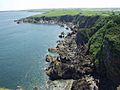
- East Stewartry Coast: This area covers the coastline with pretty villages like Auchencairn and Rockcliffe. You can also find Orchardton Tower here, and at low tide, you can walk to Hestan Isle and Rough Island.
- Fleet Valley: This area includes Fleet Bay, popular for holidays, and the town of Gatehouse of Fleet. You can visit Cardoness Castle here.
Getting Around


You can travel around Dumfries and Galloway by bus and train. Bus companies like Stagecoach Western operate here. For trains, you can use ScotRail, TransPennine Express, and Avanti West Coast.
There are seven active train stations in the region:
- Stranraer railway station
- Kirkconnel railway station
- Sanquhar railway station
- Dumfries railway station
- Annan railway station
- Gretna Green railway station
- Lockerbie railway station
Some railway lines were closed in the past, like the one from Dumfries to Stranraer Harbour. This used to connect London to ferries going to Northern Ireland.
Buses connect the main towns, and express services link the region to bigger cities like Glasgow and Edinburgh.
Dumfries and Galloway has two ports in the west, both in the village of Cairnryan. From here, you can take ferries to Northern Ireland with companies like Stena Line and P&O Irish Sea.
There are no large commercial airports in the region. The closest ones are Glasgow Prestwick Airport and Carlisle Lake District Airport.
The town of Lockerbie was the scene of a tragic event on 21 December 1988.
The main roads in and out of the region are:
Emergency Services

For safety, Police Scotland is the police force for the entire region. The Scottish Fire and Rescue Service helps with fires and other emergencies. The Coastguard, Lifeboats, and mountain rescue teams also provide emergency help across Dumfries and Galloway.
Nith Inshore Rescue is a special lifeboat service based at Glencaple. It helps with water rescues on the River Nith and other nearby waters.
NHS Dumfries and Galloway provides healthcare. The two main hospitals are the Dumfries and Galloway Royal Infirmary in Dumfries and Galloway Community Hospital in Stranraer.
Education
Dumfries & Galloway Council provides education for children from nursery to secondary school.
Alternative Schools
- Kilquhanity School
Secondary Schools

- Annan Academy
- Castle Douglas High School
- Dalbeattie High School
- Douglas Ewart High School, Newton Stewart
- Dalry Secondary School
- Dumfries Academy
- Kirkcudbright Academy
- Langholm Academy
- Lockerbie Academy
- Maxwelltown High School, Dumfries
- Moffat Academy
- Sanquhar Academy
- St Joseph's College
- Stranraer Academy
- Wallace Hall, Thornhill
Culture
Amazing Wildlife

This region is a special place for rare amphibians like the Natterjack toad and the Great crested newt. There are also several RSPB Nature Reserves (places to protect birds and wildlife) at the Mull of Galloway, Wood of Cree, Ken Dee Marshes, and Mereshead.
Fun Outdoor Activities
If you love being outdoors, Dumfries and Galloway is a great place!
- There are five 7Stanes mountain biking centers at Dalbeattie, Mabie, Ae, Glentrool, and Kirroughtree.
- The Sustrans Route 7, a long-distance cycle path, also goes through the region.
- You can enjoy excellent hill walking in the Moffat Hills, Lowther Hills, Carsphairn and Scaur Hills, and Galloway Hills.
- The Southern Upland Way, a long walk from coast to coast, passes through here.
- The 53-mile long Annandale Way travels from the Solway Firth into the Moffat hills.
- You can go sailing on Castle Loch at Lochmaben and on Loch Ken. Loch Ken also offers waterskiing and wakeboarding.
- The Solway Firth coastline is perfect for fishing, camping, walking, and sailing.
Arts and Media
Dumfries and Galloway is known for its lively arts and culture scene.
- Major festivals include the Dumfries & Galloway Arts Festival and Spring Fling Open Studios.
- Other popular events are the Big Burns Supper in Dumfries and the Wigtown Book Festival in Wigtown, which is Scotland's national book town.
For TV, the area is covered by BBC Scotland and ITV Border. Radio stations include BBC Radio Scotland and Greatest Hits Radio Dumfries & Galloway.
Local newspapers serving the area are:
- Dumfries and Galloway Standard
- Annandale Herald
- Annandale Observer
- Dumfries Courier
- Eskdale and Liddesdale Advertiser
- Galloway Gazette
- Galloway News
- Moffat News
- Stranraer and Wigtownshire Free Press
Towns and Villages
Here are the largest towns and villages by population:
| Settlement | Population (2020) |
|---|---|
| Dumfries | 33470 |
| Stranraer | 10110 |
| Annan | 8760 |
| Locharbriggs | 5610 |
| Lockerbie | 4190 |
| Dalbeattie | 4160 |
| Newton Stewart | 4030 |
| Castle Douglas | 4000 |
| Kirkcudbright | 3350 |
| Gretna | 3110 |
Main settlements are shown in bold text.
- Ae, Airieland, Airds of Kells, Annan, Anwoth, Ardwell
- Beattock, Beeswing, Borgue, Brydekirk
- Caerlaverock, Cairngaan, Cairnryan, Cargenbridge, Carsphairn, Castle Douglas, Castle Kennedy, Clarencefield, Corsock, Creetown
- Dalbeattie, Dalton, Dornock, Drumlanrig, Drummore, Dumfries, Dundrennan, Dunscore
- Eastriggs, Ecclefechan, Eskdalemuir
- Garlieston, Gatehouse of Fleet, Glenluce, Gretna Green, Gretna
- Haugh of Urr, Hoddom
- Isle of Whithorn
- Johnsfield, Johnstonebridge
- Keir, Kelloholm, Kippford, Kirkbean, Kirkcolm, Kirkcowan Kirkcudbright, Kirkconnel, Kirkinner, Kirkpatrick Durham
- Langholm, Leswalt, Locharbriggs, Lochmaben, Lockerbie
- Middleshaw, Millhousebridge, Mochrum, Moffat, Moniaive, Muirhead, Mull of Galloway
- New Abbey, New Galloway, New Luce, Newton Stewart, Newton Wamphray
- Palnackie, Parkgate, Parton, Penpont, Portpatrick, Port William
- Ringford, Robgill Tower, Ruthwell
- Sandhead, Sanquhar, Sorbie, St John's Town of Dalry, Stoneykirk, Stranraer
- Templand, Terregles, Thornhill, Twynholm
- Unthank
- Wanlockhead, Whithorn, Wigtown
Places to Visit
Here are some interesting places you can visit in Dumfries and Galloway:
- Annandale distillery - learn about Scotch Whisky
- Bladnoch Distillery & Visitor Centre - another place to learn about Scotch Whisky
- Caerlaverock Castle – a historic castle
- Caerlaverock NNR (national nature reserve) - a special place for nature
- WWT Caerlaverock – a reserve for wild birds
- Cardoness Castle
- Castle of St John, Stranraer
- Corsewall Lighthouse
- Drumlanrig Castle
- HM Factory, Gretna, Eastriggs – a historic factory site from World War I
- Galloway Forest Park, Forestry and Land Scotland – a large forest park
- Galloway Hydro Electric Scheme – a power station using water
- Glenlair – home of a famous scientist, James Clerk Maxwell
- Glenluce Abbey
- Hallhill Covenanter Martyrs Memorial
- Isle of Whithorn Castle
- Kenmure Castle
- Loch Ken
- MacLellan's Castle, Kirkcudbright
- Motte of Urr
- Mull of Galloway – Scotland's most southerly point with a lighthouse
- Ruthwell Cross – an ancient stone cross
- Samye Ling Tibetan Monastery – a peaceful monastery
- Southern Upland Way – a long walking path
- Sweetheart Abbey, New Abbey – a beautiful old abbey
- Threave Castle
How the Area is Governed
| Dumfries and Galloway | |
|---|---|
 |
|
| Leadership | |
|
Dawn Roberts
Since July 2022 |
|
| Structure | |
| Seats | 43 councillors |
 |
|
|
Political groups
|
|
| Elections | |
| Single transferable vote | |
|
Last election
|
6 May 2022 |
|
Next election
|
2027 |
| Meeting place | |
.jpg) |
|
| Council Offices, 113 English Street, Dumfries, DG1 2DD | |
The Dumfries and Galloway Council is in charge of running the local area.
How it's Been Managed Over Time
Before 1975, the area was split into three separate counties: Dumfriesshire, Kirkcudbrightshire, and Wigtownshire. Each county had its own council to manage things.
In 1975, these three counties were joined together to form one big region called Dumfries and Galloway. This region was then divided into four smaller areas called districts.
Later, in 1996, these four districts were removed, and the Dumfries and Galloway Council took over all the responsibilities. The council still uses these old district areas for some of its committees.
The main office for the council is at the Council Offices in Dumfries.
Leaders of the Council
The council has a leader who helps guide its work. Here are some of the leaders since 2007:
| Councillor | Party | From | To | Notes | |
|---|---|---|---|---|---|
| Ivor Hyslop | Conservative | 15 May 2007 | 1 Oct 2013 | ||
| Ronnie Nicholson | Labour | 1 Oct 2013 | 23 May 2017 | ||
| Elaine Murray | Labour | 23 May 2017 | 5 May 2022 | ||
| Stephen Thompson | SNP | 24 May 2022 | 3 Feb 2023 | They were co-leaders, sharing the role. | |
| Linda Dorward | Labour | ||||
| Stephen Thompson | SNP | 3 Feb 2023 | 28 Feb 2023 | ||
| Gail Macgregor | Conservative | 7 Mar 2023 | |||
Elections
Elections for the council are held every five years. People vote using a system called "single transferable vote," which helps make sure the results are fair.
Here's how the different political groups have done in recent elections:
| Year | Seats | Conservative | SNP | Labour | Liberal Democrats | Independent | Notes |
|---|---|---|---|---|---|---|---|
| 1995 | 70 | 2 | 9 | 21 | 10 | 28 | |
| 1999 | 47 | 8 | 5 | 13 | 6 | 15 | New voting areas. |
| 2003 | 47 | 11 | 5 | 14 | 5 | 12 | |
| 2007 | 47 | 18 | 10 | 14 | 3 | 2 | New voting areas. |
| 2012 | 47 | 14 | 10 | 15 | 1 | 7 | |
| 2017 | 43 | 16 | 11 | 11 | 1 | 4 | New voting areas. |
| 2022 | 43 | 16 | 11 | 9 | 1 | 6 | |
Wards
.svg)
The council area is divided into 12 "wards," which are like local voting districts. These wards elect 43 councillors to represent the people.
| Ward Number | Ward Name | Location | Seats |
|---|---|---|---|
| 1 | Stranraer and the Rhins |  |
4 |
| 2 | Mid Galloway and Wigtown West |  |
4 |
| 3 | Dee and Glenkens |  |
3 |
| 4 | Castle Douglas and Crocketford |  |
3 |
| 5 | Abbey |  |
3 |
| 6 | North West Dumfries |  |
4 |
| 7 | Mid and Upper Nithsdale |  |
3 |
| 8 | Lochar |  |
4 |
| 9 | Nith |  |
4 |
| 10 | Annandale South |  |
4 |
| 11 | Annandale North |  |
4 |
| 12 | Annandale East and Eskdale |  |
3 |
Images for kids
-
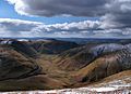
Dalveen Pass from Comb Head summit, near Thornhill, Dumfries and Galloway, Scotland.
-
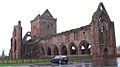
Sweetheart Abbey, Dumfries and Galloway (Scotland)
-
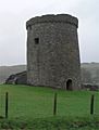
Orchardton Tower, Dumfries and Galloway, Scotland
-
Caerlaverock National Nature Reserve. View across the Nith Estuary, close to the Solway Firth, Dumfries & Galloway.
-
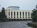
Tongland Power station.
-
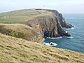
Mull of Galloway headland.
-
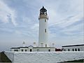
Mull of Galloway Lighthouse.
-
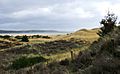
A Machars beach.
-
Machars Coastline looking south from Cruggleton Castle.
-
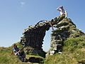
The remains of Cruggleton Castle.
-
The Machars, as viewed from Torrs Warren with Luce Bay standing between.
-
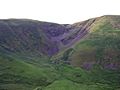
The Devil's Beef Tub.
-
Port William harbour.
-
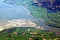
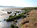
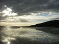
River Nith Estuary.


See also
 In Spanish: Dumfries and Galloway para niños
