North Channel (Great Britain and Ireland) facts for kids
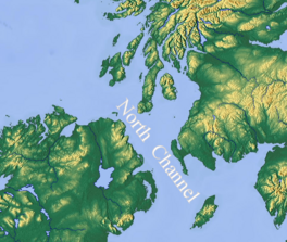
The North Channel is a narrow stretch of sea, also called a strait. It lies between the northeastern part of Ireland and the southwestern part of Scotland. In Irish and Scottish Gaelic, it's known as Sruth na Maoile. In Scots, people sometimes call it the Sheuch.
Quick facts for kids North Channel (Great Britain and Ireland) |
|
|---|---|
 |
|
| Type | Strait |
| Native name | Sruth na Maoile (Scottish Gaelic) |
| Part of | Irish Sea |
| Ocean/sea sources | Atlantic Ocean |
| Surface area | 160,367 hectares (396,280 acres) |
| Frozen | No |
| Trenches | Beaufort's Dyke |
This important channel connects the Irish Sea to the vast Atlantic Ocean. It starts north of the Isle of Man and flows northwest. A very deep area within the channel is called Beaufort's Dyke. Its deepest point is about 312 meters (1,024 feet) down.
Contents
Exploring the North Channel's Geography

The North Channel is a key waterway. It links the Irish Sea with the Atlantic Ocean. It is also part of a larger marine area. This area is known as the "Inner Seas off the West Coast of Scotland."
The Narrow Straits of Moyle
The narrowest part of the North Channel has a special name: the Straits of Moyle. In Irish and Scottish Gaelic, it's Sruth na Maoile. This section is found between County Antrim in Northern Ireland and the Mull of Kintyre in Scotland. At its narrowest, it's only about 19 kilometers (12 miles) wide. On a clear day, you can often see across it!
The name "Straits of Moyle" is famous in Celtic mythology. It is linked to the ancient Irish legend of the Children of Lir. This story tells of children turned into swans. The local government area in Northern Ireland, Moyle District Council, also took its name from these straits.
Historical Names and Events
Long ago, in the 1800s, people sometimes called this strait the "Irish Channel." Another suggested name was St. Patrick's Channel. However, this name was not officially adopted.
The North Channel has seen many historical events. In the past, during wars, it was a place where ships called privateers operated. These ships would try to capture merchant vessels. In 1778, during the American Revolutionary War, a naval battle took place here. It was between an American ship, the USS Ranger, and a British ship, HMS Drake. Today, many ferry services regularly cross the channel. In 1953, a sad event occurred when the ferry MV Princess Victoria sank in the channel.
Amazing Swims Across the Channel
Crossing the North Channel is a huge challenge for swimmers. The Irish Long Distance Swimming Association (ILDSA) helps record these amazing feats. The distance between Northern Ireland and the Mull of Galloway is about 35 kilometers (22 miles).
The first person to swim across the North Channel was Tom Blower in 1947. This was a truly incredible achievement! Later, in 2015, a team of six swimmers completed the first two-way crossing. This means they swam across and back again.
The North Channel is part of a special group of swims. It is one of the "Ocean's Seven" challenges. These are seven very long open-water swims around the world. They are considered the marathon swimming equivalent of climbing the Seven Summits, the highest mountains on each continent.
Ideas for Connecting Scotland and Ireland
For many years, people have discussed building a permanent link across the North Channel. This could be a bridge or a tunnel. The idea is to connect Northern Ireland more closely with the rest of the United Kingdom.
Past and Present Proposals
In the Victorian era, engineers first thought about building a rail tunnel. This would have connected Stranraer in Scotland to Belfast in Northern Ireland. More recently, in 2007, a study suggested a 34-kilometer (21-mile) long rail bridge or tunnel. It was estimated to cost around £3.5 billion.
In February 2020, the British government began looking into the idea of a bridge. They wanted to see if it was possible to build one between Scotland and Northern Ireland.
Possible Routes and Challenges
One possible route for a bridge or tunnel is between Campbeltown in Scotland and Ballycastle, County Antrim in Northern Ireland. This route is shorter for sailing. Another route, used by current ferries, is between Portpatrick/Stranraer and Larne. This route has a coast-to-coast distance of about 45 kilometers (28 miles).
However, building a bridge or tunnel on this route would be very challenging. It would need to cross Beaufort's Dyke. This is a very deep trench, about 200 to 300 meters (656 to 984 feet) deep. Old materials were placed at the bottom of this trench long ago, making construction difficult.
The former First Minister of Scotland, Nicola Sturgeon, once commented on the idea. She said that while she was open to it, such a project would be extremely expensive. She suggested that the money might be better spent on other important priorities.
See also
 In Spanish: Canal del Norte (islas británicas) para niños
- Seas west of Scotland
- St George's Channel
- Sinking of the ferry MV Princess Victoria in 1953
 | Emma Amos |
 | Edward Mitchell Bannister |
 | Larry D. Alexander |
 | Ernie Barnes |

