
Mull of Kintyre facts for kids
Quick facts for kids Mull of Kintyre
|
|
|---|---|
 Mull of Kintyre Lighthouse |
|

Mull of Kintyre
|
|
| OS grid reference | NR5908 |
| Civil parish |
|
| Council area | |
| Lieutenancy area | |
| Country | Scotland |
| Sovereign state | United Kingdom |
| Post town | Campbeltown |
| Postcode district | PA28 |
| Dialling code | 01586 |
| Police | Strathclyde |
| Fire | Strathclyde |
| Ambulance | Scottish |
| EU Parliament | Scotland |
| UK Parliament |
|
| Scottish Parliament | |
The Mull of Kintyre is the very southwestern tip of the Kintyre Peninsula in southwest Scotland. It's a famous spot where you can often see the Antrim coast of Northern Ireland on a clear day.
A historic lighthouse, one of the first ever built in Scotland, stands here. It helps guide ships safely through the North Channel. This area also became well-known because of the 1977 hit song "Mull of Kintyre" by Paul McCartney's band, Wings. Paul McCartney used to live in Kintyre.
Contents
What's in the Name?
The name 'Mull of Kintyre' comes from the Gaelic words Maol Chinn Tìre. This means "The rounded [or bare] headland of Kintyre."
The word chinn comes from ceann, meaning head. The word tìre comes from tìr, meaning land or country.
The word mull is often used in southwest Scotland for headlands or points of land sticking out into the sea. It means a piece of land that is "bald" or "bare," usually without many trees.
Where is the Mull of Kintyre?
The Mull is at the very end of the Kintyre peninsula. It is about 10 miles (16 km) from Campbeltown in Argyll and Bute, Western Scotland.
You can reach it by driving about 8 miles (13 km) past Southend village. The road is a single-track road, meaning it's narrow and only wide enough for one car at a time in most places.
From the Mull, you can clearly see Ailsa Craig and the County Antrim coast of Ulster. Rathlin Island is also easy to spot. On very clear days, you might even see Malin Head in County Donegal in western Ulster. The Ayrshire coast, on the other side of Ailsa Craig, can also be seen.
The Straits of Moyle are part of the North Channel. They connect the Irish Sea to the Atlantic Ocean. Strong currents here make it very hard for small boats or swimmers. The closest point of mainland Ulster is about 12 miles (19 km) from the Mull.
A Look Back in Time
The Mull of Kintyre has been an important place for a long time. It is thought that early humans used it as a "land bridge." They might have traveled this way from continental Europe to Ireland through Britain.
Later, the Scotti people used this route. They traveled from Ireland to create the kingdom of Dál Riata in what is now Argyll.
Air Accidents
The Mull of Kintyre has steep cliffs and hills rising from the sea. It also often has thick sea mists. These conditions have made the area dangerous for planes. Many aircraft have crashed here over the years. You can still find parts of some crashed planes in the area.
One well-known air accident was the RAF Chinook helicopter crash on June 2, 1994.
Shipwrecks
On June 13, 1858, a steamship called the SS New York was wrecked. This happened at the south end of the Mull of Kintyre.
The Lighthouse
The Mull of Kintyre Lighthouse stands proudly at the tip of the Mull. It was the second lighthouse ever built in Scotland. It plays a vital role in guiding ships safely through the busy waters.
Images for kids
-
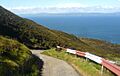
The Mull of Kintyre in the front, with Northern Ireland in the distance.
-
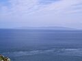
The Mull of Kintyre in the distance, seen from Torr Head, Northern Ireland.


See also
 In Spanish: Mull of Kintyre para niños
