
Ailsa Craig facts for kids
| Gaelic name | Creag Ealasaid |
|---|---|
| Meaning of name | Elizabeth's rock or Fairy rock |
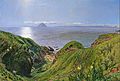
 Ailsa Craig from the southeast |
|
| OS grid reference | NX019997 |
| Coordinates | 55°15′N 5°07′W / 55.25°N 5.11°W |
| Physical geography | |
| Island group | Firth of Clyde |
| Area | 99 hectares (240 acres) |
| Area rank | 150= |
| Highest elevation | 338 m (1,109 ft) (a Marilyn) |
| Administration | |
| Sovereign state | United Kingdom |
| Country | Scotland |
| Council area | South Ayrshire |
| Demographics | |
| Population | 0 |
Ailsa Craig is a small island located in the Firth of Clyde, off the west coast of Scotland. It is about 16 kilometres (10 miles) west of the mainland town of Girvan. This island is famous for its special "blue hone" granite, which has been used for a long time to make curling stones.
Even though no one lives on Ailsa Craig today, it has a rich history. It was once a safe place for Catholics during the Scottish Reformation in the 1500s. Now, it is a protected home for many birds, especially gannets and puffins. People sometimes call it "Paddy's Milestone" because it's about halfway on the sea journey between Belfast and Glasgow.
Contents
What Does Ailsa Craig Mean?
The name "Ailsa Craig" comes from the Gaelic words Aillse Creag. This means "fairy rock." Another Gaelic name for the island is Creag Ealasaid, which means "Elizabeth's rock."
Because it's such a noticeable landmark, the island has several other names:
- A' Chreag: "the rock"
- Creag Alasdair: "Alasdair's rock"
- Ealasaid a' Chuain: "Elizabeth of the ocean"
Island Landmarks
Many places on the island have Gaelic names. For example:
- Craigna'an means "cliff of birds."
- Trammins means "place of Elder trees."
- Garryloo means "rough hill."
- Ashydoo means "black hill."
Island Features and Geology

Ailsa Craig is about 4 km (2.5 mi) around. It rises to a height of 340 m (1,120 ft). The island is part of the South Ayrshire area in Scotland.
The island is made from a very hard type of rock called microgranite. This rock formed a long time ago, during a period called the Palaeogene era. Because the microgranite is so hard, it has resisted erosion much better than the softer rocks around it. This is why Ailsa Craig stands out so much.
The special rock from Ailsa Craig is known for being very tough. This makes it perfect for making curling stones, which need to be strong and resistant to damage.
Who Owns Ailsa Craig?
The island has a fresh-water spring but no modern services like electricity or gas. Most of the island belongs to The 9th Marquess of Ailsa. However, the RSPB leases the island until 2050 to protect its wildlife.
There are a few buildings left on the island:
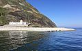
- The Ailsa Craig Lighthouse on the east coast.
- The ruins of a towerhouse built in the 1500s.
- The old quarry manager's house, used by the RSPB.
Fishermen have used the island for hundreds of years. They would even sleep under sails on the beach.
Ailsa Craig's Past


In 1590, pirates were causing trouble for ships in the Clyde. They were said to be hiding around Ailsa Craig. In 1831, the Earl of Cassilis became the first Marquess of Ailsa, taking his title from the island.
Ailsa Castle
On the east side of the island are the ruins of a 3-story castle. It is about 12-metre (39 ft) high. The Clan Hamilton family built it in the late 1500s. They wanted to protect the island from King Philip II of Spain. The castle was also used as a prison in the 1700s and 1800s.
A Haven for Catholics
Ailsa Craig became a safe place for Roman Catholics during the Scottish Reformation. In 1597, a Catholic supporter named Hugh Barclay of Ladyland took over the island. He planned to use it as a safe spot for Catholics to practice their faith. He also wanted it to be a supply point for a Spanish invasion. This invasion aimed to bring back the Catholic faith in Scotland.
However, a Protestant minister named Andrew Knox discovered Hugh's plans. Hugh Barclay then drowned, either by accident or on purpose, while trying to escape.
Smuggling Stories
There is a cave on the island named after a supposed smuggler called MacNall. When the cave was being cleaned many years ago, two stone coffins were found. They both contained human bones. It's possible one of them was MacNall himself. Ailsa Craig would have been a good place to hide illegal goods temporarily.
Lighthouse and Old Railways
The Ailsa Craig Lighthouse was built between 1883 and 1886. It is owned by the Northern Lighthouse Board. The lighthouse became automated in 1990. Since then, no one has lived on the island. It now uses solar power.
Two large foghorns were built in 1866. They were powered by compressed air from the lighthouse. These foghorns were stopped in 1966.

Ailsa Craig also had two separate railway systems. One was built in 1886. It carried coal, oil, and supplies to the lighthouse. The other railway was built in 1909. It moved rock from the quarries to the pier. This rock was used for roads.

The railway for the quarry was mostly pulled by horses. Wagons carried large granite blocks to a stone crusher. After crushing, the different sizes of stone were taken to the pier. From there, they were shipped to the mainland. The company that ran this quarry closed in 1928. You can still see parts of the old railway line today.
Curling Stones from Ailsa Craig
Since the mid-1800s, the island has been a source of a special type of granite called "blue hone." This granite is used to make stones for the sport of curling. About 60-70% of all curling stones used worldwide are made from Ailsa Craig granite. It is one of only two places in the world where curling stone granite comes from.
"Blue Hone" granite is very good for curling stones. It does not absorb much water. This stops the stone from breaking down when water freezes and thaws.
Kays of Scotland has been making curling stones since 1851. They have the special right to use Ailsa Craig granite. The last time granite was taken from the island was in 2013. Enough was collected to make stones for many years.
Wildlife on the Island
Ailsa Craig is now a very important bird sanctuary. The RSPB manages it. Huge numbers of gannets build their nests here.

Other animals found on the island include slowworms. In the past, there were also rabbits and goats. Pigs were even raised there for food.
Sadly, rats were brought to the island, probably from shipwrecks. They caused a lot of harm to the nesting birds. Puffins, for example, almost disappeared from the island. However, in 1991, a big effort was made to get rid of the rats. This was a success! Now, puffins are returning and raising their young on Ailsa Craig again. This has helped many other plants and animals on the island too.
There is a small freshwater lake on the island called Garry Loch. It is located high up, above Ailsa Castle.
Images for kids
-
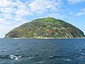
The eastern coast photographed from HMS Campbeltown.
-
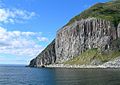
Columnar rock formations on the south-west side of the island.
-
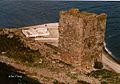
Lighthouse seen from the 16th century tower.
-
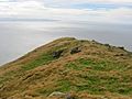
Summit ridge (338 m) across the Firth of Clyde.
-
Ailsa Craig by William Bell Scott, oil on canvas (1860)
-
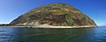
Ailsa Craig from the west
-
Lighthouse with seals


See also
 In Spanish: Ailsa Craig para niños
