
County Antrim facts for kids
Quick facts for kids
County Antrim
|
||
|---|---|---|
|
||
| Nickname(s):
The Glens County
|
||
| Motto(s): | ||
 |
||
| Country | United Kingdom | |
| Region | Northern Ireland | |
| Province | Ulster | |
| Established | c. 1400 | |
| County town | Antrim | |
| Area | ||
| • Total | 1,192 sq mi (3,086 km2) | |
| Area rank | 9th | |
| Highest elevation
(Trostan)
|
1,808 ft (551 m) | |
| Population
(2021)
|
651,321 | |
| • Rank | 2nd | |
| Time zone | UTC±0 (GMT) | |
| • Summer (DST) | UTC+1 (BST) | |
| Postcode area | ||
| Website | Discover Northern Ireland / Antrim | |
| Contae Aontroma is the Irish name; Coontie Antrìm, Countie Antrim, Coontie Anthrim and Coonty Entrim are Ulster-Scots names. | ||

County Antrim is one of the six counties in Northern Ireland. It's named after the town of Antrim. This county is part of the historic province of Ulster. It sits on the north-east side of Lough Neagh, a large lake.
County Antrim covers an area of about 3,086 square kilometers (1,192 square miles). In 2021, its population was 651,321 people. This makes it the most populated county in Northern Ireland. It's also the second most populated county on the entire island of Ireland.
This county is famous for its beautiful places. The Glens of Antrim have wild, rugged landscapes. The Giant's Causeway is a unique natural wonder and a World Heritage Site. You can also find the town of Bushmills, known for making whiskey. Portrush is a popular spot for holidays by the sea. Most of Belfast, the capital city of Northern Ireland, is in County Antrim.
Contents
Exploring County Antrim's Geography
County Antrim has many hills, especially in the east. The highest point is Trostan, standing at 550 meters (1,804 feet) tall. The hills slope gently on the inside, but on the northern coast, they drop sharply into cliffs. This creates some of the most stunning coastal views in the world.


The most famous cliffs are made of tall, upright rock columns. You can see these at Fair Head and the amazing Giant's Causeway. Along the eastern coast, the hills rise quickly but not as steeply. There are several popular seaside towns here, like Portrush, Ballycastle, Cushendun, Larne, and Whitehead.
The only large island is Rathlin Island, located off the coast near Ballycastle. It's about 11 kilometers (7 miles) long. The Islandmagee peninsula separates Larne Lough from the North Channel.
The areas around the Bann and Lagan rivers, and the shores of Lough Neagh, are very fertile. These rivers are important for fishing, especially for salmon and eels. The town of Toome is a center for these fisheries.
Getting Around County Antrim
County Antrim has good connections by air, rail, and sea.
Air Travel
Belfast International Airport is Northern Ireland's main airport. It's located in County Antrim, near Aldergrove. This airport has flights to Great Britain, Europe, and North America.
Another airport, George Best Belfast City Airport, is just east of Belfast city centre. It was named after the famous footballer George Best.
Train Routes

Translink Northern Ireland Railways operates several important train lines. There's a main line connecting Belfast, Antrim, Ballymena, Coleraine, and Derry. Other lines go from Belfast to Carrickfergus and Larne, and from Coleraine to Portrush.
Sea Ports
County Antrim is home to two of Northern Ireland's main ports: Larne and Belfast.
Ferries sail from Larne Harbour to places like Cairnryan in Scotland.
The Port of Belfast is the biggest port in Northern Ireland. It handles about two-thirds of Northern Ireland's sea trade. Over 6,000 ships visit the port each year.
People and Communities in Antrim
County Antrim is the most populated county in Northern Ireland. In 2021, its population was 651,321 people.
Different Backgrounds
County Antrim is a diverse place with people from many different backgrounds. The 2021 census showed that about 95.74% of the population is White. There are also significant Asian and Black communities.
Many people in County Antrim were born in Northern Ireland (about 86.89%). Others come from different parts of the United Kingdom like England and Scotland, or from the Republic of Ireland. There are also people who have moved to Antrim from countries across Europe, Asia, and Africa.
Community and Beliefs
County Antrim has a mix of community backgrounds and beliefs. The 2021 census showed that about 47.0% of people identify with a Protestant and Other Christian background. About 40.1% identify as Catholic. Around 10.8% said they had no religion, and 2.1% belonged to other faiths. This shows the rich variety of people living in the county.
National Identity
People in County Antrim identify with different national identities. In 2021, about 35.45% identified as British only, 25.71% as Irish only, and 18.71% as Northern Irish only. Many people also have a mix of these identities, like British and Northern Irish.
Irish Language in Antrim
The Irish language is taught and spoken in County Antrim. In 2009–2010, over 1,800 students attended Irish language primary schools, called Gaelscoileanna. There is also one Irish language secondary school, a Gaelcholáiste.
How County Antrim is Governed
From 1899 to 1973, County Antrim was managed by the Antrim County Council. The traditional main town of the county is Antrim. Later, Ballymena became the center for county government.
Since 1973, Northern Ireland has been divided into smaller areas called districts. County Antrim is now part of several of these districts:
- Antrim and Newtownabbey
- Belfast
- Causeway Coast and Glens
- Mid and East Antrim
- Lisburn and Castlereagh
- Armagh City, Banbridge and Craigavon
The county also contains parts or all of several areas represented in the Parliament of the United Kingdom.
Towns and Villages in Antrim
County Antrim is home to two cities and many towns and villages.
Cities
Large Towns
Small Towns

- Ballycastle
- Ballyclare
- Ballymoney
- Greenisland
- Jordanstown
- Portrush
- Randalstown
Villages

- Bushmills
- Carnlough
- Cushendall
- Glenavy
- Portglenone
- Templepatrick
- And many more smaller villages and hamlets.
History of County Antrim
County Antrim has a long and interesting history. It was first settled by Mesolithic hunter-gatherers, who lived there before the Celtic people arrived. The names of the local areas, called townlands, are all from Celtic languages.
In ancient times, a Celtic group called the Darini lived in Antrim. Later, parts of the county were ruled by different kingdoms, including Ulidia and Dál Riada. Between the 8th and 11th centuries, Vikings often raided the Antrim coast.
In the late 12th century, Anglo-Norman invaders took control, making Antrim part of the Earldom of Ulster. However, local Gaelic power grew again. By the late Middle Ages, Antrim was split into three main areas: Clandeboye, the Glynnes, and the Route.
During the 16th century, many Scottish people settled in Antrim. In 1588, the Spanish ship La Girona from the Spanish Armada in Ireland was wrecked off the Antrim coast, leading to a great loss of life.
In 1689, during the Williamite War in Ireland, County Antrim was a place of strong resistance against James II. Later that year, a large army from England landed in Belfast Lough and successfully took Carrickfergus.
Old Buildings and Sites


County Antrim has many old structures, including ancient burial mounds (cairns), forts, and remains of churches and castles.
There are three tall, round towers in the county: one in Antrim town, one in Armoy, and one on Ram's Island in Lough Neagh. Only the one in Antrim is still complete. You can also see parts of old churches at places like Bonamargy and Kells.
Carrickfergus Castle, built by the Normans, is one of the best-preserved medieval castles in Ireland. Other old castle ruins include Shane's, Glenarm, and Dunluce Castle, which is famous for being built on a rocky cliff.
The amazing rock formations of the Giant's Causeway are a UNESCO World Heritage Site.
Saint Patrick's Connection
Slemish mountain, about 8 kilometers (5 miles) east of Ballymena, is an important place in the story of Saint Patrick. Tradition says that Saint Patrick was a slave near Slemish for seven years before he managed to escape.
Linen Industry
Making linen used to be a very important industry in County Antrim. Ireland produced a lot of flax, which is used to make linen. In the late 1700s, cotton spinning also became popular in Belfast. By 1800, more than 27,000 people worked in this industry near Belfast.
Famous People from Antrim
Many notable people have come from County Antrim:
- Joey Dunlop (1952–2000), a five-time World Motorcycle Champion from Ballymoney.
- James Nesbitt (b.1965), a well-known actor from Broughshane.
- Liam Neeson (b.1952), a famous actor from Ballymena.
- Tony McCoy (b.1974), a top jockey from Moneyglass.
- George Macartney, 1st Earl Macartney (1737–1806), the first British Ambassador to China, from Ballymoney.
Nature and Wildlife
County Antrim is home to various plants and animals. Many types of seaweed grow along its coast. In its freshwater areas, you can find different kinds of algae, which are tiny plant-like organisms.
Sports in Antrim
Sports are a big part of life in County Antrim. The county has many sports clubs and teams, especially in Gaelic games like Gaelic football and hurling.
See also
 In Spanish: Condado de Antrim (Irlanda del Norte) para niños
- Abbeys and priories in Northern Ireland (County Antrim)
- List of townlands in County Antrim
- List of civil parishes of County Antrim
Images for kids
-
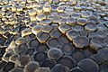
Columnar basalt at Giant's Causeway
.JPG)
