Larne facts for kids
Quick facts for kids Larne
|
|
|---|---|
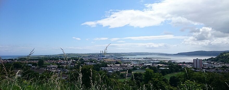
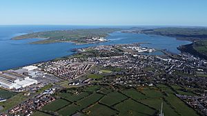 2020 view looking south-east towards Larne Harbour, Islandmagee, and down the length of Larne Lough |
|
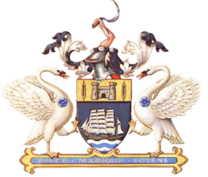 Larne Coat of Arms |
|
| Population | 18,853 (2021 census) |
| Irish grid reference | D4102 |
| • Belfast | 30 km (19 mi) |
| District |
|
| County | |
| Country | Northern Ireland |
| Sovereign state | United Kingdom |
| Post town | LARNE |
| Postcode district | BT40 |
| Dialling code | 028 |
| Police | Northern Ireland |
| Fire | Northern Ireland |
| Ambulance | Northern Ireland |
| EU Parliament | Northern Ireland |
| UK Parliament |
|
| NI Assembly |
|
Larne is a town located on the east coast of County Antrim, Northern Ireland. Its name comes from Latharna, an old Gaelic area. In 2021, about 18,853 people lived there.
Larne is a very important port. Many passengers and goods travel through its roll-on roll-off harbour. The town is managed by the Mid and East Antrim Borough Council. It is also part of the East Antrim area for government elections.
Contents
History of Larne
People have lived around Larne for thousands of years. It's thought to be one of the first places in Ireland where humans settled. These early people likely came from Scotland, crossing the North Channel.
North of Larne, at a place called Knockdhu, there was a Bronze Age fort and settlement. The people living here long ago had a clever culture. They traded goods between the coasts of Scotland and Ireland. You can even see Scotland clearly from Larne!
Archaeologists have found old tools made of flint in the area. These tools date back to 6000 BC. The word Larnian is now used by archaeologists. It describes these special flint tools from the Mesolithic era (Middle Stone Age). Larnian also refers to people from Larne today.
Larne gets its name from Latharna. This was a Gaelic territory or small kingdom. It was part of the Dál nAraidi kingdom. The name Latharna means "descendants of Lathar". Lathar was a legendary pre-Christian king.
The town grew up where the River Inver meets Larne Lough. This spot was called Inbhear an Latharna in Irish. It means "rivermouth of Latharna". Later, it was called Inver Larne or simply Inver. The name Latharna only started being used for the town itself more recently.
The Roman emperor Severus wrote about a Roman ship in 204 AD. It was sailing to Scotland but went off course. It ended up at a place called Portus Saxa. Many believe this was Larne Lough.
Viking Activity
Vikings were active in the Larne area during the 900s and 1000s AD. Archaeologists have found Viking burial sites and items from that time. The Vikings called Larne Lough Ulfreksfjord.
A Norse historian, Snorri Sturluson, wrote about a battle in 1018. He said Connor, King of Ireland, defeated Vikings from Orkney at Ulfreksfjord. Later English names for the area included Wulfrichford and Olderfleet. The word -fleet comes from a Norse word meaning "inlet".
Olderfleet Castle
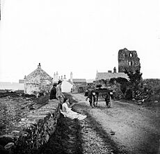
In the 1200s, the Scottish Bissett family built Olderfleet Castle at Curran Point. This castle was very important for its location. In 1315, Edward the Bruce of Scotland landed at Larne. He brought 6000 soldiers to try and conquer Ireland. He saw Ireland as another way to fight against England.
In 1569, Queen Elizabeth I of England and Ireland made Sir Moyses Hill the governor of Olderfleet Castle. It was key to England's plan to take control of Ulster.
After 1603, when Scotland, England, and Ireland were united under King James VI & I, many Scottish settlers came to Ulster. They often arrived through Larne during the Plantation of Ulster. Many Scottish people settled in County Antrim privately.
Emigration and Rebellion
During the 1700s, many Scots-Irish people left Larne for America. A monument in Curran Park remembers the Friends Goodwill. This was the first ship to sail from Larne with emigrants in May 1717. It went to Boston, Massachusetts, in the USA.
Larne was the first town in County Antrim taken by the United Irishmen. This happened during the rebellion of 1798. Protestant rebels, mostly Presbyterians, attacked government forces in Larne on June 7th. They drove the soldiers out of town. Then, the rebels marched to join Henry Joy McCracken at the Battle of Antrim.
In 1914, Loyalists were against the new Home Rule Act 1914. They prepared to fight. This led to the Larne Gun Running event. Weapons from Germany, Austria, and Italy were secretly brought into Larne and Bangor ports at night. They were then given out across Ulster. This event helped show that Ulster Unionists wanted to decide their own future. This eventually led to the creation of Northern Ireland.
The Troubles
During a period known as The Troubles, Larne had a strong presence of groups like the Ulster Volunteer Force (UVF) and Ulster Defence Association (UDA).
The town experienced several bomb attacks by the Provisional Irish Republican Army (IRA). One notable attack was a large car bomb at the King's Arms hotel in 1980. This bomb damaged the main shopping areas.
There were also some sad incidents where people lost their lives. These events were part of the wider conflict.
Geography of Larne
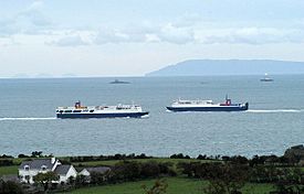
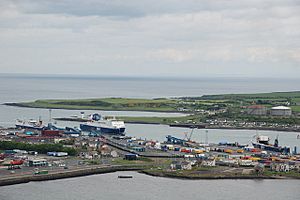
In the front is Islandmagee in Northern Ireland. Then you see Stena Line ferries near Larne. In the distance are the Scottish Paps of Jura and Mull of Kintyre.
Larne is on the west side of a narrow waterway. This waterway connects Larne Lough to the sea. On the other side of this waterway is a peninsula called Islandmagee.
To the west of Larne are the ancient Antrim Plateau mountains. These mountains have valleys carved by glaciers. These valleys sweep down to the sea north of Larne. They are known as the beautiful Glens of Antrim.
Larne is only about 25 miles from Scotland. You can often see the Scottish mainland from the Larne area. You might spot the Mull of Kintyre, Rhins of Galloway, Islay, and Paps of Jura. Being so close to Scotland has greatly shaped Larne's history and culture.
The town is part of a small parish with the same name. This parish is divided into smaller areas called townlands. Here are some townlands in Larne's urban area and what their names likely mean:
- Antiville (from An Tigh Bhile meaning "the house of the old tree")
- Ballyboley (from Baile Buaile meaning "townland of the dairy place")
- Ballycraigy (from Baile Creige meaning "townland of the rocky outcrop")
- Ballyloran (from Baile Loairn meaning "Loarn's townland")
- Blackcave North
- Blackcave South
- Curran and Drumalis (from Córran meaning "crescent" and Druim a' Lios meaning "ridge of the ringfort")
- Greenland
- Inver (from Inbhear meaning "rivermouth")
Many street names in Larne end in brae. This word comes from the Scots language and means "hillside". An example is 'Whitla's Brae'.
Civil parish of Larne
The civil parish includes these townlands: Antiville, Ballyboley, Ballycraigy, Ballyloran, Blackcave North, Blackcave South, Curran and Drumaliss, Glebe, Greenland and Town Parks.
Gallery
Places of Interest
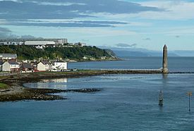
Larne has several lovely parks. These include Town Park, Chaine Park, Curran Park, and Smiley Park. For fun activities, you can visit Larne Leisure Centre or the Larne Museum & Arts Centre.
There are also two golf courses nearby. Cairndhu Golf Course is on top of Ballygally Head. Larne Golf Course is on the Islandmagee peninsula.
A very old and important building is Olderfleet Castle.
About 5 miles south of Larne, along Larne Lough, is Magheramorne. This place has a film studio. It was used to film many scenes for the famous HBO TV series Game of Thrones.
Population of Larne
2021 Census
On March 21, 2021, the census counted 18,853 people living in Larne. Here are some interesting facts about them:
- About 17.77% were under 16 years old.
- Most people, 63.10%, were between 16 and 65 years old.
- About 19.13% were aged 66 and over.
- Slightly more than half, 51.27%, were female.
- About 62.4% were brought up Protestant or other Christian faiths.
- About 23.9% were brought up Catholic.
- About 12.8% did not follow any religion.
- Many people, 66.6%, felt they had a British national identity.
- About 38.3% felt they had a Northern Irish national identity.
- About 10.3% felt they had an Irish national identity. (People could choose more than one identity).
- About 17.51% knew some Ulster Scots.
- About 3.84% knew some Irish (Gaeilge).
Industry and Commerce
Ballylumford power station, Northern Ireland's main power station, is near Larne. Other energy companies in Larne include B9 Energy, which develops renewable energy.
Larne is also home to the main offices of Caterpillar (NI) Limited. This company makes diesel and gas generators. Other businesses include InspecVision, which makes industrial inspection equipment. TerumoBCT, a Japanese company, makes medical products like intravenous drip solutions. The LEDCOM (Larne Enterprise Development Company) business park also provides space for many companies.
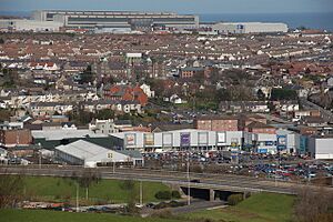
You can find many shops in Larne along Main Street, Dunluce Street, and at Laharna Retail Park. There are also large supermarkets near the Harbour Highway. A market is held every Wednesday at the Larne Market Yard.
Transport in Larne
Ferry Services
Ferries sail from Larne Harbour to Cairnryan in Scotland. P&O Irish Sea operates these passenger services. They say these crossings are "the shortest, fastest crossings" because Larne is so close to Scotland. There has even been a suggestion to build an Irish Sea Bridge connecting Larne with Portpatrick in Scotland.
Road Connections
Larne is linked to Belfast by the A8 road. The A2 road, also known as the 'Antrim coast road', runs along the coast. It passes through the beautiful Glens of Antrim and serves the town. South of Larne, the A2 road goes along Larne Lough. It passes through Glynn, Magheramorne, and Ballycarry, leading to Whitehead and Carrickfergus. The A36 road connects Larne to Ballymena.
Train Services
The Belfast–Larne railway line connects Larne to Belfast Grand Central and Belfast Lanyon Place. It passes through towns like Whitehead, Carrickfergus, and Jordanstown. This line connects Larne to the wider Northern Ireland Railways network. Currently, there are no freight trains in Northern Ireland. Both Larne Town railway station and Larne Harbour railway station opened in 1862. They stopped carrying goods in 1965.
The Ballymena and Larne Railway was a special "narrow gauge" railway. This means its tracks were closer together than standard tracks. It opened in 1878, stopped carrying passengers in 1933, and closed completely in 1950. Another train line used to run from Larne to Ballyclare. You can still see parts of its path along the Six Mile valley.
Public Services
Larne Town Hall was finished in 1870. It used to be the main office for Larne Borough Council. Moyle Hospital offers some health services, but its emergency department is now closed.
Education
For secondary education, students in Larne can attend Larne Grammar School or Larne High School. For further education after school, there is Northern Regional College (which used to be Larne Technical College).
Notable People from Larne
Many interesting people have come from Larne. Some examples include:
- Dianne Barr, a paralympic swimmer.
- Keith Gillespie, a famous footballer who played for Sheffield United F.C. and the Northern Ireland national football team.
- Valerie Hobson, a well-known actress.
- Sir Ivan Magill, an important anaesthetist who went to Larne Grammar School.
- Gareth McAuley, a football defender for West Bromwich Albion.
- Jonathan Rea, a champion Superbike World Championship rider.
- Norman Surplus, the first person to fly around the Earth in an Autogyro.
Freedom of the Borough
In 2008, the Royal Irish Regiment was given the "Freedom of the Borough" of Larne. This special honour allows the regiment to march through the town with 'flags flying, bands playing and bayonets fixed'. This event also marked a battle in Musa Qala, Afghanistan, in 2006. A new regimental march, called Musa Qala, was created for the regiment.
Events
The Friends Goodwill Music Festival happens every May. It celebrates and supports local music.
Sport
Larne F.C. is a professional association football club from the town. They play in the NIFL Premiership. Other local amateur football clubs include Larne Technical Old Boys F.C. and Wellington Recreation F.C..
Twin City
Larne has a "twin city" relationship with Clover, South Carolina in the United States. Clover has even named one of its schools, Larne Elementary School, after Larne!
Notable Facts
- A mineral called Larnite is named after Larne.
See also
 In Spanish: Larne para niños
 | Janet Taylor Pickett |
 | Synthia Saint James |
 | Howardena Pindell |
 | Faith Ringgold |


