
Rhins of Galloway facts for kids
The Rhins of Galloway, also called the Rhins of Wigtownshire, is a hammer-head shaped piece of land (a peninsula) in Dumfries and Galloway, Scotland. It stretches over 25 miles (40 km) from north to south. Its very southern tip is called the Mull of Galloway, which is the southernmost point in all of Scotland.

The main towns and villages here are Stranraer (at the top of Loch Ryan) and the small tourist village of Portpatrick on the west coast. Other villages you'll find include Kirkcolm, Leswalt, Lochans, and in the southern part of the Rhins: Stoneykirk, Sandhead, Ardwell and Drummore.
The word "Rhinns" comes from an old word, rionn or rinn, which means a point or a piece of land sticking out into the sea.
Geography and Climate of the Rhins
This peninsula has the North Channel on its west side, and Loch Ryan and Luce Bay on its east side. With about 50 miles (80 km) of coastline, the sea really shapes the land here. The west coast has steep, rugged cliffs and some small bays. The eastern coast, however, is calmer with sandy beaches and a softer landscape.
The Rhins gets a lot of wind from the west, coming from the Atlantic Ocean. This means it gets a good amount of rain, about 1000 mm (40 inches) each year. Because of this, the land is mostly used for farming, especially for dairy cows and beef cattle.
Since the land is almost surrounded by sea, its temperature stays quite steady. The North Atlantic Current keeps the land cooler in summer and warmer in winter. This means there are not many hard frosts. Because of this mild weather, many tropical plants, like palms, can grow here, even though it's so far north! You can see these amazing plants at the Logan Botanic Garden.

The natural shape of the Rhins has been very important for its development. The whole peninsula acts like a giant wall against the strong currents of the North Channel. This makes the waters in Loch Ryan and Luce Bay much calmer and safer for boats. This is why ferries that sail to Belfast and Larne use these waters. They used to be based at Portpatrick, but as ships got bigger, they needed more protected harbours. So, they moved to the calm waters of Loch Ryan, where they still sail from today.
The very southern tip of the Rhins is the Mull of Galloway, which is also the southernmost point in Scotland. This area, with its land and rocky cliffs, is home to many different animals and plants. The Mull is a special protected area called a Site of Special Scientific Interest and also an RSPB nature reserve. Birds like Razorbills, guillemots, and puffins build their nests on the steep cliffs here.
Just north of the Mull, the land becomes very narrow. This narrow strip, called an isthmus, separates two bays (East and West Tarbets). A long time ago, people would pull their boats across this narrow land using logs. They did this to avoid sailing around the dangerous currents near the Mull of Galloway.
The Southern Upland Way, a long walking path, starts in the Rhins at Portpatrick. It winds through the area on its long journey east across Scotland.
History and Settlements
The Rhins of Galloway has a long history, going back to ancient times. The Britons lived in the southern part of the Rhins. Their leaders lived in hill-forts, like Dunman, which was 400 feet (120 meters) above sea level. They also built strong forts, like the one between East and West Tarbet, to protect the Mull of Galloway from attackers.

The Novantae Celtic tribe lived in the Rhins area. The Romans called this area Novantarum Peninsula. Around 81 AD, a Roman road was built from Dalswinton west to the Rhins, ending at Stranraer. Some people think that if the Roman general Agricola attacked Ireland, he might have done it from here.
For much of its history, people in the Rhins lived a simple life, growing their own food and fishing for their families. Fishing was mostly for local use, not for selling far away. Because there were very few people living here, big changes didn't happen until the Industrial Revolution.
Over time, the resources of the area were used more and more, not just locally but also for export. For centuries, salt pans on the west coast were used to get salt. Harvesting kelp (seaweed) also became popular, both for local uses and to be sent away for making chemicals. Sand, silt, and gravel were also often dug up from quarries.
As ways to travel and communicate improved, the area became richer. Sea links to Ireland, Glasgow, and Liverpool allowed farmers to sell their produce, which encouraged them to grow more food. These links also brought in goods that weren't found in the area.
The Rhins' closeness to Ireland led to important developments, like the railway line to Portpatrick. This line was built to make sure mail boats could quickly get to Donaghadee in Ireland. But as the ships got bigger, Portpatrick's harbour wasn't safe enough. So, in 1849, the shipping routes moved to the calmer waters of Stranraer Harbour in Loch Ryan.

During the Second World War, the Rhins became an important place for fighting against U-boats (German submarines). Flying boats operated from RAF Station Wig Bay and RAF Station Stranraer on the Loch side of the peninsula. RAF Corsewall, north of Kirkcolm, was mainly used to train flying boat pilots. The bombing range in Luce Bay was used a lot during the war, with facilities at West Freugh and Drummore.
Today, the peninsula is covered in farms. However, more and more, the area is focusing on tourism as small-scale farming becomes harder to make a living from. The beautiful natural environment, with its long, rugged coastline and many small bays, attracts visitors. The small population is also a big plus, as many tourist spots are becoming too crowded. The natural beauty of the area was even chosen by the BBC to film the drama Two Thousand Acres of Sky in the village of Port Logan.

Here are some interesting places to visit in and around the Rhins:
- Corsewall Lighthouse: Located at the northern end of the peninsula, it is now a four-star hotel.
- Lochnaw Castle: Near Leswalt, this is the old home of the Clan Agnew family.
- West Freugh: An RAF station near Stoneykirk that was (and still is, to a smaller extent) used for bombing target practice out in Luce Bay.
- Dunskey Castle: Near Portpatrick, this castle was built in the 1500s. Only its ruins remain today.
- Port Logan: The village where the BBC drama Two Thousand Acres of Sky was filmed. Nearby is the Logan outstation of the Royal Botanic Garden, Edinburgh.
- Ardwell House & Gardens: Near Ardwell, these are the house and gardens of the Ardwell estates.
- Kirkmadrine Stones: Near Sandhead, these stones show some of the earliest Christian activity on the peninsula, dating back to the 400s.
- The Mull of Galloway: Scotland's southernmost point, with a lighthouse and an RSPB nature reserve.
Images for kids
-
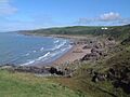
Killantringan Bay near Portpatrick
-
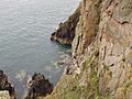
Cliffs at the Mull of Galloway


See also
 In Spanish: Rhins of Galloway para niños
