Clover, South Carolina facts for kids
Quick facts for kids
Clover, South Carolina
|
||
|---|---|---|

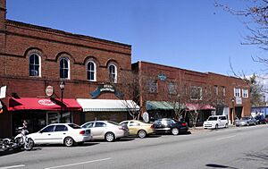
Clover Downtown Historic District
|
||
|
||
| Motto(s):
"The town with love in the middle."
|
||

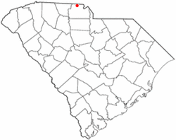
Location of Clover, South Carolina
|
||
| County | United States | |
| State | South Carolina | |
| County | York | |
| Area | ||
| • Total | 4.74 sq mi (12.28 km2) | |
| • Land | 4.73 sq mi (12.25 km2) | |
| • Water | 0.01 sq mi (0.03 km2) | |
| Elevation | 810 ft (250 m) | |
| Population
(2020)
|
||
| • Total | 6,671 | |
| • Density | 1,410.66/sq mi (544.65/km2) | |
| Time zone | UTC-5 (Eastern (EST)) | |
| • Summer (DST) | UTC-4 (EDT) | |
| ZIP code |
29710
|
|
| Area code(s) | 803 | |
| FIPS code | 45-15355 | |
| GNIS feature ID | 1221646 | |
Clover is a town in York County, South Carolina, United States. It's part of the larger Charlotte metropolitan area. In 2020, about 6,671 people lived within the town limits. Clover is also connected to the town of Larne in Northern Ireland, like a "sister city."
Contents
History of Clover
Clover was founded north of an older settlement called New Centre. That earlier town had become less important after the American Civil War, which was a big conflict in the United States from 1861 to 1865. A very important battle during the American Revolutionary War, called the battle of Kings Mountain, happened close to Clover in 1780. This war was when America fought for its independence from Great Britain.
Before Clover became a town, nearby communities like Bethany and Bethel were the main centers in northern York County. They had churches, post offices, and stores that served many cotton farms.
The village of Clover started in 1876 as a stop for trains. It was right in the middle of Yorkville and Gastonia, North Carolina. This was when the first train tracks were built through this part of the county.
A railroad called the Kings Mountain Railroad used to run through the area before the Civil War. But its tracks were destroyed during the war. Later, in 1873, a new railroad company called the Chester and Lenoir Narrow Gauge Railroad took over the old routes. By 1875, new, smaller train tracks were laid. The next year, the tracks were extended from Yorkville into North Carolina. A water tank was built for the trains' steam engines between Gastonia and Yorkville.
A fun story says that water overflowing from this tank helped a patch of clover grow. Because of this, the train stop was called "the clover patch." The town officially became incorporated in 1887.
Clover later became known for its cotton mills, which were factories that made cloth from cotton. Many of these mills operated until after World War II.
Two important historical places in Clover, the Bethel Presbyterian Church and the Clover Downtown Historic District, are listed on the National Register of Historic Places. This means they are recognized for their historical value.
Geography and Climate
Clover is located at 35°6′44″N 81°13′37″W / 35.11222°N 81.22694°W.
The town covers about 4.56 square miles (11.8 square kilometers). Most of this area is land, with a very small amount of water.
U.S. Highway 321 is Clover's Main Street. It runs north and south through the town. The town square is where Main Street crosses state highway 55.
West of Clover is a mountain called Henry's Knob. This mountain used to be a large mining site for a mineral called kyanite. Henry's Knob stands about 1,120 feet (341 meters) above sea level. The mining site is now being carefully managed to protect the environment.
Population Information
| Historical population | |||
|---|---|---|---|
| Census | Pop. | %± | |
| 1880 | 73 | — | |
| 1890 | 287 | 293.2% | |
| 1900 | 961 | 234.8% | |
| 1910 | 1,207 | 25.6% | |
| 1920 | 1,608 | 33.2% | |
| 1930 | 3,111 | 93.5% | |
| 1940 | 3,067 | −1.4% | |
| 1950 | 3,276 | 6.8% | |
| 1960 | 3,500 | 6.8% | |
| 1970 | 3,506 | 0.2% | |
| 1980 | 3,451 | −1.6% | |
| 1990 | 3,422 | −0.8% | |
| 2000 | 4,014 | 17.3% | |
| 2010 | 5,094 | 26.9% | |
| 2020 | 6,671 | 31.0% | |
| U.S. Decennial Census | |||
2020 Census Details
| Group | Number | Percentage |
|---|---|---|
| White (not Hispanic) | 4,545 | 68.13% |
| Black or African American (not Hispanic) | 1,142 | 17.12% |
| Native American | 27 | 0.4% |
| Asian | 64 | 0.96% |
| Other/Mixed | 403 | 6.04% |
| Hispanic or Latino | 490 | 7.35% |
In 2020, the town of Clover had 6,671 people. These people lived in 2,093 households, and 1,527 of these were families.
Education
The Clover School District has several schools. These include:
- Bethel Elementary School
- Bethany Elementary School
- Griggs Road Elementary School
- Kinard Elementary School
- Crowders Creek Elementary School
- Larne Elementary School (named after Clover's sister city)
- Oakridge Elementary School
- Clover Middle School
- Oakridge Middle School
- Blue Eagle Academy
- Clover High School
Clover also has a public library, which is part of the York County Library system.
Fun Things to Do
There are several places in and around Clover where you can have fun and enjoy the outdoors:
- Clover Community Park
- New Centre Park
- Roosevelt Park
- Crowder's Mountain State Park
- Kings Mountain State Park
- Field Day Park
International Friends
Clover has a special connection with another town across the ocean. This is called being "twinned" or having a "sister city" relationship.
See also
 In Spanish: Clover (Carolina del Sur) para niños


