Fair Head facts for kids
Quick facts for kids Fair Head |
|
|---|---|
| Irish: An Bhinn Mhór The Great Cliff | |
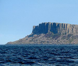
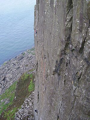
Fair Head's distinctive organ pipe dolerite columns, as taken from the Rathlin Island–Ballycastle ferry
|
|
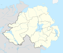
| Location | County Antrim, Northern Ireland |
| Nearest city | Ballycastle, 3 miles (5km) away |
| Coordinates | 55°13′16″N 6°09′14″W / 55.221°N 6.154°W |
| Climbing type |
|
| Height | Single pitch climbs of 20–30 meters. Multi pitch climbs of up to 100 meters |
| Pitches | Single pitch and Multi pitch |
| Ratings |
|
| Rock type | Dolerite sill |
| Quantity of rock |
|
| Development | Mountain cliff area; no facilities |
| Cliff aspect | North |
| Elevation | 196 metres at maximum |
| Ownership | Private land but farmers grant access |
| Camping | paid camping nearby; also in Ballycastle |
| Classic climbs |
|
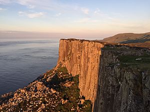
Fair Head, also known as Benmore (which means "The Great Cliff" in Irish), is an amazing 5-kilometer-long cliff by the sea. It's located in the north-eastern part of County Antrim, Northern Ireland. The rocks here look like giant organ pipes because they are shaped into tall, vertical columns. Fair Head is famous for being one of the best places in Ireland for rock climbing. Its long cliffs can be as high as 100 meters in some spots, making it one of the largest areas for climbing in Northwest Europe.
Contents
Fair Head's Natural Beauty and History
Fair Head is a stunning headland that rises 196 meters (about 643 feet) above the sea. You might even spot wild goats roaming among the rocks below the clifftops! There's a special path called The Grey Man's Path that winds along the rugged coastline.
From the road, you can see an old, man-made island in the middle of a lake called Lough na Cranagh. This island is an ancient crannóg from the Iron Age. The lakes are full of trout, and you can fish there during the summer.
Most of the land at Fair Head is private farmland. Local farmers are kind enough to allow visitors access. Fair Head is also the closest point on the mainland to Rathlin Island. Many famous Irish artists, like Maurice Canning Wilks, have painted the beautiful scenery of Fair Head.
Rock Climbing at Fair Head
Fair Head is known as one of Ireland's top outdoor rock climbing spots. It's often compared to the limestone sea-cliffs of Ailladie in County Clare. Not many climbers visit Fair Head because it's a bit far away. Also, the climbs here need a lot of physical strength and special climbing techniques.
The cliffs stretch for over 5 kilometers (about 3 miles) around the headland. They reach a maximum height of over 100 meters (about 328 feet). These aren't typical sea-cliffs; they're more like a huge mountain cliff right by the ocean. They stand above a large area of fallen rocks called a boulder field. Their size and isolation make climbing here feel like a big mountain adventure.
The Rocks and Climbing Style
The cliffs at Fair Head are made of a rock called dolerite. This rock creates a mix of steep cracked walls, corners, and many places with columns that look like organ pipes. The dolerite sits on top of a layer of chalk, which you can see in some spots.
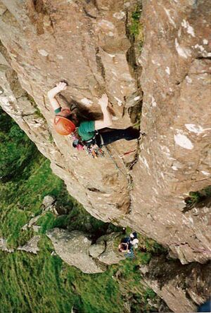
The cliffs are full of well-protected crack climbs. These climbs can be between one and four pitches long. A "pitch" is one section of a climb. Many of the cracks require a technique called hand-jamming. This means climbers wedge their hands into the cracks. Some climbers tape their hands to protect their skin from what they call "Fair Head rash"! Other climbs involve wider cracks or full-width chimneying. This is a technique where you climb inside a crack that's wide enough to fit your whole body.
At Fair Head, climbers use only traditional protection. This means they place removable gear into the rock as they climb to protect themselves if they fall. This is also known as "clean climbing". The 2014 Fair Head guidebook lists over 430 routes. These routes range from easier grades like VS 4c to very hard ones like E6 6b. More recent climbs go up to E8 6c.
A Brief History of Climbing
The first climbs at Fair Head happened in the mid-1960s. They were done by climbers from Belfast and the Dublin-based Spillikin Club. In the late 1970s, a husband-and-wife team, Calvin Torrans and Clare Sheridan, led the effort to develop more climbs. They, along with other Dublin climbers, formed the Dal Riada Climbing Club. They even got a climbing hut nearby for themselves and other visiting climbers. There are still parts of Fair Head that haven't been climbed yet, offering challenges for skilled climbers.
Climbing Areas at Fair Head
The cliffs at Fair Head are divided into several main sections:
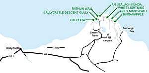
- The Small Crag: This section is about 20 meters (65 feet) high and has 70 climbs. It stretches for 1 kilometer (0.6 miles) above a heavily wooded hillside. Getting to this area can be tricky, often requiring climbers to abseil down.
- The Main Crag: This is the most important section, including The Prow at its western end. It curves around the headland for 3 kilometers (1.8 miles). Here you'll find the longest and best climbs, some reaching 100 meters (328 feet) high. Climbers usually get down to this area using two easy paths: the Grey Man's Path on the east or the Ballycastle Gully on the west.
- Farrangandoo: This is a popular smaller section with about 30 single-pitch climbs. It has columns with cracks every 2 meters or so.
- Marconi's Cove: This area was only discovered in 1988 and is about 500 meters (0.3 miles) away from the rest of the crag. It has about 25 good single-pitch climbs.
- Complete Scream: This cliff area features a route that is nearly 58 meters (190 feet) long. It's graded E8 6b, which is a very difficult climb. Complete Scream was first climbed in 2005 by Ricky Bell. In 2016, the famous U.S. climber Alex Honnold climbed this route alone, without ropes, and his climb was filmed!
Climbers often set up their base camps near the top of the paths that lead down to the cliffs. The walk to these spots is usually pleasant and short, through open fields. However, getting to some of the climbs themselves can be rough and take a lot of time.
Where to Stay When Visiting
The Dal Riada Climbing Club used to have special buildings called climbing huts where climbers could stay. But these huts were taken back by their owners in 2007. Now, most climbers either go camping at a nearby campsite run by a local farmer. Or, they can stay at a hostel in Ballycastle town, which has places to eat and drink.
Images for kids
 | Roy Wilkins |
 | John Lewis |
 | Linda Carol Brown |


