
Elevation facts for kids

When we talk about geography, elevation means how high a specific place is. We usually measure this height from a special starting point. Most often, this starting point is mean sea level. This is the average level of the ocean's surface.
Most land on Earth has a positive elevation, meaning it is above sea level. But some places, like certain deserts, are actually below sea level. These spots have a negative elevation.
Sometimes, elevation is measured from the very center of the earth. However, the Earth isn't a perfect ball. It's slightly squashed, like a flattened ball. This shape is called an oblate spheroid. Because of this, even if two places are at the same mean sea level, one might be farther from the Earth's center than the other. For example, the top of Chimborazo, a volcano in Ecuador, is farther from the Earth's center than the peak of Mount Everest. Yet, Mount Everest is much higher above sea level.
Contents
What is Elevation?
Elevation tells us how high a point is above a certain reference. Think of it like measuring how many floors up you are in a building. The ground floor would be your reference point. For mountains and valleys, our main reference is often the average level of the sea.
Measuring from Sea Level
Most maps and charts show elevation based on mean sea level. This is the average height of the ocean's surface.
- If a place is above sea level, it has a positive elevation. Most land fits into this group.
- If a place is below sea level, it has a negative elevation. This is less common, but you can find such spots in very deep valleys or deserts.
Measuring from Earth's Center
It's also possible to measure how far a place is from the center of the Earth. But this can be tricky!
- The Earth isn't perfectly round; it bulges a bit at the equator.
- This means a mountain near the equator, like Mount Chimborazo, can be farther from the Earth's center than a taller mountain like Mount Everest, which is closer to the poles.
- So, while Mount Everest is the highest point above sea level, Mount Chimborazo is the farthest point from the Earth's center.
Related Pages
More about elevation
 In Spanish: Elevación (ubicación geográfica) para niños
Images for kids
-
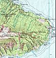
Part of a topographic map of Haleakala (Hawaii), showing elevation.
-
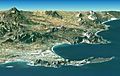
Landsat Image over SRTM Elevation by NASA, showing the Cape Peninsula and Cape of Good Hope, South Africa in the foreground. GIS or geographic information system is a computer system that allows for visualizing, manipulating, capturing, and storage of data with associated attributes. GIS offers better understanding of patterns and relationships of the landscape at different scales. Tools inside the GIS allow for manipulation of data for spatial analysis or cartography.
-

Heightmap of Earth's surface (including water and ice) in equirectangular projection, normalized as 8-bit grayscale, where lighter values indicate higher elevation.


