
Equirectangular projection facts for kids
The equirectangular projection is a simple way to draw maps. It's also called the geographic projection. People started using this type of map around 100 AD.
On an equirectangular map, lines of Longitude (which go up and down) and Latitude (which go side to side) are drawn as straight, even lines. Imagine stretching a globe flat like a rectangle – that's kind of what this map does!
Because the map is stretched, it's not very good for navigation (like finding your way on a ship or plane). But it's really useful for showing large areas of the world, especially when you want to see everything at once.

Contents
What is a Map Projection?
A map projection is a way to show the round surface of the Earth on a flat map. Imagine peeling an orange and trying to flatten the peel without tearing it. It's hard! Maps have the same problem. Different map projections try to solve this in different ways, but none of them can show the Earth perfectly flat without some stretching or squishing.
How the Equirectangular Projection Works
This projection is one of the simplest. It takes the curved lines of longitude and latitude from the globe and turns them into straight lines on a flat grid.
- Latitude lines (the horizontal ones, like the equator) are spaced equally apart.
- Longitude lines (the vertical ones, like the Prime Meridian) are also spaced equally apart.
This makes a grid of perfect squares or rectangles. It's easy to draw, but it makes places near the poles look much bigger and more stretched out than they really are. For example, Greenland might look as big as Africa, even though Africa is much, much larger!
Why Use This Map?
Even though it's not good for navigation, the equirectangular projection is useful for a few things:
- Showing the whole world: It's easy to see all parts of the Earth at once.
- Simple to create: It's one of the easiest maps to draw or create with computers.
- Art and decoration: You often see this type of map used for world maps on posters or in atlases because it looks neat and tidy.
- Computer graphics: It's often used in computer programs to store and display images of the Earth, like satellite photos.
Related pages
- Cartography
- Cassini projection
- Gall-Peters projection
- Panorama
Images for kids
-
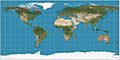
Equirectangular projection of the world; the standard parallel is the equator (plate carrée projection).
-
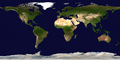
True-colour satellite image of Earth in equirectangular projection


See also
 In Spanish: Proyección cilíndrica equidistante para niños
