
Greenland facts for kids
Quick facts for kids
Greenland
Kalaallit Nunaat (Greenlandic) Grønland (Danish)
|
|||
|---|---|---|---|
|
|||
| Anthem: "Nunarput, utoqqarsuanngoravit" (Greenlandic) "Vort ældgamle land under isblinkens bavn" (Danish) "You Our Ancient Land" |
|||
| Kalaallit song: "Nuna asiilasooq" (Greenlandic) "The Land of Great Length" Royal anthems: Der er et yndigt land (Danish) (English: "There is a lovely country") |
|||
.svg)
Location of Greenland (dark green)
in the Kingdom of Denmark (light green) |
|||
| Sovereign state | Kingdom of Denmark | ||
| Union with Norway | 1262 | ||
| Danish-Norwegian recolonization | 1721 | ||
| Unification with Denmark | 14 January 1814 | ||
| Home rule | 1 May 1979 | ||
| Further autonomy and self rule | 21 June 2009 | ||
| Capital
and largest city
|
Nuuk 64°10′N 51°44′W / 64.167°N 51.733°W |
||
| Official languages | Greenlandic |
||
| Recognized languages | Danish, English, and other languages if necessary | ||
| Ethnic groups
(2020)
|
|
||
| Religion | Christianity (Church of Greenland) | ||
| Demonym(s) |
|
||
| Government | Devolved government within a parliamentary constitutional monarchy | ||
|
• Monarch
|
Frederik X | ||
| Mette Frederiksen | |||
|
• High Commissioner
|
Julie Præst Wilche | ||
| Jens-Frederik Nielsen | |||
|
• Speaker of the Inatsisartut
|
Mimi Karlsen | ||
| Legislature | Folketinget (Realm legislature) Inatsisartut (Local legislature) |
||
| National representation | |||
|
• Folketing
(2 members) |
|
||
| Area | |||
|
• Total
|
2,166,086 km2 (836,330 sq mi) | ||
|
• Water (%)
|
83.1 | ||
| Highest elevation | 3,700 m (12,100 ft) | ||
| Population | |||
|
• 2022 estimate
|
|||
|
• Density
|
0.028/km2 (0.1/sq mi) | ||
| GDP (PPP) | 2021 estimate | ||
|
• Total
|
|||
|
• Per capita
|
|||
| GDP (nominal) | 2021 estimate | ||
|
• Total
|
|||
|
• Per capita
|
|||
| Gini (2015) | medium |
||
| HDI (2010) | high · 61st |
||
| Currency | Danish krone (DKK) | ||
| Time zone | UTC±00:00 to UTC-04:00 | ||
| Date format | dd-mm-yyyy | ||
| Driving side | right | ||
| Calling code | +299 | ||
| Postal codes |
39xx
|
||
| ISO 3166 code | GL | ||
| Internet TLD | .gl | ||


Greenland (Greenlandic: Kalaallit Nunaat Danish: Grønland) is a huge island in North America. It is an autonomous territory of the Kingdom of Denmark. This means it has its own government but is still part of Denmark.
Greenland is the world's largest island. It lies between the Arctic and Atlantic oceans, east of Canada. The capital and largest city is Nuuk.
People have lived in Greenland for at least 4,500 years. The first people came from what is now Canada. Later, Norsemen from Norway and Iceland settled the southern part of Greenland around the 10th century. In the 13th century, Inuit people arrived.
Greenland became part of the Danish crown in 1814. In 1979, Denmark gave Greenland home rule, allowing it to manage many of its own affairs. In 2009, Greenland gained even more autonomy (self-rule). Denmark still handles things like citizenship, money, and defense.
Most people in Greenland are Inuit. About three-quarters of the island is covered by a huge ice sheet. With only about 56,583 people (in 2022), Greenland is the least densely populated place in the world.
Contents
What's in a Name?

The early Norse settlers called the island Greenland. This name comes from the Icelandic sagas. A man named Erik the Red was exiled from Iceland. He sailed to explore an icy land to the northwest.
After finding a good place to live, he named it Grœnland (Greenland). He hoped this nice name would attract more settlers. The Saga of Erik the Red says: "Erik left to settle in the country he had found, which he called Greenland, as he said people would be attracted there if it had a favorable name."
In the Greenlandic language, the territory is called Kalaallit Nunaat. This means "land of the Kalaallit". The Kalaallit are the Greenlandic Inuit people who live in western Greenland.
Greenland's Past
Early People of Greenland

Long ago, Greenland was home to different groups of Paleo-Inuit people. We know about them from things found by archaeologists. The first Paleo-Inuit arrived around 2500 BC.
From about 2500 BC to 800 BC, the Saqqaq culture lived in southern and western Greenland. Later, the Early Dorset culture appeared in western Greenland and the Independence II culture in northern Greenland. The Dorset culture was the first to spread along all of Greenland's coasts. They hunted whales and reindeer.
Norse Settlers Arrive

Around 986 AD, Icelanders and Norwegians led by Erik the Red settled on Greenland's west coast. They built three settlements. They shared the island with the Dorset culture people and later with the Thule culture.
The Norse settlements, like Brattahlíð, did well for hundreds of years. But they disappeared in the 15th century, possibly because of the Little Ice Age. This was a time when temperatures dropped a lot.

Scientists have studied ice cores and clam shells. They suggest that between 800 AD and 1300 AD, southern Greenland had a mild climate. Trees and plants grew, and livestock were farmed. But then, temperatures dropped significantly.
The Norse settlements vanished during the 14th and early 15th centuries. This was when the Little Ice Age began. Some theories suggest the Norse people might have been malnourished. Others think they left because the price of walrus ivory, their main export, dropped.
Thule Culture and Beyond
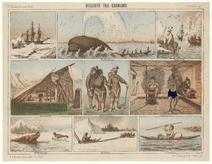
The Thule people are the ancestors of today's Greenlandic population. They came from Alaska around 1000 AD and reached Greenland around 1300 AD. The Thule people brought new tools like dog sleds and toggling harpoons.
There are stories from the Inuit about meeting and sometimes fighting with the Norse people.
Danish Rule and World War II
.png)
In 1500, Portugal sent explorers to Greenland. Later, in the early 17th century, Denmark-Norway re-established contact. In 1721, a missionary named Hans Egede started a new colony in Greenland. This colony was in Godthåb (now Nuuk) on the southwest coast.
When Denmark and Norway separated in 1814, Greenland stayed with Denmark. During World War II, Denmark was occupied by Nazi Germany. This cut Greenland off from Denmark.
The United States then occupied Greenland from 1941 to 1945 to protect it. Greenland was able to trade with the US and Canada. After the war, Greenland became an equal part of the Danish Kingdom in 1953.
Self-Rule and Modern Times

After World War II, the United States was interested in Greenland. In 1946, they even offered to buy the island from Denmark, but Denmark said no.

In 1950, Denmark allowed the US to use Thule Air Base. This base was expanded for NATO during the Cold War. The US also tried to build a secret nuclear missile site under the ice, called Project Iceworm. This project was later abandoned.
In 1979, Greenland gained home rule, meaning it could manage many of its own affairs. In 1985, Greenland left the European Economic Community (EEC) because it disagreed with fishing rules.
On June 21, 2009, Greenland gained even more self-rule. It took responsibility for its own legal system, policing, and natural resources. Greenlanders were also recognized as a separate people under international law. Denmark still controls foreign affairs and defense.
.jpg)
The Danish government still gives Greenland an annual grant. But as Greenland earns more from its natural resources, this grant will slowly decrease. This is seen as a step towards Greenland becoming fully independent from Denmark one day.
In 2019 and 2024, US President Donald Trump said the US wanted to buy Greenland again. But Greenland's Prime Minister, Múte Egede, clearly stated: "Greenland is ours. We are not for sale and will never be for sale."
Greenland's Nature and Weather

Greenland is the largest non-continental island in the world. It is located between 59° and 83°N latitude and 11° and 74°W longitude. Greenland is next to the Arctic Ocean, Greenland Sea, and North Atlantic Ocean.
The lowest temperature ever recorded in the Northern Hemisphere was in Greenland: -69.6°C (-93.3°F) in 1991. In Nuuk, the average temperature changes from -5.1°C (22.8°F) in winter to 9.9°C (49.8°F) in summer.
Most of Greenland, about 81%, is covered by the Greenland ice sheet. This ice sheet is huge, with a volume of about 2,850,000 cubic kilometers. The highest point in Greenland is Gunnbjørn Fjeld at 3,700 meters (12,100 feet).

Under the ice, there are deep canyons, including "Greenland’s Grand Canyon." These were formed by melting ice. All towns and settlements are along the ice-free coast, mostly on the west side.
The northernmost part of Greenland, Peary Land, is not covered by ice. This is because the air there is too dry for snow to fall and build up an ice sheet.
In 2007, a new island called "Uunartoq Qeqertaq" (Warming Island) appeared. It had always been there but was covered by a glacier. The glacier melted away, revealing the island. This shows how much the climate is changing.
Northernmost Land on Earth
For a long time, Cape Morris Jesup on mainland Greenland was thought to be the northernmost point of land. However, in 1969, Kaffeklubben Island was found to be even further north. Its northernmost point is 750 meters (2,460 feet) north of Cape Morris Jesup.
Other small land spots have been found even further north, but they might not be permanent. They could be rocky material on top of sea ice, not connected to the seafloor.
Climate Change in Greenland

The Greenland ice sheet usually balances ice loss from ice calving with new snowfall. But since the 1980s, Greenland has been losing more ice than it gains. The ice sheet melted fastest in the 2010s.
In 2012, 2019, and 2021, there were "massive melting events." Almost the entire surface of the ice sheet melted. In 2021, it even rained at Greenland's highest point for the first time ever recorded!
This melting ice adds to sea level rise. Between 2012 and 2017, Greenland's melting added about 0.68 mm (0.027 inches) to global sea levels each year. This was 37% of all sea level rise from land ice.

If all of Greenland's ice sheet melted, global sea levels would rise by about 7.4 meters (24 feet). But this would take at least 1,000 years, even with very high global warming. Scientists believe that if global temperatures rise by more than 1.7°C to 2.3°C (3.1°F to 4.1°F), the ice sheet will eventually disappear.
Animals and Plants

Greenland has two main natural areas: high arctic tundra and low arctic tundra. There are about 700 known insect species, which is not many compared to other countries. The sea around Greenland is full of fish and other sea creatures.
Greenland's native land mammals include the polar bear, arctic fox, arctic hare, and musk ox. Some, like the musk ox, only live in East Greenland. Many types of seals and whales live along the coast.
Greenland does not have any native reptiles or amphibians. Most land animals came from North America. Many birds and insects came from Europe.
Plant life is sparse, mostly grass and small shrubs. The most common native trees are the European white birch and different kinds of willow.
Greenland has about 500 species of "higher" plants, like flowering plants and ferns. There are also many types of lichens, fungi, and mosses. Most of Greenland's plants are found all around the Arctic.
.jpg)
Animals brought by people include the Greenland dog (by the Inuit) and Greenlandic sheep, goats, and cattle (by Europeans).

Many whales swim near Greenland's shores in late summer and early autumn. These include beluga whales, humpback whales, and narwhals. The fishing industry is very important to Greenland's economy.
Birds are a big part of Greenland's animal life. Many seabirds, like auks and puffins, breed on the steep mountainsides. Ducks, geese, and various migratory birds also live here.
How Greenland is Governed


Greenland has its own government that handles local affairs. The head of the government is called the Naalakkersuisut Siulittaasuat (Premier). Other cabinet members are called Naalakkersuisoq (Minister).
Greenland's parliament is called Inatsisartut (Legislators). It currently has 31 members. People in Greenland vote in local, national, and kingdom-level elections.
Greenland is a self-governing part of the constitutional monarchy of the Kingdom of Denmark. King Frederik X is the head of state. The King's power is mostly symbolic, like formally appointing the prime minister.
Political System
The main political parties are the social-democratic Forward Party and the democratic socialist Inuit Community Party. Both generally want more independence from Denmark.
In 2008, Greenlanders voted for more self-governance and autonomy. About 76% of voters supported this.
In 1985, Greenland left the European Economic Community (EEC), which later became the European Union (EU). Greenland still has some ties with the EU as an "Overseas Country and Territory."
Greenland's Government Structure
Greenland's head of state is King Frederik X. The Danish government appoints a high commissioner to represent it in Greenland.
Greenland elects two members to the Danish Parliament (Folketinget). This is out of a total of 179 members.
Greenland also has its own national Parliament with 31 representatives. The government, called the Naalakkersuisut, is led by the premier.
Military Presence
Several American and Danish military bases are in Greenland. One important base is Pituffik Space Base (formerly Thule Air Base). It helps the United States Space Force track missiles and space objects for North American Aerospace Defense Command (NORAD).
In 1968, a US B-52 bomber carrying nuclear bombs crashed near Thule Air Base. This caused a lot of radioactive pollution. One of the nuclear bombs is still missing.
Local Divisions
Greenland is divided into large areas called "municipalities." These are:
- Sermersooq ("Much Ice") around the capital Nuuk.
- Kujalleq ("South") in the south.
- Qeqqata ("Centre") north of Nuuk.
- Qeqertalik ("The one with islands") around Disko Bay.
- Avannaata ("Northern") in the northwest.
The northeast of the island is the Northeast Greenland National Park, which is not part of any municipality. Pituffik Space Base is also a separate area, managed by the United States Space Force.
Greenland's Economy
Greenland's economy relies heavily on fishing. Fishing products make up over 90% of Greenland's exports. The shrimp and fish industry brings in the most money.
Greenland also has many minerals. Mining for ruby began in 2007. There are also minerals like iron, uranium, aluminum, and platinum. In 2021, Greenland stopped all new oil and gas exploration. Officials said the environmental cost was too high.
Most electricity used to come from oil or diesel plants. But now, Greenland is building more hydropower plants, which use water to make clean energy.
About half of the government's money comes from grants from the Danish government. This is a big help to Greenland's economy.
Getting Around Greenland
Air travel connects places within Greenland and to other countries. There are also boats, but travel times are long because of the vast distances.
There are almost no roads between cities. This is because the coast has many fjords (long, narrow inlets of the sea) that would need ferries to connect a road network.
Nuuk Airport is the main airport for international and domestic flights. Air Greenland is Greenland's main airline. Icelandair also flies to Greenland.
Greenland has 13 civil airports and 47 helipads. Most airports have short runways, so only small planes can use them. International flights mostly connect to Copenhagen.
Coastal ferries provide sea passenger transport. The Arctic Umiaq Line makes one round trip per week along the coast. Royal Arctic Line handles cargo shipping to and from Greenland.
People and Culture
Population and Languages
.jpg)
In 2021, Greenland had about 56,421 people. Most Greenlanders live along the fjords in the southwest, where the climate is milder.
Most people in Greenland are Lutheran. The population is mostly of Greenlandic (Inuit and European mix) origin, with some Danish and other Nordic people.
A 2015 study found that modern Inuit in Greenland are direct descendants of the Thule people. They also have about 25% European ancestry from colonizers since the 16th century.

Greenlandic (Kalaallisut) became the only official language in 2009. Most people speak both Danish and Greenlandic. Danish is still used a lot in government and education. English is also taught in schools.
While West Greenlandic is the official language, about 3,000 people speak East Greenlandic. Nearly 1,000 people in northern Greenland speak Inuktun. These dialects are quite different from each other.
Education System
Education in Greenland is similar to Denmark's. Children have ten years of mandatory primary school. After that, they can go to secondary school for work training or to prepare for university.
Greenland has one university, the University of Greenland (Greenlandic: Ilisimatusarfik) in Nuuk. Many Greenlanders also go to universities in Denmark or other countries.
Education is free and compulsory for children aged seven to 16. The government spends a lot on education. Greenlandic is the main language of instruction. Danish is a compulsory second language from primary school.

The goal is to have Greenlandic-speaking and Danish-speaking students in the same classes. This helps all students get the same language, cultural, and social education. This bilingualism policy has been in place since 1994.
Higher education is available in Greenland for things like journalism, teaching, and nursing. Greenlandic students can also continue their education in Denmark. They can get scholarships if they meet certain requirements.
Religion and Beliefs
Religion in Greenland (2010): Protestantism (95.5%) Roman Catholicism (0.2%) Other Christian (0.4%) Inuit spiritual beliefs (0.8%) Agnostic (2.3%) Atheist (0.2%) Other religion (0.6%)

The nomadic Inuit people traditionally had shamanistic beliefs. Their religion often focused on pleasing a sea goddess named Sedna, who controlled hunting success.
The first Norse settlers worshipped Norse gods. But Erik the Red's son, Leif, became Christian and sent missionaries to Greenland. They built churches and a bishopric.
In the 18th century, Danish missionaries came to Greenland. They wanted to find the lost Norse settlements and spread the Protestant Reformation. They didn't find the Norse, but they started teaching the Inuit about Christianity.
Today, the main religion is Protestant Christianity, mostly the Church of Denmark. The Bishop of Greenland estimates that 85% of Greenlanders are members of her church.
Greenlandic Culture

.JPG)
Greenlandic culture is a mix of traditional Inuit (Kalaallit, Tunumiit, Inughuit) and Scandinavian cultures. Inuit culture has a strong artistic tradition going back thousands of years.
The Kalaallit are known for tupilak figures. These are "spirit objects" or sculptures of avenging monsters. Traditional art is still made in the Ammassalik region. Sperm whale ivory is a popular material for carving.
Music and Dance
Greenland has a small but lively music scene. Popular Greenlandic bands include Sumé (classic rock) and Nanook (rock). Rasmus Lyberth is a famous folk singer.
Traditional Inuit music often involves singing and drums. The drum is the traditional Greenlandic instrument. It was used for drum dances, where people would beat a round drum made of driftwood and animal skin.
Drum dances were used to scare away fear on dark winter nights and to settle arguments. People would try to make each other look silly with songs and drumming. The audience's laughter showed who won the argument.
After missionaries arrived, drum dances were sometimes banned. They were replaced by polyphonic (many-voiced) singing of church songs. Scandinavian and German sailors brought instruments like the fiddle and accordion.
Sports and Activities
Sports are very important in Greenland. Popular sports include association football, track and field, handball, and skiing. Handball is often called the national sport.
Greenland is great for skiing, fishing, snowboarding, ice climbing, and rock climbing. Mountain climbing and hiking are also popular. There is even a golf course in Nuuk!
Greenlandic Food
.png)
The national dish of Greenland is suaasat. This is a soup made from seal meat. Meat from sea mammals, game, birds, and fish are a big part of the Greenlandic diet. Most food comes from the ocean.
Spices are not used much, except for salt and pepper. Greenlandic coffee is a special "flaming" dessert coffee. It's made with coffee, whiskey, Kahlúa, Grand Marnier, and whipped cream.
Media and Arts
Kalaallit Nunaata Radioa (KNR) is Greenland's public broadcasting company. It has radio and television. Nuuk also has its own local TV channel, Nanoq Media.
Only two newspapers are published in Greenland, and both are national. Sermitsiaq is a weekly newspaper. Atuagagdliutit/Grønlandsposten is published twice a week in both Greenlandic and Danish.
The Inuit have their own arts and crafts. They carve tupilaks, which are sculptures of mythical or spiritual beings. Modern artists use local materials like musk ox wool, seal fur, and reindeer antlers.
The history of Greenlandic painting began with Aron von Kangeq in the mid-19th century. He drew old Greenlandic stories and myths. Later, artists like Kiistat Lund and Buuti Pedersen became known for their landscape paintings. There is an art museum in Nuuk.
See also
 In Spanish: Groenlandia para niños
- Faroe Islands
- Åland (Finland)
- Svalbard (Norway)
- Proposals for the United States to purchase Greenland
Images for kids
-
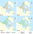
Estimated extent of Arctic cultures in Greenland from 900 AD to 1500 AD.

