Sermersooq facts for kids
Quick facts for kids
Sermersooq
Sted med meget is (Danish)
|
|||
|---|---|---|---|
|
Municipality
|
|||
| Sermersooq Municipality Kommuneqarfik Sermersooq (Greenlandic) |
|||

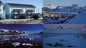
Clockwise from top left: Nuuk, Kulusuk, Tasiilaq, Kangertittivaq
|
|||
|
|||

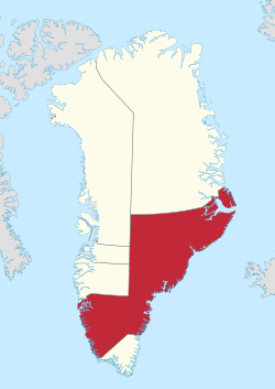
Location of Sermersooq within Greenland
|
|||
| Sovereign state | |||
| Autonomous country | |||
| Established | 1 January 2009 | ||
| Municipal center | Nuuk | ||
| Area | |||
| • Total | 531,900 km2 (205,400 sq mi) | ||
| Population
(2020)
|
|||
| • Total | 23,123 | ||
| • Density | 0.043472/km2 (0.112593/sq mi) | ||
| Time zone | UTC-03, UTC-01 | ||
| Calling code | +299 | ||
| ISO 3166 code | GL-SM | ||
| Website | sermersooq.gl | ||
Sermersooq is a huge area in Greenland. Its name means "place of much ice" in Danish, which makes sense because it has a lot of ice! It was created on January 1, 2009, by joining five smaller areas.
The main city and administrative center of Sermersooq is Nuuk. Nuuk is also the capital city of Greenland. Sermersooq is the most populated area in Greenland. In January 2020, about 23,123 people lived there.
Contents
How Sermersooq Was Formed
Sermersooq was created by combining five smaller municipalities (like counties or districts) from eastern and southwestern Greenland. Each of these smaller areas was named after its biggest town at that time.
The five former municipalities that joined to form Sermersooq were:
- Ammassalik Municipality
- Ittoqqortoormiit Municipality
- Ivittuut Municipality
- Nuuk Municipality
- Paamiut Municipality
Towns and Settlements in Sermersooq
Sermersooq is divided into different areas, each with its own towns and settlements. Here are some of the places you can find in this large municipality:
Ammassalik Area
- Tasiilaq (also known as Ammassalik)
- Kuummiit
- Kulusuk (also known as Kap Dan)
- Tiniteqilaaq
- Sermiligaaq
- Isortoq
Ittoqqortoormiit Area
- Ittoqqortoormiit (also known as Scoresbysund)
- Itterajivit
Ivittuut Area
- Kangilinnguit (also known as Grønnedal)
Nuuk Area
- Nuuk (also known as Godthåb)
- Kapisillit
- Qeqertarsuatsiaat (also known as Fiskenæsset)
Paamiut Area
- Paamiut (also known as Frederikshåb)
- Arsuk
Geography and Landscape
Sermersooq is located in the south-central and eastern parts of Greenland. It is incredibly large, covering an area of about 531,900 square kilometers (which is about 205,368 square miles). In 2018, it became the largest municipality in the world by land area!
To the south, Sermersooq shares a border with the Kujalleq municipality. This border runs along the Alanngorsuaq Fjord. The waters on the western side of Sermersooq are part of the Labrador Sea. This sea gets narrower to the north, forming the Davis Strait, which separates Greenland from Baffin Island. In the southwest, there's a special place called Ikka Fjord, famous for its unique ikaite columns. These are natural rock formations that look like tall pillars.
In the northwest, Sermersooq borders the Qeqqata municipality. Further north, it borders the Qeqertalik and Avannaata municipalities. However, these northern borders run right through the middle of the huge Greenland ice sheet (called Sermersuaq in Greenlandic). This means there's no traffic or easy way to cross these borders because of all the ice!
To the far north, Sermersooq meets the Northeast Greenland National Park. This happens near Cape Biot, at the northern end of Fleming Fjord. On the eastern side, near the town of Ittoqqortoormiit, the coast meets the Kangertittivaq fjord. This fjord opens up to the cold Greenland Sea. The southeastern coast of Sermersooq is next to the Anorituup Kangerlua fjord, which is part of the Irminger Sea in the North Atlantic Ocean.
Getting Around Sermersooq
Sermersooq is one of only two municipalities that stretch across both the western and eastern sides of Greenland. It's special because it's the only one where towns on both coasts are connected by regular flights.
You can fly from Nuuk Airport on the west coast to Kulusuk Airport and Nerlerit Inaat Airport on the east coast. These flights are operated by Air Greenland all year round. There are also local flights that connect Nuuk with Paamiut Airport on the west coast.
Languages Spoken
In Sermersooq, people speak different languages depending on where they live.
The main language spoken in the towns and settlements on the western coast is Kalaallisut. This is the West Greenlandic dialect of the Greenlandic language. In the bigger towns, you will also hear Danish.
On the eastern coast, people speak a different dialect called Tunumiit oraasiat, which is the East Greenlandic dialect.
See also
 In Spanish: Sermersooq para niños
 | John T. Biggers |
 | Thomas Blackshear |
 | Mark Bradford |
 | Beverly Buchanan |


