Davis Strait facts for kids
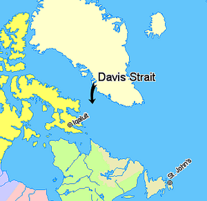
The Davis Strait (French: Détroit de Davis) is a large body of water in the northern Atlantic Ocean. It is located between mid-western Greenland and Baffin Island in Nunavut, Canada. To its north is Baffin Bay.
The strait is named after John Davis. He was an English explorer who lived from 1550 to 1605. He explored this area while looking for a Northwest Passage. This was a sea route through the Arctic. By the 1650s, people were using the strait for whale hunting.
How Davis Strait Was Formed
The land under the Davis Strait has a complex history. It was formed by huge cracks in the Earth's crust. These cracks are called faults. This happened about 45 to 62 million years ago. It was a time when the Earth's plates were moving. This movement helped create the Labrador Sea and Baffin Bay. The Davis Strait is known as the world's widest strait.
How Deep Is It?
The Davis Strait is not as deep as the Labrador Sea to its south. Its waters are usually between 1,000 and 2,000 meters deep.
Strong Tides
The strait is famous for its very strong tides. These tides can range from 30 to 60 feet (about 9 to 18 meters). These powerful tides made it hard for early explorers to travel through the area.
Oil and Gas Exploration
Experts believe that a lot of the world's undiscovered oil and gas is in the Arctic. The seas around Greenland might hold large amounts of natural gas. They may also have smaller amounts of crude oil.
Because of this, Greenland's government has offered areas for companies to search for oil and gas. The biggest areas are in the seas west of Greenland. These include the Davis Strait and Baffin Bay. There are also some smaller areas in the Greenland Sea to the east.
See also
 In Spanish: Estrecho de Davis para niños
 | Bessie Coleman |
 | Spann Watson |
 | Jill E. Brown |
 | Sherman W. White |


