
Ecuador facts for kids
Quick facts for kids
Republic of Ecuador
República del Ecuador (Spanish)
|
|
|---|---|
 Coat of arms
|
|
|
Anthem: Salve, Oh Patria (Spanish)
("Hail, Oh Fatherland") |
|

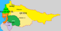
Location of Ecuador (dark green)
|
|
| Capital | Quito 00°13′12″S 78°30′43″W / 0.22000°S 78.51194°W |
| Largest city | Guayaquil |
| Official languages | Spanish |
| Recognized regional languages | Kichwa (Quechua), Shuar and others "are in official use for indigenous peoples" |
| Ethnic groups
(2022)
|
|
| Religion
(2020)
|
|
| Demonym(s) | Ecuadorian |
| Government | Unitary presidential republic |
| Daniel Noboa | |
| Verónica Abad Rojas | |
| Legislature | National Assembly |
| Independence | |
|
• Declared
|
10 August 1809 |
|
• from Spain
|
24 May 1822 |
|
• from Gran Colombia
|
13 May 1830 |
|
• Recognized by Spain
|
16 February 1840 |
|
• Liberal Revolution
|
5 June 1895 |
|
• Current constitution
|
28 September 2008 |
| Area | |
|
• Total
|
283,561 km2 (109,484 sq mi) (73rd) |
|
• Excluding the Galapagos Islands
|
256,370 km2 (98,990 sq mi) |
| Population | |
|
• 2023 estimate
|
17,483,326 |
|
• 2022 census
|
16,938,986 (73rd) |
|
• Density
|
69/km2 (178.7/sq mi) (148th) |
| GDP (PPP) | 2024 estimate |
|
• Total
|
|
|
• Per capita
|
|
| GDP (nominal) | 2024 estimate |
|
• Total
|
|
|
• Per capita
|
|
| Gini (2022) | ▼ 45.5 medium |
| HDI (2022) | high · 83rd |
| Currency | United States dollara (USD) |
| Time zone | UTC−5 / −6 (ECT / GALT) |
| Date format | dd/mm/yyyy |
| Driving side | right |
| Calling code | +593 |
| ISO 3166 code | EC |
| Internet TLD | .ec |
|
|

Ecuador is a country in South America. It is located right on the equator. Ecuador has amazing jungles, tall Andes mountains, and beautiful beaches along the Pacific Ocean.
The capital city is Quito, high up in the Andes mountains. Because it's so high, some new visitors might find it a bit hard to breathe. The largest city is Guayaquil, which is on the coast. Another famous city, Cuenca, is known for its old buildings and colonial style. Ecuador shares borders with Peru to the south and Colombia to the north. The famous Galápagos Islands are also part of Ecuador. These islands are full of unique animals and were visited by Charles Darwin.
Contents
Ecuador's History
Early Peoples Before the Incas
Long before the Incas arrived, different groups of people lived in the area that is now Ecuador. Scientists believe the first people came to the Americas about 16,500 to 13,000 years ago. They might have traveled by land from North America or by boat along the Pacific coast.
These early groups developed unique cultures based on where they lived.
- People on the coast were good at fishing, hunting, and gathering food.
- Those in the Andes mountains became farmers and settled down.
- People in the Amazon basin lived a nomadic life, hunting and gathering.
Over time, these groups started to interact and form communities. Many early civilizations grew in Ecuador. Some famous ones include the Valdivia Culture and Machalilla Culture on the coast. In the highlands, there were the Quitus near modern-day Quito and the Cañari near Cuenca. Each group created its own special buildings, pottery, and religious beliefs.
The Inca Empire in Ecuador
When the Incas expanded into Ecuador, it took them two generations to take control. This was because the local groups were already very well organized. The Incas moved some of the local people to other parts of their empire to prevent rebellions. They also brought loyal Inca people from Peru to Ecuador. This made highland Ecuador a part of the Inca Empire by 1463, and many people started speaking the same language.
However, the Incas found it harder to control the people on the coast and in the Amazon jungles. These groups were tougher to conquer and used guerrilla tactics. So, the Incas didn't fully expand into these areas. The people of the Amazon jungle and the Cayapas of coastal Ecuador kept their languages and cultures for a long time.
Before the Spanish arrived, the Inca Empire was in a civil war. The emperor, Huayna Capac, and his heir died from a European disease. This led to a fight for power between two brothers: Atahualpa and Huáscar. Atahualpa ruled from Quito, and Huáscar ruled from Cuzco.
Huáscar did not agree with his father's will. He wanted Atahualpa to come to Cuzco and accept him as the new ruler. But Atahualpa, who had many veteran soldiers, refused. A civil war began, and Atahualpa eventually captured Huáscar. Atahualpa then went to Cuzco and killed Huáscar's royal family.
Soon after, a small group of Spanish soldiers led by Francisco Pizarro landed in Tumbez. They marched into the Andes mountains and met Atahualpa in Cajamarca. A priest tried to convince Atahualpa to join the Catholic Church and become a Spanish subject. Atahualpa got angry and threw the Bible down. The Spanish then attacked, killed many of Atahualpa's guards, and captured him. Pizarro promised to free Atahualpa if he filled a room with gold. But after a quick trial, the Spanish executed Atahualpa.
Spanish Rule in Ecuador
After the Spanish arrived, many native people died from new diseases. They had no immunity to these illnesses. Also, the Spanish forced them into a labor system called encomienda. In 1563, Quito became an important administrative center for Spain. It was part of the Viceroyalty of Peru and later the Viceroyalty of New Granada.
After almost 300 years of Spanish rule, Quito was still a small city. On August 10, 1809, the local criollos (people of Spanish descent born in the Americas) in Quito called for independence from Spain. This was one of the first calls for independence in Latin America.
Gaining Independence

On October 9, 1820, Guayaquil was the first city in Ecuador to become independent from Spain. The rest of Ecuador gained its freedom after Antonio José de Sucre defeated the Spanish forces. This happened at the Battle of Pichincha, near Quito, on May 24, 1822. This date is now Ecuador's official independence day.
After gaining independence, Ecuador joined Simón Bolívar's Republic of Gran Colombia. This new country also included modern-day Colombia, Venezuela, and Panama. But in 1830, Ecuador separated from Gran Colombia and became its own independent republic.
The 19th century was a time of change for Ecuador. Many different leaders came and went. In 1851, Ecuador abolished slavery and freed its enslaved people.
The Liberal Revolution

The Liberal Revolution of 1895, led by Eloy Alfaro, changed things in Ecuador. It reduced the power of the church and wealthy landowners.
Changes to Ecuador's Borders

When Ecuador became independent in 1830, its first President, General Juan José Flores, claimed a large territory. This area was known as the Real Audiencia of Quito.
Over its history, Ecuador lost some of its claimed lands to its stronger neighbors.
- To Colombia in 1832 and 1916.
- To Brazil in 1904 through peaceful agreements.
- To Peru after a short war in 1942.
During the fight for independence, some areas like Guayaquil, Tumbez, and Jaén declared themselves free from Spain. However, Simón Bolívar wanted to create a new country called Gran Colombia. This country would include Colombia, Venezuela, and Ecuador. Bolívar, with the help of Antonio José de Sucre, took control of Guayaquil. They added the newly freed Audiencia de Quito to Gran Colombia.
Border Disputes with Peru


After Ecuador separated from Gran Colombia, Peru did not follow earlier agreements about borders. Peru started to occupy villages in the Amazon region, calling it Loreto. Peru claimed large parts of the Amazon Basin, which Ecuador and Colombia also claimed. Ecuador and Colombia protested, but Peru ignored them.
Peru briefly occupied Guayaquil again in 1860. This happened because Peru thought Ecuador was selling some disputed land. But Guayaquil was returned after a few months. The border dispute was sent to Spain for a decision, but it didn't help.
In the early 1900s, Ecuador tried to peacefully define its eastern borders. In 1904, Ecuador signed a treaty with Brazil. This recognized Brazil's claims in the Amazon but also confirmed Ecuador as an Amazonian country. In 1916, Ecuador and Colombia agreed on a border that ran between the Putumayo and Napo rivers.
In 1941, tensions grew with Peru near the Zarumilla River. War broke out. Peru claimed Ecuador had invaded its territory. Ecuador said Peru had invaded its land and had been taking disputed territories for a long time. In July 1941, both countries moved their troops. Peru had a much larger and better-equipped army.

During the Ecuadorian–Peruvian War, Peru took control of some disputed land. They also took parts of Ecuador's El Oro and Loja provinces. The Peruvian Navy blocked the port of Guayaquil, cutting off supplies to Ecuadorian troops. After a few weeks, the fighting stopped. This was due to pressure from the United States and other Latin American countries. Ecuador and Peru signed the Rio Protocol on January 29, 1942. This agreement favored Peru with the land they occupied when the war ended.
The Rio Protocol did not fully solve the border issue in the remote Cordillera del Cóndor mountains. This led to more disputes between Ecuador and Peru. There was a border fight in 1981, known as the Paquisha Incident. Then, in January 1995, there was a full-scale war called the Cenepa War. Both countries blamed each other. The Ecuadorian president, Sixto Durán Ballén, famously said he would not give up "a single centimeter of Ecuador."


Finally, Ecuador and Peru signed the Brasilia Presidential Act peace agreement on October 26, 1998. This ended the fighting and solved the longest-running border dispute in the Western Hemisphere.
Military Governments (1972–1979)
In 1972, a group of military leaders took over the government. This was a "revolutionary and nationalist" junta. General Guillermo Rodríguez led the takeover. He remained in power until 1976. Then, another military government took over.
People in Ecuador started to demand democratic elections. A plan was put in place to return to a constitutional system. This plan allowed for new elections.
Return to Democracy
Elections were held on April 29, 1979, under a new constitution. Jaime Roldós Aguilera was elected president. He received over one million votes, which was a record at the time. He became president on August 10, 1979. He was the first democratically elected president after almost ten years of military rule.
In 1980, he started a new political party. He governed until May 24, 1981. Sadly, he died in a plane crash near the Peruvian border. His wife and the minister of defense also died.
Vice President Osvaldo Hurtado immediately took over as president. After him, León Febres Cordero became president in 1984. Rodrigo Borja Cevallos won the presidency in 1988. His government worked to improve human rights. He also opened Ecuador to more foreign trade.
In recent years, the native (Amerindian) population has become more active in politics. This has added to the changes in the country's democracy.
Ecuador's Population
As of 2011, about 14.4 million people lived in Ecuador. The population is made up of different ethnic groups. About 65% are Mestizo (mixed European and Indigenous). About 25% are Amerindian. Around 7% are white, and 3% are black. About 27% of the people live below the national poverty line.
The official language is Spanish. Many other indigenous languages are also spoken. Most people in Ecuador are Roman Catholics. However, Ecuador has religious freedom, so people can follow any religion they choose.
Ecuador is located on the equator. It has many active volcanoes. It also has one of the highest numbers of volcanoes in the world.
Historic Center of Quito
The Historic Center of Quito is one of the best-preserved old city centers in the Americas. In 1978, it was one of the first places to be named a UNESCO World Heritage Site. This historic area covers 320 hectares (790 acres). It is considered one of the most important historic places in Latin America.
It has about 130 large buildings. These buildings contain many paintings and sculptures, mostly with religious themes. There are also 5,000 other historic properties.
Presidential Palace

The Carondelet Palace is where the President of Ecuador works. It is in the historic center of Quito. This palace is next to Independence Square, also known as Plaza Grande. Other important buildings around the square include the Archbishop's Palace and the Metropolitan Cathedral.
The history of this building goes back to the 1570s. Most presidents of Ecuador have worked from this palace. The President and their family also live in a luxurious apartment on the third floor. Since 2007, President Rafael Correa made the palace a museum. Now, anyone can visit and see its cultural treasures.
Church of La Compañía de Jesús

Construction of this church began in 1605 and finished in 1765. La Compañía is one of Quito's most famous churches. Its main area is covered in gold leaf, gilded plaster, and wood carvings. It was inspired by two Jesuit churches in Rome. La Compañía is a very important example of Spanish Baroque architecture in South America.
Independence Square

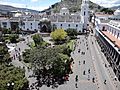
This square is also called Big Square (Plaza Grande). It is a historic public square in the heart of old Quito. It is a symbol of the country's government. The main feature is a monument to the heroes of independence. This monument remembers August 10, 1809, when people first called for independence from Spain. The square is surrounded by the Carondelet Palace, the Metropolitan Cathedral, and other important buildings.
Church of San Francisco
The Iglesia y Monasterio de San Francisco (Church and Monastery of St. Francis) is a colonial-style church and monastery. It is known as El San Francisco. Building began a few weeks after Quito was founded in 1534. It was finished in 1604. The Franciscan missionary Jodoco Ricke founded the church.
The building was officially opened in 1605. It's not known who designed the original plans. Some believe they were sent from Spain. Others think Ricke and Gosseal managed the whole construction.


Church of El Sagrario
The Church of El Sagrario was a great architectural work in colonial Quito. It was built in the late 17th century in the Italian Renaissance style. It has a screen that holds its sculptures and decorations. Bernardo de Legarda built this structure. Its central arch leads to a dome decorated with paintings of biblical scenes. The altarpiece was gilded by Legarda. It is located near the Cathedral.
Church of Santo Domingo

The Dominicans started building their church in 1580. The work was finished in the early 17th century. Inside, there are valuable structures, like the main altar. The church's roof has paintings of martyrs. The Chapel of Nuestra Señora del Rosario is another important part of the church. It is a well-known example of Quito's architecture.
El Panecillo
El Panecillo is a hill in the middle of Quito. It is about 3,016 meters (9,895 feet) above sea level. A large monument to the Virgin Mary stands on top of El Panecillo. You can see it from most of Quito. In 1976, a Spanish artist built the 41-meter (135-foot) tall aluminum statue. It was placed on a high base on the hill.

The Quito School of Art

The Quito School was an important art tradition. It grew in the area of the Royal Audience of Quito during Spanish colonial times (1542-1824). It started in an art school founded in 1552 by a Franciscan priest. This school trained the first native artists.
This art style mixes native and European cultures. It was a very important part of the economy in the Royal Audience of Quito. Famous artists from the Quito School include sculptors Bernardo de Legarda and Manuel Chili (Caspicara). Painters include Fray Pedro Gosseal and Miguel de Santiago.
Basilica del Voto Nacional

The Basilica of the National Vow is a large Roman Catholic church. It is in the historic center of Quito, Ecuador. It is the largest neo-Gothic basilica in the Americas.
The idea for the basilica came in 1883. It was meant to be a reminder of Ecuador's dedication to the Sacred Heart. Construction began in 1884. The basilica is still technically "unfinished." A local legend says that when the Basilica is completed, the end of the world will come.
Metropolitan Cathedral
Construction of the Metropolitan Cathedral began in 1562. This was seventeen years after the diocese of Quito was created. It is in the heart of the historic city. As the main church, it is a very important religious symbol for Catholics in Quito.
Church of San Agustín
This is one of seven large churches built in the 16th and 17th centuries. Its main entrance was built from stone in the Spanish Baroque-architecture style.
The church has a small entrance area with a large stone cross. Inside, there is a yard with a garden. There is also a large hall where friars held discussions. The bell tower is 22 meters (70 feet) tall. It holds two bronze bells from that time.
Climate in Ecuador
Ecuador is a country with a lot of variety. Its climate and landscape change from one part of the country to another. The coast and the Amazon jungle lowlands are hot and humid. The mountains, however, are cooler.


Plants and Animals


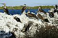
Ecuador is one of 17 megadiverse countries in the world. This means it has a huge variety of plants and animals. Besides the mainland, Ecuador also owns the famous Galápagos Islands. These islands are what the country is best known for.
Ecuador has 1,600 different bird species. An additional 38 bird species are found only in the Galápagos. There are over 16,000 species of plants. The country also has 106 unique reptiles, 138 unique amphibians, and 6,000 species of butterflies. The Galápagos Islands are famous because Charles Darwin developed his Theory of Evolution after visiting them. They are also a UNESCO World Heritage Site.
Interesting Facts About Ecuador
Many different kinds of potatoes and corn are grown in Ecuador. On the coast, people often eat seafood and fish. Cuy is a famous indigenous food, which is guinea pig.
Ecuador was once part of the Spanish Empire. Spain was interested in finding gold there. Before the Spanish, Ecuador was part of the Inca Empire.
There are large banana farms in Ecuador. Oil is one of Ecuador's important natural resources. Ecuador uses the United States dollar for its money. Its currency used to be the sucre.
Other Pages to Explore
Gallery of the Galapagos Islands, Ecuador
-
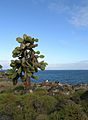
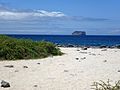
Prickly pear cactus and Swallow-tailed Gulls on Santa Fe Island
-
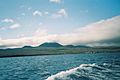
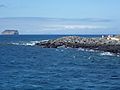
Floreana (Charles or Santa María) Island in the Galapagos
-
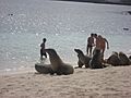
Tourists with sea lions at the beach at San Cristóbal Island
-
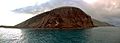
Rábida Island
-
Isabela Island, Blue-footed Boobies and a Galápagos Penguin at Elizabeth Bay
-
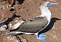
Blue-footed booby
-
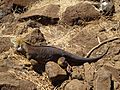
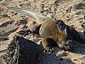
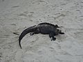
A Galapagos Land Iguana on the North Seymour Island in the Galapagos
-
(Sula nebouxii) Blue footed Booby on North Seymour Island Galapagos
-
North Seymour Island
-
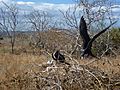
(Fregata magnificens) The Magnificent Frigatebird on North Seymour Island
-
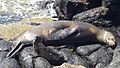
Seal with baby on North Seymour Island.
-
North Seymour Island
-
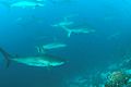
School of scalloped hammerheads, Wolf Island, Galapagos Islands
-
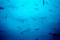
Another school of scalloped hammerheads at Wolf Island, Galapagos
-
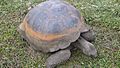
Gigantic galapagos turtle, Chelonoidis nigra on the island of Santa Cruz
-
Iguana on the beach at the Charles Darwin Research Station.
-
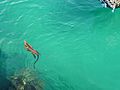
(Amblyrhynchus cristatus), Marine Iguana on Tortuga Bay - Island of Santa Cruz.
-
(Amblyrhynchus cristatus), Marine Iguana on Tortuga Bay - Island of Santa Cruz.
-
(Amblyrhynchus cristatus), Marine Iguana swimming in Puerto Ayora - Island of Santa Cruz.
-

(Grapsus grapsus) Santa Cruz Island, Galapagos Islands


_Gal%C3%A1pagos_Islands_Santa_Cruz.JPG)

Images for kids
-
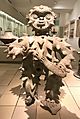
Tumaco-La Tolita mythological figure in feathered costume. Between 100 BC and 100 AD. Found in Esmeraldas
-
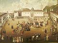
Major square of Quito. Painting of 18th century. Quito Painting Colonial School.
-
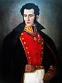
Venezuelan independence leader Antonio José de Sucre
-
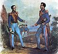
The "Guayaquil Conference" was the meeting between the two main Spanish South American independence leaders. In it the form of government of the nascent countries was discussed, San Martín opted for a unified South America in the form of a monarchy, while Bolívar opted for the same but into a republic. 1843 painting.
-
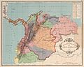
Map of the former Gran Colombia in 1824 (named in its time as Colombia), the Gran Colombia covered all the colored region.
-
Ecuador in 1832
-
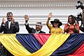
President Lenín Moreno, first lady Rocío González Navas and his predecessor Rafael Correa, 3 April 2017
-
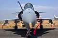
Ecuadorian Air Force (FAE)
-
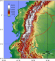
Ecuadorian topography
-
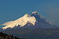
A view of the Cotopaxi volcano, in Cotopaxi Province
-
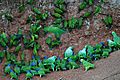
Birds in the Yasuni National Park
-
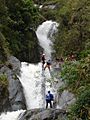
Baños de Agua Santa is an important tourist site
-
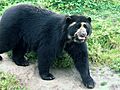
Ecuador is one of the most megadiverse countries in the world, it also has the most biodiversity per square kilometer of any nation, and is one of the highest endemism worldwide. In the image, the spectacled bear of the Andes.
-
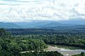
Amazon rainforest in Ecuador
-
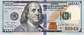
The United States dollar is the common currency circulation in Ecuador
-
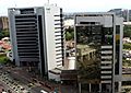
World Trade Center headquarters in Guayaquil
-
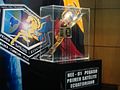
EXA's first satellite, NEE-01 Pegasus
-
The historic center of Quito has one of the largest and best-preserved historic centers in the Americas. The city also houses a large number of museums.
-
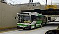
The Trolebús bus rapid transit system that runs through Quito. It is the principal BRT in Ecuador.
-
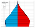
Population pyramid in 2020
-
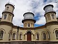
The oldest observatory in South America is the Quito Astronomical Observatory, founded in 1873 and located in Quito, Ecuador. The Quito Astronomical Observatory is managed by the National Polytechnic School.
-
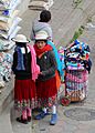
Cañari children with the typical Andean indigenous clothes
-
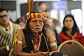
Huaorani man with the typical Amazonian indigenous clothes
-
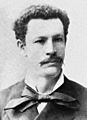
Juan Montalvo
-
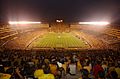
Estadio Monumental Isidro Romero Carbo of Guayaquil

.jpg)


_-_Carta_XI_-_Divisi%C3%B3n_pol%C3%ADtica_de_Colombia,_1824.jpg)


.jpg)


,_Plaza_de_la_Independencia_(Quito),_pic.aa4.jpg)


See also
 In Spanish: Ecuador para niños
